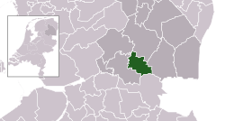
Hoogeveen
Hoogeveen [ˌɦoːɣəˈveːn] (![]() listen) (Dutch Law Saxon: 't Ogeveine or 't Oveine) is a municipality an a toun in the northeastren Netherlands.
listen) (Dutch Law Saxon: 't Ogeveine or 't Oveine) is a municipality an a toun in the northeastren Netherlands.
Hoogeveen | |
|---|---|
 Umwhile coort hoose in Hoogeveen | |
 Location in Drenthe | |
| Coordinates: 52°44′N 6°29′E / 52.733°N 6.483°ECoordinates: 52°44′N 6°29′E / 52.733°N 6.483°E | |
| Kintra | Netherlands |
| Province | Drenthe |
| Govrenment | |
| • Bodi | Municipal cooncil |
| • Mayor | Karel Loohuis (PvdA) |
| Area | |
| • Total | 129.25 km2 (49.90 sq mi) |
| • Laund | 127.67 km2 (49.29 sq mi) |
| • Water | 1.58 km2 (0.61 sq mi) |
| Elevation | 12 m (39 ft) |
| Population (Januar 2021)[4] | |
| • Total | 55,603 |
| • Density | 436/km2 (1,130/sq mi) |
| Demonym(s) | Hoogevener |
| Time zone | UTC+1 (CET) |
| • Summer (DST) | UTC+2 (CEST) |
| Postcode | Parts of 7900 range |
| Aurie code | 0524, 0528 |
| Website | www |
Internaitional relations
eeditTwin touns — Sister ceeties
eeditHoogeveen is twinned wi:
References
eedit- ↑ "De leden van het college" (in Dutch). Gemeente Hoogeveen. Archived frae the original on 5 Januar 2013. Retrieved 7 October 2013. Unknown parameter
|trans_title=ignored (help) - ↑ "Kerncijfers wijken en buurten" [Key figures for neighbourhoods]. CBS Statline (in Dutch). CBS. 2 Julie 2013. Retrieved 12 Mairch 2014.
- ↑ "Postcodetool for 7901BW". Actueel Hoogtebestand Nederland (in Dutch). Het Waterschapshuis. Archived frae the original on 24 December 2018. Retrieved 7 October 2013. Cite has empty unkent parameter:
|trans_title=(help) - ↑ "Bevolkingsontwikkeling; regio per maand" [Population growth; regions per month]. CBS Statline (in Dutch). CBS. 1 Januar 2021. Retrieved 2 Januar 2022.
