Godavari River
seicont langest river in Indie efter the river Ganges haein its soorce at Tryambakeshwar, Maharashtra
The Godavari River is the seicont langest river in Indie efter the river Ganges haein its soorce at Tryambakeshwar, Maharashtra.[4]
| Godavari | |
| Dakshina Ganga | |
| River | |
Dummugudem Barrage on Godavari in Khammam Destrict
| |
| Kintra | Indie |
|---|---|
| States | Maharashtra, Telangana, Chhattisgarh, Andhra Pradesh, Puducherry (Yanam) |
| Region | Sooth Indie, Wastren Indie |
| Tributaries | |
| - left | Banganga, Kadva, Shivana, Purna, Kadam, Pranahita, Indravati, Taliperu, Sabari |
| - right | Nasardi, Darna, Pravara, Sindphana, Manjira, Manair, Kinnerasani |
| Ceeties | Nashik, Nanded, Ramagundam, Rajamundry |
| Soorce | |
| - location | Brahmagiri Moontain, Tryambakeshwar, Nashik, Maharashtra, Indie |
| - elevation | 920 m (3,018 ft) |
| - coordinates | 19°55′48″N 73°31′39″E / 19.93000°N 73.52750°E |
| Mooth | |
| - location | Antarvedi intae Bay o Bengal, East Godavari, Andhra Pradesh, Indie |
| - elevation | 0 m (0 ft) |
| - coordinates | 17°0′N 81°48′E / 17.000°N 81.800°ECoordinates: 17°0′N 81°48′E / 17.000°N 81.800°E [1] |
| Lenth | 1,465 km (910 mi) |
| Basin | 312,812 km2 (120,777 sq mi) |
| Discharge | |
| - average | 3,505 m3/s (123,778 cu ft/s) [2] |
| Dischairge ensewhaur (average) | |
| - Polavaram (1901-1979) | 3,061.18 m3/s (108,105 cu ft/s) [3] |
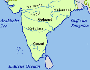
Path o the Godavari throu the Sooth Indie Peninsula
| |
References
eedit- ↑ Godāvari River at GEOnet Names Server
- ↑ Kumar, Rakesh; Singh, R.D.; Sharma, K.D (10 September 2005). "Water Resources of India" (PDF). Current Science. Bengaluru: Current Science Association. 89 (5): 794–811. Retrieved 13 October 2013.
- ↑ "Sage River Database". Archived frae the original on 21 Juin 2010. Retrieved 16 Juin 2011. Unknown parameter
|deadurl=ignored (help) - ↑ ""Godavari river basin map"" (PDF). Archived frae the original (PDF) on 12 October 2013. Retrieved 8 Julie 2016.

