File:Toronto map.png

Size o this luikower: 800 × 595 pixels. Ither resolutions: 320 × 238 pixels | 640 × 476 pixels | 1,024 × 761 pixels | 1,280 × 951 pixels | 1,500 × 1,115 pixels.
Oreeginal file (1,500 × 1,115 pixels, file size: 703 KB, MIME type: image/png)
|
| Descreeption |
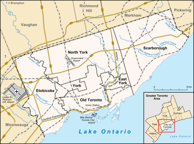
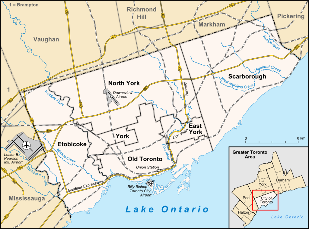
English: Map of Toronto
Français : Carte de Toronto
Deutsch: Karte von Toronto
Bahasa Indonesia: Peta kota Toronto |
| Date | |
| Soorce |
own work, used:
|
| Author | Lencer |

|
This map has been made or improved in the German Kartenwerkstatt (Map Lab). You can propose maps to improve as well.
|
This file is licensed unner the Creative Commons Attribution-Share Alike 3.0 Unported license.
- Ye are free:
- tae share – tae copy, distribute an transmit the wirk
- tae remix – tae adapt the wirk
- Unner the follaein condeetions:
- attribution – Ye must attribute the wirk in the manner specified bi the author or licensor (but nae in ony way that suggests that thay endorse ye or yer uise o the wirk).
- share alik – If ye alter, transform, or big upon this wirk, ye mey distribute the resultin wirk anly unner the same or seemilar license tae this ane.
File history
Clap oan ae date/time fer tae see the file aes it kithed at that time.
| Date/Time | Thummnail | Dimensions | Uiser | Comment | |
|---|---|---|---|---|---|
| current | 14:33, 3 Apryle 2012 | | 1,500 × 1,115 (703 KB) | Lencer | + don river, minor adds of river names |
| 15:59, 29 Juin 2009 |  | 1,500 × 1,115 (585 KB) | SimonP | correct minor error | |
| 15:18, 29 Juin 2009 |  | 1,500 × 1,115 (585 KB) | SimonP | Corect East York border | |
| 10:56, 18 Juin 2009 |  | 1,500 × 1,115 (677 KB) | Lencer | + don valley parkway | |
| 18:56, 25 Mairch 2009 |  | 1,500 × 1,115 (673 KB) | Lencer | Int. => Intl. | |
| 12:19, 18 Mairch 2009 |  | 1,500 × 1,115 (672 KB) | Lencer | Vaugahn -> Vaughan | |
| 06:54, 10 Mairch 2009 |  | 1,500 × 1,115 (673 KB) | Lencer | fix Greater Toronto Area | |
| 12:29, 9 Mairch 2009 |  | 1,500 × 1,115 (672 KB) | Lencer | + Minimap, some fixes | |
| 19:10, 8 Mairch 2009 |  | 1,500 × 1,116 (628 KB) | Lencer | weitere Kartenelemente erg., Farben geändert | |
| 20:02, 2 Mairch 2009 |  | 1,500 × 1,116 (475 KB) | Lencer | Fehlerhafte Grenze bei York |
Eimage airtins
The follaein pages airts tae this image:
Global file uisage
The follaein ither wikis uise this file:
- Uisage on ar.wikipedia.org
- Uisage on ban.wikipedia.org
- Uisage on ceb.wikipedia.org
- Uisage on ckb.wikipedia.org
- Uisage on de.wikipedia.org
- Toronto
- Benutzer:Lencer
- Wikipedia:Exzellente Bilder/Karten und Satellitenbilder
- Liste der Ortsteile von Toronto
- Wikipedia:Kartenwerkstatt/Archiv/2009-03
- Wikipedia:Kandidaten für exzellente Bilder/Archiv2009/6
- Datei:Toronto map.png
- Toronto Fire Services
- Taber Hill
- Wikipedia:Kartenwerkstatt/Schaufenster
- Wikipedia:Exzellente Bilder/Kleine Bilder
- Uisage on en.wikipedia.org
- Toronto
- Rogers Centre
- Yonge–Dundas Square
- Billy Bishop Toronto City Airport
- Don River (Ontario)
- Forest Hill, Toronto
- Humber River (Ontario)
- The Annex
- Royal Ontario Museum
- Cabbagetown, Toronto
- Rosedale, Toronto
- The Beaches, Toronto
- High Park
- The Kingsway, Toronto
- Baby Point
- Bendale
- The Junction
- Little Italy, Toronto
- New Toronto
- Leslieville
- Kensington Market
- Scotiabank Arena
- Riverdale, Toronto
- Metropolitan Toronto
- Union Station (Toronto)
- Swansea, Toronto
- Parkdale, Toronto
- Rouge River (Ontario)
- Ontario Science Centre
- Black Creek Pioneer Village
- Agincourt, Toronto
View mair global usage o this file.