File:South Yorkshire UK relief location map.jpg

Size o this luikower: 800 × 547 pixels. Ither resolutions: 320 × 219 pixels | 640 × 437 pixels | 1,024 × 700 pixels | 1,280 × 875 pixels | 1,999 × 1,366 pixels.
Oreeginal file (1,999 × 1,366 pixels, file size: 310 KB, MIME type: image/jpeg)
| Descreeption |
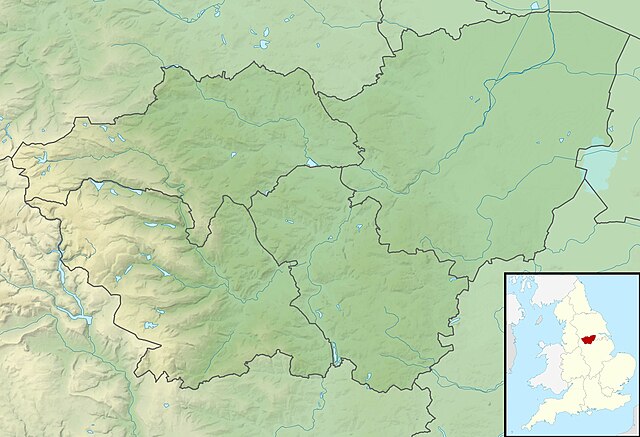
Relief map of South Yorkshire, UK. Equirectangular map projection on WGS 84 datum, with N/S stretched 165% Geographic limits:
|
| Date | |
| Soorce |
|
| Author | Nilfanion, created using Ordnance Survey data |
| Permission (Reuisin this file) |
This file is licensed unner the Creative Commons Attribution-Share Alike 3.0 Unported license. Attribution: Contains Ordnance Survey data © Crown copyright and database right
|
| Other versions | File:South Yorkshire UK district map (blank).svg - Blank map |
.svg)
File history
Clap oan ae date/time fer tae see the file aes it kithed at that time.
| Date/Time | Thummnail | Dimensions | Uiser | Comment | |
|---|---|---|---|---|---|
| current | 01:54, 29 November 2011 | | 1,999 × 1,366 (310 KB) | Nilfanion | {{Information |Description=Relief map of South Yorkshire, UK. Equirectangular map projection on WGS 84 datum, with N/S stretched 165% Geographic limits: *West: 1.84W *East: 0.85W *North: 53.67N *South: 53.26N |Source=[[w:Ordnance S |
Eimage airtins
The follaein pages airts tae this image:
Global file uisage
The follaein ither wikis uise this file:
- Uisage on ar.wikipedia.org
- Uisage on bg.wikipedia.org
- Uisage on ceb.wikipedia.org
- Uisage on en.wikipedia.org
- Highfields Lake
- RSPB Dearne Valley Old Moor
- Damflask Reservoir
- Agden Reservoir
- Derwent Edge
- Car Care Plan International
- Langsett Reservoir
- Margery Hill
- Module:Location map/data/United Kingdom South Yorkshire/doc
- Higger Tor
- Ulley Reservoir
- High Stones
- Strines Reservoir
- Module:Location map/data/United Kingdom South Yorkshire
- Module:Location map/data/South Yorkshire
- Winscar Reservoir
- More Hall Reservoir
- River Cheswold
- Ea Beck
- Rockingham Kiln
- Uisage on eo.wikipedia.org
- Uisage on es.wikipedia.org
- Uisage on fr.wikipedia.org
- Uisage on ja.wikipedia.org
- Uisage on kn.wikipedia.org
- Uisage on mk.wikipedia.org
- Uisage on mni.wikipedia.org
- Uisage on nl.wikipedia.org
- Uisage on os.wikipedia.org
- Uisage on pl.wikipedia.org
- Uisage on pl.wikibooks.org
- Uisage on simple.wikipedia.org
- Uisage on si.wikipedia.org
View mair global usage o this file.