File:Salawin river at Mae Sam Laep.jpg

Size o this luikower: 597 × 599 pixels. Ither resolutions: 239 × 240 pixels | 478 × 480 pixels | 765 × 768 pixels | 1,020 × 1,024 pixels | 1,594 × 1,600 pixels.
Oreeginal file (1,594 × 1,600 pixels, file size: 1.17 MB, MIME type: image/jpeg)
Ootline
| Camera location | | View this and other nearby images on: OpenStreetMap |
|---|
| Descreeption |
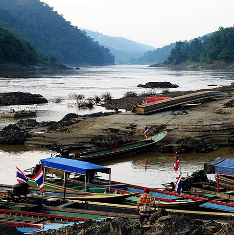
English: The Salawin river (a.k.a. the Nujiang river in China) at the border village of Mae Sam Laep. Myanmar is on the left bank |
| Date |
23 Apryle 2008 (original upload date) |
| Soorce | Ain wirk (Original text: self-made) |
| Author | Takeaway (talk) |
Licensin
Takeaway at Inglis Wikipaedia, the copyright holder of this work, hereby publishes it under the following licenses:
This file is licensed unner the Creative Commons Attribution-Share Alike 3.0 Unported license.
Attribution: Takeaway at Inglis Wikipaedia
- Ye are free:
- tae share – tae copy, distribute an transmit the wirk
- tae remix – tae adapt the wirk
- Unner the follaein condeetions:
- attribution – Ye must attribute the wirk in the manner specified bi the author or licensor (but nae in ony way that suggests that thay endorse ye or yer uise o the wirk).
- share alik – If ye alter, transform, or big upon this wirk, ye mey distribute the resultin wirk anly unner the same or seemilar license tae this ane.

|
Permission is grantit tae copy, distribute an/or modify this document unner the terms o the GNU Free Documentation License, Version 1.2 or ony later version published bi the Free Software Foundation; wi no Invariant Sections, no Front-Cover Texts, an no Back-Cover Texts. A copy o the license is includit in the section enteetled GNU Free Documentation License. |
Ye mey select the license o yer choice.
Original upload log
Transferred from en.wikipedia to Commons by Takeaway using CommonsHelper.
The original description page was here. All following user names refer to en.wikipedia.
- 2008-04-23 13:27 Takeaway 548×550×??? (101250 bytes) {{Information |Description= The Salawin river (a.k.a. the Nujiang river in China) at the border village of Mae Sam Laep |Source=self-made |Date=2005-10-18 |Author=~~~ |other_versions= }}
File history
Clap oan ae date/time fer tae see the file aes it kithed at that time.
| Date/Time | Thummnail | Dimensions | Uiser | Comment | |
|---|---|---|---|---|---|
| current | 12:59, 20 December 2009 | | 1,594 × 1,600 (1.17 MB) | Takeaway | same image, larger file and resolution |
| 05:48, 9 August 2008 |  | 548 × 550 (99 KB) | File Upload Bot (Magnus Manske) | {{BotMoveToCommons|en.wikipedia}} {{Information |Description={{en|The Salawin river (a.k.a. the Nujiang river in China) at the border village of Mae Sam Laep}} |Source=Transferred from [http://en.wikipedia.org en.wikipedia]; transferred to Commons by [[U |
Eimage airtins
The'r nae pages airts tae this eimage.
Global file uisage
The follaein ither wikis uise this file:
- Uisage on af.wikipedia.org
- Uisage on ar.wikipedia.org
- Uisage on arz.wikipedia.org
- Uisage on azb.wikipedia.org
- Uisage on ban.wikipedia.org
- Uisage on be.wikipedia.org
- Uisage on bg.wikipedia.org
- Uisage on bh.wikipedia.org
- Uisage on bn.wikipedia.org
- Uisage on ca.wikipedia.org
- Uisage on ceb.wikipedia.org
- Uisage on cy.wikipedia.org
- Uisage on de.wikipedia.org
- Uisage on en.wikipedia.org
- Uisage on en.wikivoyage.org
- Uisage on en.wiktionary.org
- Uisage on es.wikipedia.org
- Uisage on fa.wikipedia.org
- Uisage on fi.wikipedia.org
- Uisage on fr.wikipedia.org
- Uisage on fr.wikivoyage.org
- Uisage on gl.wikipedia.org
- Uisage on hi.wikipedia.org
- Uisage on hr.wikipedia.org
- Uisage on id.wikipedia.org
- Uisage on incubator.wikimedia.org
- Uisage on it.wikipedia.org
- Uisage on ja.wikipedia.org
- Uisage on ka.wikipedia.org
- Uisage on kk.wikipedia.org
- Uisage on ko.wikipedia.org
- Uisage on la.wikipedia.org
- Uisage on lt.wikipedia.org
View mair global usage o this file.