File:Potomacwatershedmap.png
Size o this luikower: 800 × 545 pixels. Ither resolutions: 320 × 218 pixels | 640 × 436 pixels | 1,024 × 698 pixels | 1,467 × 1,000 pixels.
Oreeginal file (1,467 × 1,000 pixels, file size: 1.41 MB, MIME type: image/png)
Ootline
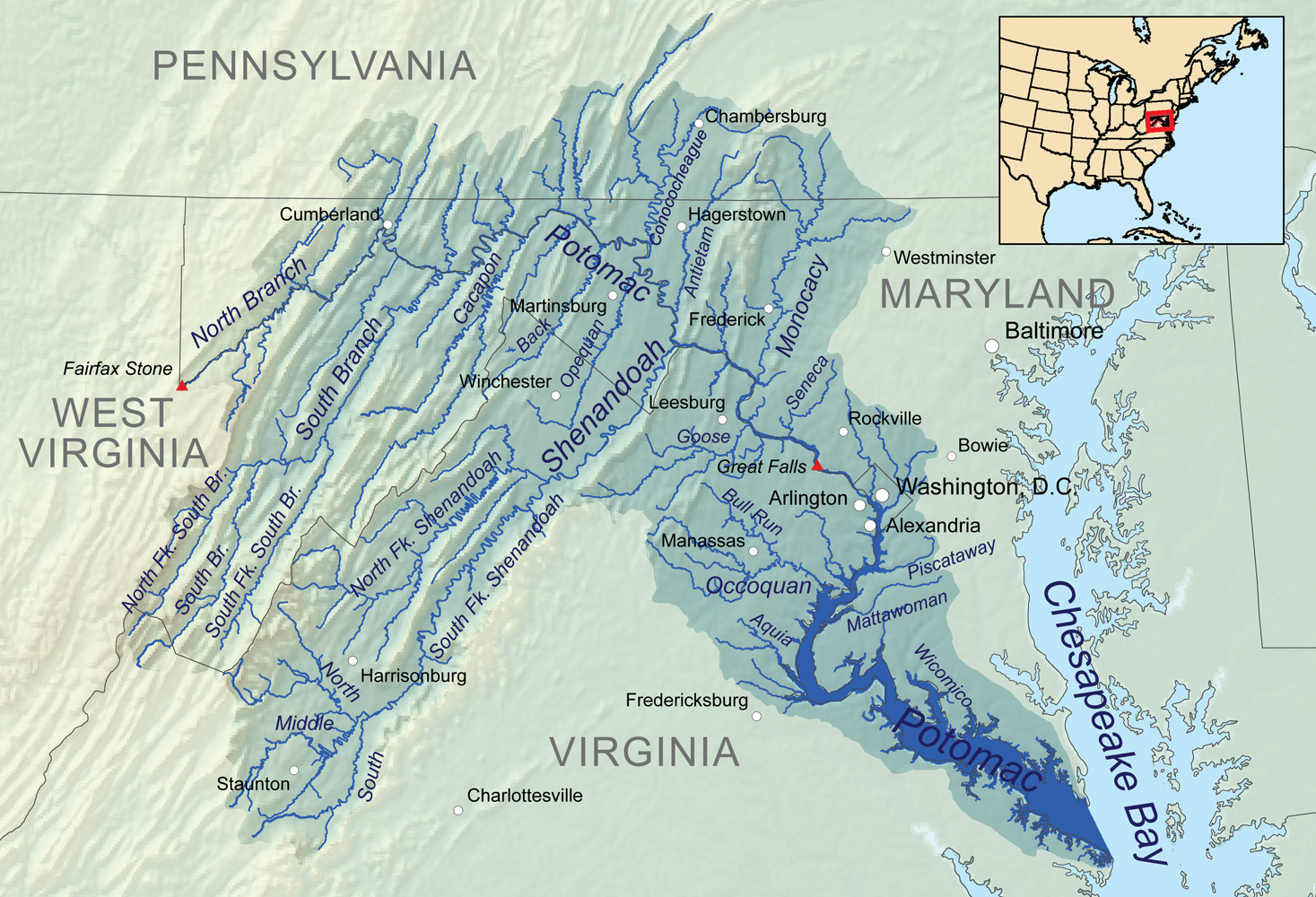
| Descreeption | Map showing the Potomac River drainage basin. |
| Date | |
| Soorce | Ain wirk, Elevation data from SRTM, hydrologic data from the National Hydrography Dataset, urban areas from Vector Map, all other features from the National Atlas. |
| Author | Kmusser |
| Other versions | File:Potomac watershed.png |
Licensin
I, the copyright holder of this work, hereby publish it under the following license:
This file is licensed unner the Creative Commons Attribution-Share Alike 3.0 Unported license.
- Ye are free:
- tae share – tae copy, distribute an transmit the wirk
- tae remix – tae adapt the wirk
- Unner the follaein condeetions:
- attribution – Ye must attribute the wirk in the manner specified bi the author or licensor (but nae in ony way that suggests that thay endorse ye or yer uise o the wirk).
- share alik – If ye alter, transform, or big upon this wirk, ye mey distribute the resultin wirk anly unner the same or seemilar license tae this ane.
File history
Clap oan ae date/time fer tae see the file aes it kithed at that time.
| Date/Time | Thummnail | Dimensions | Uiser | Comment | |
|---|---|---|---|---|---|
| current | 00:10, 4 Januar 2011 | | 1,467 × 1,000 (1.41 MB) | Kmusser | == Summary == {{Information |Description=Map showing the Potomac River drainage basin. |Source={{own}}, Elevation data from SRTM, hydrologic data from the [[:w:National Hydrography Dataset|Natio |
Eimage airtins
The'r nae pages airts tae this eimage.
Global file uisage
The follaein ither wikis uise this file:
- Uisage on ar.wikipedia.org
- Uisage on ast.wikipedia.org
- Uisage on azb.wikipedia.org
- Uisage on br.wikipedia.org
- Uisage on cs.wikipedia.org
- Uisage on de.wikipedia.org
- Uisage on en.wikipedia.org
- Uisage on eo.wikipedia.org
- Uisage on es.wikipedia.org
- Maryland
- Baltimore
- Cumberland (Maryland)
- Bowie (Maryland)
- Westminster (Maryland)
- Frederick (Maryland)
- Hagerstown (Maryland)
- Río Potomac
- Charlottesville
- Condado de Arlington
- Alexandria (Virginia)
- Harrisonburg
- Winchester (Virginia)
- Fredericksburg (Virginia)
- Staunton (Virginia)
- Manassas (Virginia)
- Chambersburg
- Leesburg (Virginia)
- Great Falls (Virginia)
- Martinsburg (Virginia Occidental)
- Washington D. C.
- Río Shenandoah
- Uisage on fi.wikipedia.org
- Uisage on fr.wikipedia.org
- Uisage on he.wikipedia.org
- Uisage on hu.wikipedia.org
- Uisage on io.wikipedia.org
- Uisage on la.wikipedia.org
- Uisage on lv.wikipedia.org
- Uisage on mt.wikipedia.org
- Uisage on pms.wikipedia.org
- Uisage on pnb.wikipedia.org
- Uisage on pt.wikipedia.org
- Uisage on sh.wikipedia.org
- Uisage on sr.wikipedia.org
- Uisage on sv.wikipedia.org
View mair global usage o this file.