File:Noord-Holland position.svg

Size of this PNG preview of this SVG file: 200 × 236 pixels. Ither resolutions: 203 × 240 pixels | 407 × 480 pixels | 651 × 768 pixels | 868 × 1,024 pixels | 1,736 × 2,048 pixels.
Oreeginal file (SVG file, nominallie 200 × 236 pixels, file size: 158 KB)
Ootline
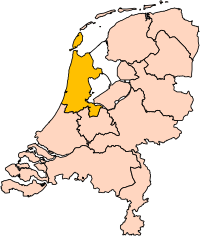
| Descreeption | Location of the province of Noord-Holland (North Holland) in the Netherlands. |
| Date | |
| Soorce | Own work, based on freely available GIS data |
| Author | User:Mtcv |
| Permission (Reuisin this file) |
Data: attribution required; my work: PD |
| Other versions | I attempted to make an svg version of Image:Noord Holland-Position.png (with less simplified boundaries) |
Clickable version

Licensin

|
The copyright holder of this file, Centraal Bureau voor de Statistiek, allows anyone to use it for any purpose, provided that the copyright holder is properly attributed. Redistribution, derivative work, commercial use, and all other use is permitted. |
Attribution:
|
| Annotations | This image is annotated: View the annotations at Commons |


File history
Clap oan ae date/time fer tae see the file aes it kithed at that time.
| Date/Time | Thummnail | Dimensions | Uiser | Comment | |
|---|---|---|---|---|---|
| current | 17:20, 2 Mairch 2019 | | 200 × 236 (158 KB) | Thayts | update |
| 15:13, 2 October 2006 |  | 200 × 236 (158 KB) | Mtcv | {{Information| |Description=Location of the province of Noord-Holland (North Holland) in the Netherlands. |Source=Own work, based on freely available GIS data |Date=2006-10-02 |Author=User:Mtcv |Permission=Data: attribution required; my work: PD |othe |
Eimage airtins
The'r nae pages airts tae this eimage.
Global file uisage
The follaein ither wikis uise this file:
- Uisage on ar.wikipedia.org
- أمستردام
- شمال-هولندا
- هلفرسوم
- ألكمار
- هارلم (شمال-هولندا)
- زانستاد
- هارلمرمير
- قالب:بلديات شمال هولندا
- سخاخن
- دن هيلدر
- فيلسن
- زانتفورت
- بلوميندال
- ألسمير
- لاندسمير
- أوستزان
- تيسل
- أمستلفين
- إنكهاوزن
- هورن (هولندا)
- فاترلاند
- بيمستر
- بيفيرفايك
- بيرخن (شمال هولندا)
- بلاريكوم
- هيمستيده
- بوابة:أمستردام/قوالب
- بوابة:أمستردام
- حكومة أمستردام
- هارلمرليده آن سبارنفاودا
- آودر- أمستل
- ديمين
- فيسب (هولندا)
- كاستركوم
- دريخترلاند
- إدام- فولندام
- هيمسكيرك
- هيرهوخوفارد
- هيلو (هولندا)
- هولاندز كرون
- هاوزن
- كوخينلاند
- لانجادايك
- لارين (هولندا)
- ميديمبليك
- أوبمير
- بورميراند
- ستيده بروك
- آوتخيست
- آوتهورن
View mair global usage o this file.