File:NE 1200ad.jpg

Size o this luikower: 800 × 567 pixels. Ither resolutions: 320 × 227 pixels | 640 × 453 pixels | 1,024 × 725 pixels | 1,280 × 907 pixels | 1,464 × 1,037 pixels.
Oreeginal file (1,464 × 1,037 pixels, file size: 1.43 MB, MIME type: image/jpeg)
Ootline

|
This historical map image could be re-created using vector graphics as an SVG file. This has several advantages; see Commons:Media for cleanup for more information. If an SVG form of this image is available, please upload it and afterwards replace this template with
{{vector version available|new image name}}.
It is recommended to name the SVG file “NE 1200ad.svg”—then the template Vector version available (or Vva) does not need the new image name parameter. |


| Descreeption |
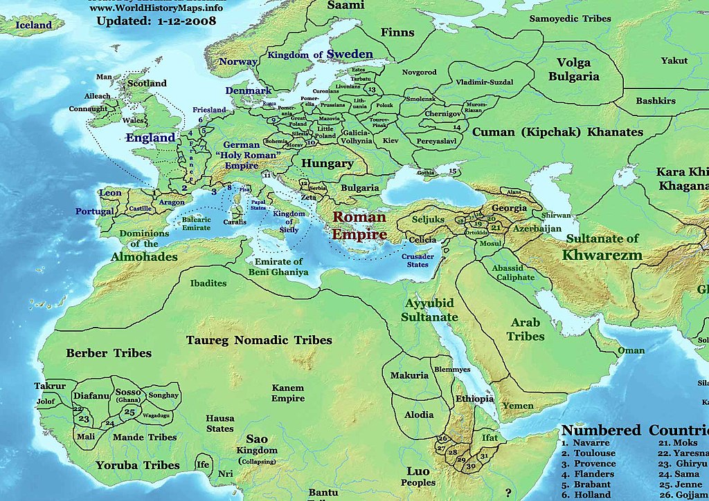
English: This image is a zoomed-in version of Eastern Hemisphere in 1200 AD (East-Hem_1200ad.jpg).
Author: Thomas A. Lessman. Source URL: http://www.ThomasLessman.com/History/images/East-Hem_1200ad.jpg. Image was created by me (Thomas Lessman) based on map of Eastern Hemisphere in 1200AD. Image is free for public and/or educational use. I would appreciate a mention if this image is used elsewhere. If anyone is interested in helping further this work, please contact Thomas Lessman at talessman@yis.us. Other Historical Maps by Thomas Lessman |
| Date | 3 December 2007 (original upload date) |
| Soorce | Transferred from en.wikipedia to Commons by Sdrtirs. |
| Author | Talessman at Inglis Wikipaedia |
Licensin
Talessman at Inglis Wikipaedia, the copyright holder of this work, hereby publishes it under the following licenses:

|
Permission is grantit tae copy, distribute an/or modify this document unner the terms o the GNU Free Documentation License, Version 1.2 or ony later version published bi the Free Software Foundation; wi no Invariant Sections, no Front-Cover Texts, an no Back-Cover Texts. A copy o the license is includit in the section enteetled GNU Free Documentation License. |
This file is licensed under the Creative Commons Attribution 3.0 Unported license.
Attribution: Talessman at Inglis Wikipaedia
- Ye are free:
- tae share – tae copy, distribute an transmit the wirk
- tae remix – tae adapt the wirk
- Unner the follaein condeetions:
- attribution – Ye must attribute the wirk in the manner specified bi the author or licensor (but nae in ony way that suggests that thay endorse ye or yer uise o the wirk).
Ye mey select the license o yer choice.
Original upload log
The original description page was here. All following user names refer to en.wikipedia.
- 2008-01-14 21:44 Talessman 1439×1035×8 (475084 bytes) Corrected borders of Scandinavia
- 2008-01-11 22:15 Talessman 1457×1002×8 (467243 bytes) Corrected some borders in Africa, made some names easier to read, etc.
- 2007-12-03 19:50 Talessman 1647×1270×8 (602681 bytes) This image is a zoomed-in version of [http://en.wikipedia.org/wiki/Image:East-Hem_800ad.jpg Eastern Hemisphere in 800 AD]. [[Image:East-Hem_800ad.jpg|thumb|300px|left|Eastern Hemisphere in 800 AD.]] Author: Thomas A. Lessman. Source URL: h
File history
Clap oan ae date/time fer tae see the file aes it kithed at that time.
| Date/Time | Thummnail | Dimensions | Uiser | Comment | |
|---|---|---|---|---|---|
| current | 21:17, 11 Januar 2009 | | 1,464 × 1,037 (1.43 MB) | Ukabia | {{Information |Description= |Source= |Date= |Author= |Permission= |other_versions= }} |
| 01:22, 10 Apryle 2008 |  | 1,439 × 1,035 (464 KB) | File Upload Bot (Magnus Manske) | {{BotMoveToCommons|en.wikipedia}} {{Information |Description={{en|thumb|300px|left|Eastern Hemisphere in 1200 AD. This image is a zoomed-in version of [http://en.wikipedia.org/wiki/Image:East-Hem_1200ad.jpg Eastern Hem |
Eimage airtins
The follaein pages airts tae this image:
Global file uisage
The follaein ither wikis uise this file:
- Uisage on azb.wikipedia.org
- Uisage on en.wikipedia.org
- Uisage on es.wikipedia.org
- Uisage on id.wikipedia.org
- Uisage on ka.wikipedia.org
- Uisage on ru.wikipedia.org