File:Mount Yatsu.JPG

Size o this luikower: 800 × 600 pixels. Ither resolutions: 320 × 240 pixels | 640 × 480 pixels | 1,024 × 768 pixels | 1,280 × 960 pixels | 2,560 × 1,920 pixels | 4,608 × 3,456 pixels.
Oreeginal file (4,608 × 3,456 pixels, file size: 5.71 MB, MIME type: image/jpeg)
Ootline
| Descreeption |
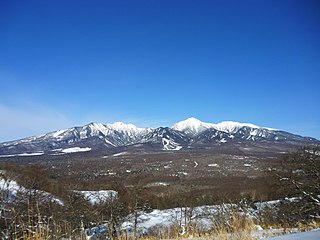
English: Yatsugatake Mountains in Nagano Prefecture and Yamanashi Prefecture, Japan. A view from Hirasawa Pass in Minamimaki, Nagano. |
| Date | |
| Soorce | Ain wirk |
| Author | Ski Mania |
| Camera location | | View this and other nearby images on: OpenStreetMap |
|---|
Licensin
| I, the copyright holder of this work, release this work into the public domain. This applies worldwide. In some countries this may not be legally possible; if so: I grant anyone the right to use this work for any purpose, without any conditions, unless such conditions are required by law. |
File history
Clap oan ae date/time fer tae see the file aes it kithed at that time.
| Date/Time | Thummnail | Dimensions | Uiser | Comment | |
|---|---|---|---|---|---|
| current | 22:12, 18 Februar 2013 | | 4,608 × 3,456 (5.71 MB) | Ski Mania | User created page with UploadWizard |
Eimage airtins
The follaein pages airts tae this image:
Global file uisage
The follaein ither wikis uise this file:
- Uisage on arz.wikipedia.org
- Uisage on en.wikipedia.org
- Uisage on fa.wikipedia.org
- Uisage on ja.wikipedia.org
- Uisage on www.wikidata.org