File:Marianatrenchmap.png

Size o this luikower: 460 × 599 pixels. Ither resolutions: 184 × 240 pixels | 369 × 480 pixels | 756 × 984 pixels.
Oreeginal file (756 × 984 pixels, file size: 758 KB, MIME type: image/png)
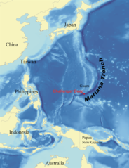
This is a picture of what it looks like from a satellite perspective.
Ootline
| Descreeption |
English: Map showing the location of the Mariana Trench, designed as a replacement for en:Image:Mariana_trench_location.jpg. Français : Carte montrant la position de la fosse des Mariannes.
Latina: Haec charta locum Fossae Marianae demonstrat. |
| Date | |
| Soorce | self-made using data from NOAA[dead link]. |
| Author | wallace |
Licensin
I, Kmusser, the copyright holder of this work, hereby publishes it under the following licenses:

|
Permission is grantit tae copy, distribute an/or modify this document unner the terms o the GNU Free Documentation License, Version 1.2 or ony later version published bi the Free Software Foundation; wi no Invariant Sections, no Front-Cover Texts, an no Back-Cover Texts. A copy o the license is includit in the section enteetled GNU Free Documentation License. |
| This file is licensed unner the Creative Commons Attribution-Share Alike 3.0 Unported license. | ||
| Attribution: I, Kmusser | ||
| ||
| This licensing tag was added to this file as part of the GFDL licensing update. |
This file is licensed under the Creative Commons Attribution 2.5 Generic license.
Attribution: I, Kmusser
- Ye are free:
- tae share – tae copy, distribute an transmit the wirk
- tae remix – tae adapt the wirk
- Unner the follaein condeetions:
- attribution – Ye must attribute the wirk in the manner specified bi the author or licensor (but nae in ony way that suggests that thay endorse ye or yer uise o the wirk).
Ye mey select the license o yer choice.
File history
Clap oan ae date/time fer tae see the file aes it kithed at that time.
| Date/Time | Thummnail | Dimensions | Uiser | Comment | |
|---|---|---|---|---|---|
| current | 21:39, 14 Juin 2020 | | 756 × 984 (758 KB) | Roy17 | lossless crop from 2007 original, then annotated |
| 08:43, 2 Juin 2016 |  | 756 × 985 (604 KB) | McGeddon | Cropped 1 % horizontally and < 1 % vertically using CropTool with precise mode. Crop out 1px black border. | |
| 06:09, 8 Januar 2008 |  | 761 × 989 (598 KB) | Lee Carre | File size efficiency, reduced my 50KB without loss of image data. | |
| 15:26, 2 August 2007 |  | 773 × 1,000 (658 KB) | Kmusser | {{Information |Description=Map showing the location of the Mariana Trench, designed as a replacement for en:Image:Mariana_trench_location.jpg. |Source=self-made using [http://www.ngdc.noaa.gov/seg/fliers/se-1104.shtml|data from |
Eimage airtins
The'r nae pages airts tae this eimage.
Global file uisage
The follaein ither wikis uise this file:
- Uisage on af.wikipedia.org
- Uisage on ar.wikipedia.org
- Uisage on ary.wikipedia.org
- Uisage on ast.wikipedia.org
- Uisage on azb.wikipedia.org
- Uisage on az.wikipedia.org
- Uisage on ba.wikipedia.org
- Uisage on be-tarask.wikipedia.org
- Uisage on be.wikipedia.org
- Uisage on bg.wikipedia.org
- Uisage on bn.wikipedia.org
- Uisage on br.wikipedia.org
- Uisage on bs.wikipedia.org
- Uisage on ca.wikipedia.org
- Uisage on ceb.wikipedia.org
- Uisage on ce.wikipedia.org
- Uisage on ckb.wikipedia.org
- Uisage on cs.wikipedia.org
- Uisage on da.wikipedia.org
- Uisage on el.wikipedia.org
- Uisage on en.wikipedia.org
- Challenger Deep
- Mariana Trench
- Abyssal plain
- Kaikō ROV
- User:Kmusser/Images
- Portal:Geology
- Nereus (underwater vehicle)
- Marianas Trench Marine National Monument
- Deep-sea community
- Wikipedia:ITN archives/2009/June
- User:DiverDave/Deep sea communities
- List of submarine topographical features
- User:سائغ/T
- Hadal zone microbial communities
- Uisage on en.wikibooks.org
- Uisage on en.wikinews.org
- Uisage on eo.wikipedia.org
- Uisage on es.wikipedia.org
View mair global usage o this file.