File:Map of South Africa with English labels.svg

Size of this PNG preview of this SVG file: 684 × 599 pixels. Ither resolutions: 274 × 240 pixels | 548 × 480 pixels | 876 × 768 pixels | 1,168 × 1,024 pixels | 2,337 × 2,048 pixels | 809 × 709 pixels.
Oreeginal file (SVG file, nominallie 809 × 709 pixels, file size: 540 KB)
W3C-validity not checked.
Ootline
| Descreeption |
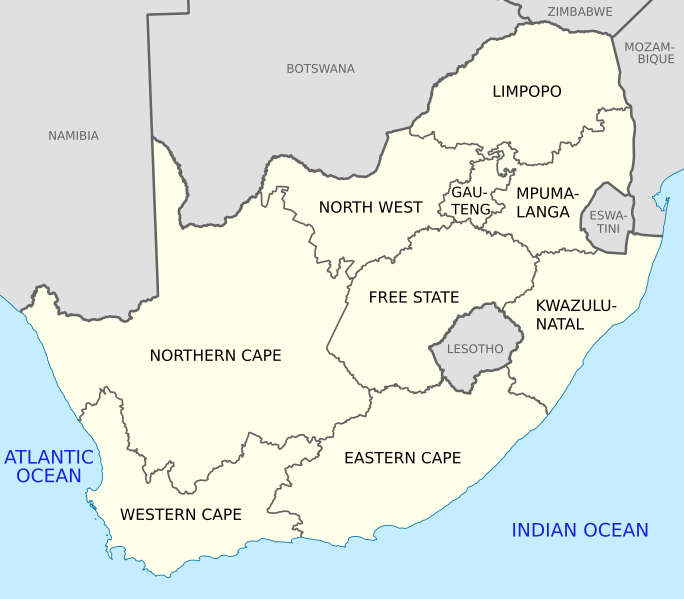
English: Map of South Africa, with provinces, neighbouring countries and oceans labelled in English. Based on File:Map of South Africa with provincial borders.svg. |
| Date | |
| Soorce | Ain wirk |
| Author | Htonl |
| Other versions |
Licensin
I, the copyright holder of this work, hereby publish it under the following licenses:
This file is licensed under the Creative Commons Attribution-Share Alike 4.0 International and 3.0 Unported license.
- Ye are free:
- tae share – tae copy, distribute an transmit the wirk
- tae remix – tae adapt the wirk
- Unner the follaein condeetions:
- attribution – Ye must attribute the wirk in the manner specified bi the author or licensor (but nae in ony way that suggests that thay endorse ye or yer uise o the wirk).
- share alik – If ye alter, transform, or big upon this wirk, ye mey distribute the resultin wirk anly unner the same or seemilar license tae this ane.

|
Permission is grantit tae copy, distribute an/or modify this document unner the terms o the GNU Free Documentation License, Version 1.2 or ony later version published bi the Free Software Foundation; wi no Invariant Sections, no Front-Cover Texts, an no Back-Cover Texts. A copy o the license is includit in the section enteetled GNU Free Documentation License. |
If this file is eligible for relicensing, it may also be used under the Creative Commons Attribution-ShareAlike 3.0 license. The relicensing status of this image has not yet been reviewed. You can help.
|
Ye mey select the license o yer choice.
File history
Clap oan ae date/time fer tae see the file aes it kithed at that time.
| Date/Time | Thummnail | Dimensions | Uiser | Comment | |
|---|---|---|---|---|---|
| current | 10:39, 24 Mey 2021 | | 809 × 709 (540 KB) | Htonl | Eswatini label |
| 20:50, 22 Apryle 2011 |  | 809 × 709 (541 KB) | Htonl | tweak size, labels | |
| 23:11, 29 November 2010 |  | 757 × 660 (349 KB) | Htonl | style | |
| 13:45, 5 October 2010 |  | 1,071 × 934 (288 KB) | Htonl | tweak | |
| 06:24, 5 October 2010 |  | 1,071 × 934 (445 KB) | Htonl | Use Lambert conformal projection | |
| 14:30, 4 Apryle 2010 |  | 1,000 × 786 (415 KB) | Htonl | wrong language! | |
| 14:27, 4 Apryle 2010 |  | 1,000 × 786 (414 KB) | Htonl | cleaner lines | |
| 22:18, 25 Januar 2010 |  | 1,000 × 786 (155 KB) | Htonl | and again | |
| 22:08, 25 Januar 2010 |  | 1,000 × 786 (220 KB) | Htonl | try again | |
| 21:51, 25 Januar 2010 |  | 1,000 × 786 (155 KB) | Htonl | changed GP/NW border |
Eimage airtins
The follaein pages airts tae this image:
Global file uisage
The follaein ither wikis uise this file:
- Uisage on als.wikipedia.org
- Uisage on azb.wikipedia.org
- Uisage on be.wikipedia.org
- Uisage on cy.wikipedia.org
- Uisage on dsb.wikipedia.org
- Uisage on el.wikipedia.org
- Uisage on en.wikipedia.org
- Federation
- List of etymologies of administrative divisions
- Education in South Africa
- Politics of country subdivisions
- South Africa
- Talk:South Africa/Archive 5
- Sexual violence in South Africa
- Administrative divisions of South Africa
- HIV/AIDS in South African townships
- Domestic violence in South Africa
- Uisage on en.wikiquote.org
- Uisage on fi.wikipedia.org
- Uisage on fr.wikipedia.org
- Uisage on fy.wikipedia.org
- Uisage on gl.wikipedia.org
- Uisage on hr.wikipedia.org
- Uisage on is.wikipedia.org
- Uisage on ka.wikipedia.org
- Uisage on ml.wikipedia.org
- Uisage on ms.wikipedia.org
- Uisage on nso.wikipedia.org
- Uisage on pdc.wikipedia.org
- Uisage on rm.wikipedia.org
- Uisage on ro.wikipedia.org
- Uisage on sh.wikipedia.org
- Uisage on simple.wikipedia.org
- Uisage on so.wikipedia.org
- Uisage on sr.wikipedia.org
- Uisage on sv.wikipedia.org
- Uisage on ta.wikipedia.org
- Uisage on th.wikipedia.org
- Uisage on tn.wikipedia.org
- Uisage on tr.wikipedia.org
- Uisage on tum.wikipedia.org
- Uisage on uk.wikipedia.org
- Uisage on yo.wikipedia.org
- Uisage on zh-min-nan.wikipedia.org
- Uisage on zh.wikipedia.org