File:Kharkiv oblast detail map.png
Kharkiv_oblast_detail_map.png (393 × 375 pixels, file size: 24 KB, MIME type: image/png)

|
This locator map image could be re-created using vector graphics as an SVG file. This has several advantages; see Commons:Media for cleanup for more information. If an SVG form of this image is available, please upload it and afterwards replace this template with
{{vector version available|new image name}}.
It is recommended to name the SVG file “Kharkiv oblast detail map.svg”—then the template Vector version available (or Vva) does not need the new image name parameter. |
| Descreeption |
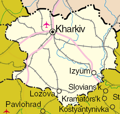
English: Map of en:Kharkiv Oblast, en:Ukraine
Adapted from http://www.un.org/Depts/Cartographic/map/profile/ukraine.pdf |
| Date | 13 Apryle 2005 (original upload date) |
| Soorce | Transferred from en.wikipedia to Commons by Drilnoth using CommonsHelper. |
| Author | The original uploader was ChrisO at Inglis Wikipaedia. |
Licensin
| This image is a map derived from a United Nations map.
Unless stated otherwise, UN maps are to be considered in the public domain. This applies worldwide. UN maps are, in principle, open source material and you can use them in your work or for making your own map. UN requests however that you delete the UN name, logo and reference number upon any modification to the map. Content of your map will be your responsibility. You can state in your publication, if you wish, something like: based on UN map … (map name, map number, revision number and date). See: Geospatial Information Section. And: Geospatial, location data for a better world. |
 |
Original upload log
- 2005-04-13 07:43 ChrisO 393×375× (24520 bytes) Map of [[Kharkivs'ka oblast']], [[Ukraine]]
File history
Clap oan ae date/time fer tae see the file aes it kithed at that time.
| Date/Time | Thummnail | Dimensions | Uiser | Comment | |
|---|---|---|---|---|---|
| current | 01:56, 31 Mairch 2009 | | 393 × 375 (24 KB) | File Upload Bot (Magnus Manske) | {{BotMoveToCommons|en.wikipedia|year={{subst:CURRENTYEAR}}|month={{subst:CURRENTMONTHNAME}}|day={{subst:CURRENTDAY}}}} {{Information |Description={{en|Map of en:Kharkiv Oblast, en:Ukraine Adapted from http://www.un.org/Depts/Cartographic/map/p |
Eimage airtins
The follaein pages airts tae this image:
Global file uisage
The follaein ither wikis uise this file:
- Uisage on en.wikipedia.org
- Uisage on eo.wikipedia.org
- Uisage on es.wikipedia.org
- Uisage on pt.wikipedia.org
- Uisage on ta.wikipedia.org
- Uisage on uk.wikisource.org
- Uisage on vi.wikipedia.org
- Uisage on www.wikidata.org