File:Ivano-Frankivsk province physical map.svg

Size of this PNG preview of this SVG file: 502 × 600 pixels. Ither resolutions: 201 × 240 pixels | 402 × 480 pixels | 643 × 768 pixels | 857 × 1,024 pixels | 1,714 × 2,048 pixels | 533 × 637 pixels.
Oreeginal file (SVG file, nominallie 533 × 637 pixels, file size: 1.21 MB)
Ootline
| Descreeption |
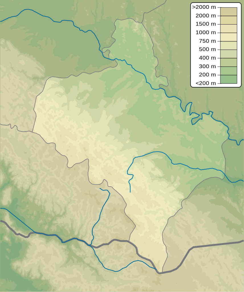
English: Physical map of Ivano-Frankivsk province, Ukraine
Русский: Физическая карта Ивано-Франковской области, Украина |
| Date | |
| Soorce | Ain wirk |
| Author | Urutseg |
Licensin
| I, the copyright holder of this work, release this work into the public domain. This applies worldwide. In some countries this may not be legally possible; if so: I grant anyone the right to use this work for any purpose, without any conditions, unless such conditions are required by law. |
File history
Clap oan ae date/time fer tae see the file aes it kithed at that time.
| Date/Time | Thummnail | Dimensions | Uiser | Comment | |
|---|---|---|---|---|---|
| current | 18:08, 10 December 2010 | | 533 × 637 (1.21 MB) | Urutseg | == {{int:filedesc}} == {{Information |Description={{en|1=Physical map of Ivano-Frankivsk province, Ukraine}} {{ru|1=Физическая карта Ивано-Франковской области, Украина}} |Source={{own}} |Author=[[User:Urutseg|U |
Eimage airtins
The follaein pages airts tae this image:
Global file uisage
The follaein ither wikis uise this file:
- Uisage on ar.wikipedia.org
- Uisage on be.wikipedia.org
- Uisage on bg.wikipedia.org
- Uisage on ceb.wikipedia.org
- Uisage on ce.wikipedia.org
- Uisage on da.wikipedia.org
- Uisage on de.wikipedia.org
- Uisage on en.wikipedia.org
- Ivano-Frankivsk International Airport
- Liubsha Air Base
- Module:Location map/data/Ukraine Ivano-Frankivsk Oblast/doc
- Zarosliak
- Sukil waterfalls
- Maniava waterfall
- Zhenetskyi Huk
- Bukhtivets
- Probiy
- Chernytskyi
- Brebeneskul
- Hutyn Tomnatyk
- Menchul
- Gwoździec Synagogue
- Module:Location map/data/Ukraine Ivano-Frankivsk Oblast
- Makovytsia
- Uisage on eo.wikipedia.org
- Uisage on es.wikipedia.org
- Uisage on fi.wikipedia.org
- Uisage on fr.wikipedia.org
View mair global usage o this file.