File:Isle of Skye UK location map.svg

Size of this PNG preview of this SVG file: 562 × 600 pixels. Ither resolutions: 225 × 240 pixels | 450 × 480 pixels | 719 × 768 pixels | 959 × 1,024 pixels | 1,919 × 2,048 pixels | 1,334 × 1,424 pixels.
Oreeginal file (SVG file, nominallie 1,334 × 1,424 pixels, file size: 1.56 MB)
| Descreeption |
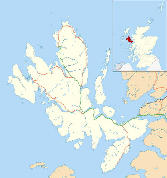
Blank map of the Isle of Skye, UK, as well as the adjacent islands, with the following information shown:
Equirectangular map projection on WGS 84 datum, with N/S stretched 180% Geographic limits:
|
| Date | |
| Soorce |
|
| Author | Nilfanion, created using Ordnance Survey data |
| Permission (Reuisin this file) |
This file is licensed unner the Creative Commons Attribution-Share Alike 3.0 Unported license. Attribution: Contains Ordnance Survey data © Crown copyright and database right
|
| Other versions | File:Isle of Skye UK blank map.svg - Blank map |
File history
Clap oan ae date/time fer tae see the file aes it kithed at that time.
| Date/Time | Thummnail | Dimensions | Uiser | Comment | |
|---|---|---|---|---|---|
| current | 11:20, 4 Februar 2011 | | 1,334 × 1,424 (1.56 MB) | Nilfanion | {{Information |Description=Blank map of the Isle of Skye, UK, as well as the adjacent islands, with the following information shown: *Coastline, lakes and rivers *Roads and railways *Urban areas Equirectangular map projection on WGS 84 |
Eimage airtins
The follaein pages airts tae this image:
Global file uisage
The follaein ither wikis uise this file:
- Uisage on ar.wikipedia.org
- Uisage on ceb.wikipedia.org
- Uisage on de.wikipedia.org
- Uisage on en.wikipedia.org
- Portree
- Armadale, Skye
- Dunvegan Castle
- Dunvegan
- Edinbane
- Ullinish
- Kyleakin
- Uig, Snizort
- Duntulm
- Struan, Skye
- Aird of Sleat
- Kylerhea
- Sligachan
- Broadford, Skye
- Isleornsay
- Tarskavaig
- Colbost
- Torrin
- Ose, Skye
- Upper Breakish
- Achachork
- Camasunary
- Boreraig
- Ardvasar
- Bornesketaig
- Borreraig
- Borrodale
- Ashaig
- Bracadale
- Kilmuir, Skye
- Mackinnon Memorial Hospital
- Uigshader
- Borve, Skye
- Trumpan
- Gillen, Skye
- Dun Ringill
- Kilmarie
- Heaste
- Lower Breakish
- Portnalong
- Camastianavaig
- Elgol
- Brogaig
- Bernisdale
- Idrigill
- Luib, Skye
- Lealt, Skye
View mair global usage o this file.