File:German postcode information.png

Size o this luikower: 445 × 600 pixels. Ither resolutions: 178 × 240 pixels | 356 × 480 pixels | 902 × 1,216 pixels.
Oreeginal file (902 × 1,216 pixels, file size: 80 KB, MIME type: image/png)
Ootline
| Descreeption |
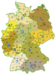
Deutsch: Karte der Postleitzahlen mit Zonen der ersten 2 Ziffern der PLZ und den Bundeslandgrenzen |
| Date | |
| Soorce | Ain wirk |
| Author | Stefan Kühn |

|
This locator map image could be re-created using vector graphics as an SVG file. This has several advantages; see Commons:Media for cleanup for more information. If an SVG form of this image is available, please upload it and afterwards replace this template with
{{vector version available|new image name}}.
It is recommended to name the SVG file “German postcode information.svg”—then the template Vector version available (or Vva) does not need the new image name parameter. |
Licensin
| This file is made available under the Creative Commons CC0 1.0 Universal Public Domain Dedication. | |
| The person who associated a work with this deed has dedicated the work to the public domain by waiving all of their rights to the work worldwide under copyright law, including all related and neighboring rights, to the extent allowed by law. You can copy, modify, distribute and perform the work, even for commercial purposes, all without asking permission.
|
File history
Clap oan ae date/time fer tae see the file aes it kithed at that time.
| Date/Time | Thummnail | Dimensions | Uiser | Comment | |
|---|---|---|---|---|---|
| current | 10:42, 12 Januar 2006 | | 902 × 1,216 (80 KB) | Eldred | *Beschreibung: **Karte der Postleitzahlen mit Zonen der ersten 2 Ziffern der PLZ und den Bundeslandgrenzen *Quelle: **Erstellt am 18. Juni 2003 *Fotograf oder Zeichner: **Stefan Kühn *Copyright Status: {{GFDL}} |
Eimage airtins
The'r nae pages airts tae this eimage.
Global file uisage
The follaein ither wikis uise this file:
- Uisage on als.wikipedia.org
- Uisage on av.wikipedia.org
- Uisage on da.wikipedia.org
- Uisage on de.wikipedia.org
- Postleitzahl (Deutschland)
- Portal:Postgeschichte
- Benutzer Diskussion:Stefan Kühn/Archiv/2008/Nov
- Liste der Postleitregionen in Deutschland
- Postleitzahlenkarte
- Diskussion:Liste der Postleitregionen in Deutschland
- Postgeschichte von Steinfurt
- Portal:Postgeschichte/Artikel des Monats
- Wikipedia Diskussion:Hauptseite/Artikel des Tages/Archiv/Vorschläge/2010/2
- Wikipedia Diskussion:Hauptseite/Artikel des Tages/Archiv/Vorschläge/2013/Q3
- Wikipedia:Hauptseite/Archiv/1. Juli 2013
- Benutzer Diskussion:Stefan Kühn/Archiv/2016
- Wikipedia:Auskunft/Archiv/2016/Woche 12
- Wikipedia:Kartenwerkstatt/Archiv/Zurückgewiesene und zurückgestellte Aufträge 2017
- Wikipedia:Dresden/Archiv/2013
- Uisage on en.wikipedia.org
- Uisage on es.wikipedia.org
- Uisage on fa.wikipedia.org
- Uisage on fr.wikipedia.org
- Uisage on he.wikipedia.org
- Uisage on hsb.wikipedia.org
- Uisage on hu.wikipedia.org
- Uisage on id.wikipedia.org
- Uisage on ja.wikipedia.org
- Uisage on nl.wikipedia.org
- Uisage on nl.wikibooks.org
- Uisage on os.wikipedia.org
- Uisage on pfl.wikipedia.org
- Uisage on pl.wikipedia.org
- Uisage on ru.wikipedia.org
- Uisage on simple.wikipedia.org
- Uisage on szl.wikipedia.org
- Uisage on tt.wikipedia.org
- Uisage on zh.wikipedia.org