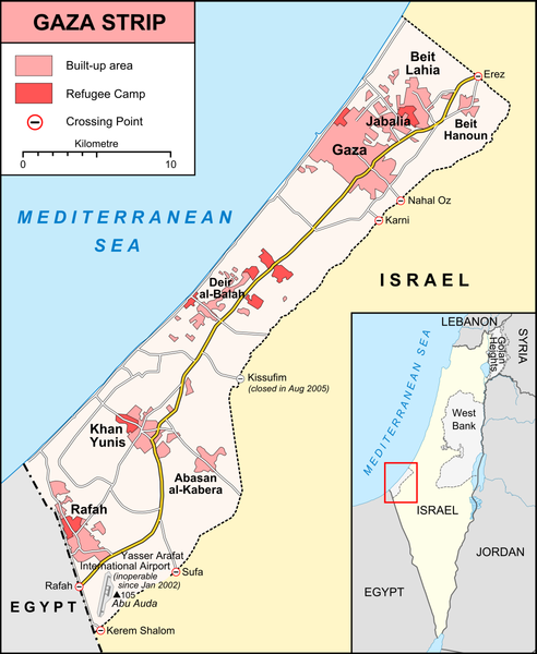
File:Gaza Strip map.png

Size o this luikower: 492 × 600 pixels. Ither resolutions: 197 × 240 pixels | 394 × 480 pixels | 984 × 1,200 pixels.
Oreeginal file (984 × 1,200 pixels, file size: 343 KB, MIME type: image/png)
File history
Clap oan ae date/time fer tae see the file aes it kithed at that time.
| Date/Time | Thummnail | Dimensions | Uiser | Comment | |
|---|---|---|---|---|---|
| current | 20:42, 6 Januar 2009 |  | 984 × 1,200 (343 KB) | Lencer | {{Information |Description= |Source= |Date= |Author= |Permission= |other_versions= }} |
| 20:06, 6 Januar 2009 |  | 984 × 1,200 (343 KB) | Lencer | {{Information| |Description=Map of Gaza Strip, Stand December 2008 |Source=own work, used: * [http://unosat.web.cern.ch/unosat/asp/prod_free.asp?pid=1304 UNOSAT, Situation Map-Gaza Crisis] * [http://www.ochaopt.org/gazacrisis/admin/outp |
Eimage airtins
The'r nae pages airts tae this eimage.
Global file uisage
The follaein ither wikis uise this file:
- Uisage on be.wikipedia.org
- Uisage on da.wikipedia.org
- Uisage on de.wikipedia.org
- Uisage on de.wikinews.org
- Uisage on en.wikipedia.org
- Uisage on fr.wikipedia.org
- Uisage on hy.wikipedia.org
- Uisage on li.wikinews.org
- Uisage on no.wikipedia.org
- Uisage on ru.wikipedia.org
- Uisage on sv.wikipedia.org
- Uisage on tt.wikipedia.org
- Uisage on vep.wikipedia.org


