File:Egypt 1450 BC.svg

Size of this PNG preview of this SVG file: 520 × 600 pixels. Ither resolutions: 208 × 240 pixels | 416 × 480 pixels | 666 × 768 pixels | 887 × 1,024 pixels | 1,775 × 2,048 pixels | 1,300 × 1,500 pixels.
Oreeginal file (SVG file, nominallie 1,300 × 1,500 pixels, file size: 257 KB)
Ootline
| Descreeption |
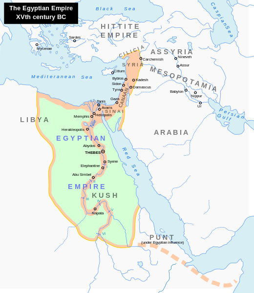
English: Map of the Middle East 1450 BC (by ArdadN)
Čeština: Největší územní rozsah starověkého Egypta, za vlády Thutmose I. |
| Soorce |
The original description page was here. All following user names refer to en.wikipedia.
|
| Author | ArdadN at Inglis Wikipaedia |
| Other versions |
[]
|


|
This SVG file contains embedded text that can be translated into your language, using any capable SVG editor, text editor or the SVG Translate tool. For more information see: About translating SVG files. |
Licensin
| I, the copyright holder of this work, release this work into the public domain. This applies worldwide. In some countries this may not be legally possible; if so: I grant anyone the right to use this work for any purpose, without any conditions, unless such conditions are required by law. |
File history
Clap oan ae date/time fer tae see the file aes it kithed at that time.
| Date/Time | Thummnail | Dimensions | Uiser | Comment | |
|---|---|---|---|---|---|
| current | 22:18, 23 September 2023 | | 1,300 × 1,500 (257 KB) | Gaaryeelidmaan | Punt was associated with Myrrh trade, a product found in modern Puntland https://www.worldhistory.org/punt/ |
| 05:28, 9 October 2013 |  | 1,300 × 1,500 (257 KB) | Lymantria | Reverted to version as of 00:24, 10 August 2008 | |
| 16:05, 7 October 2013 |  | 1,300 × 1,500 (238 KB) | Emara | تعريب الخريطة | |
| 00:24, 10 August 2008 |  | 1,300 × 1,500 (257 KB) | Leoboudv | {{Information |Description=Map of the Middle East 1450 BC |Source=The original description page is/was [http://en.wikipedia.org/w/index.php?title=Image%3AEgypt_1450_BC.svg here]. All following user names refer to en.wikipedia. * 2008-05-07 09:18 [[:en:Use |
Eimage airtins
The'r nae pages airts tae this eimage.
Global file uisage
The follaein ither wikis uise this file:
- Uisage on ast.wikipedia.org
- Uisage on azb.wikipedia.org
- Uisage on az.wikipedia.org
- Uisage on ba.wikipedia.org
- Uisage on be.wikipedia.org
- Uisage on bg.wikipedia.org
- Uisage on bn.wikipedia.org
- Uisage on ca.wikipedia.org
- Uisage on cv.wikipedia.org
- Uisage on de.wikipedia.org
- Uisage on el.wikipedia.org
- Uisage on en.wikipedia.org
- Timeline of Jerusalem
- Thutmose I
- The Bible Unearthed
- List of conflicts in Asia
- Middle Eastern empires
- List of conflicts in Egypt
- Land of Punt
- Transjordan (region)
- List of conflicts in Sudan
- List of conflicts in Libya
- User:Falcaorib
- Talk:The Exodus/Archive 18
- User:SomeGuyWhoRandomlyEdits/List of conflicts in the Near East
- Uisage on eu.wikipedia.org
- Uisage on fa.wikipedia.org
- Uisage on gl.wikipedia.org
- Uisage on hi.wikipedia.org
- Uisage on hy.wikipedia.org
- Uisage on hyw.wikipedia.org
- Uisage on id.wikipedia.org
- Uisage on id.wikibooks.org
- Uisage on is.wikipedia.org
- Uisage on it.wikipedia.org
- Uisage on ja.wikipedia.org
View mair global usage o this file.