File:Dingo-Distribution-Fleming.png
Size o this luikower: 800 × 486 pixels. Ither resolutions: 320 × 194 pixels | 640 × 389 pixels | 1,024 × 622 pixels | 1,280 × 778 pixels | 2,150 × 1,306 pixels.
Oreeginal file (2,150 × 1,306 pixels, file size: 901 KB, MIME type: image/png)

|
This map image could be re-created using vector graphics as an SVG file. This has several advantages; see Commons:Media for cleanup for more information. If an SVG form of this image is available, please upload it and afterwards replace this template with
{{vector version available|new image name}}.
It is recommended to name the SVG file “Dingo-Distribution-Fleming.svg”—then the template Vector version available (or Vva) does not need the new image name parameter. |
Ootline
| Descreeption |
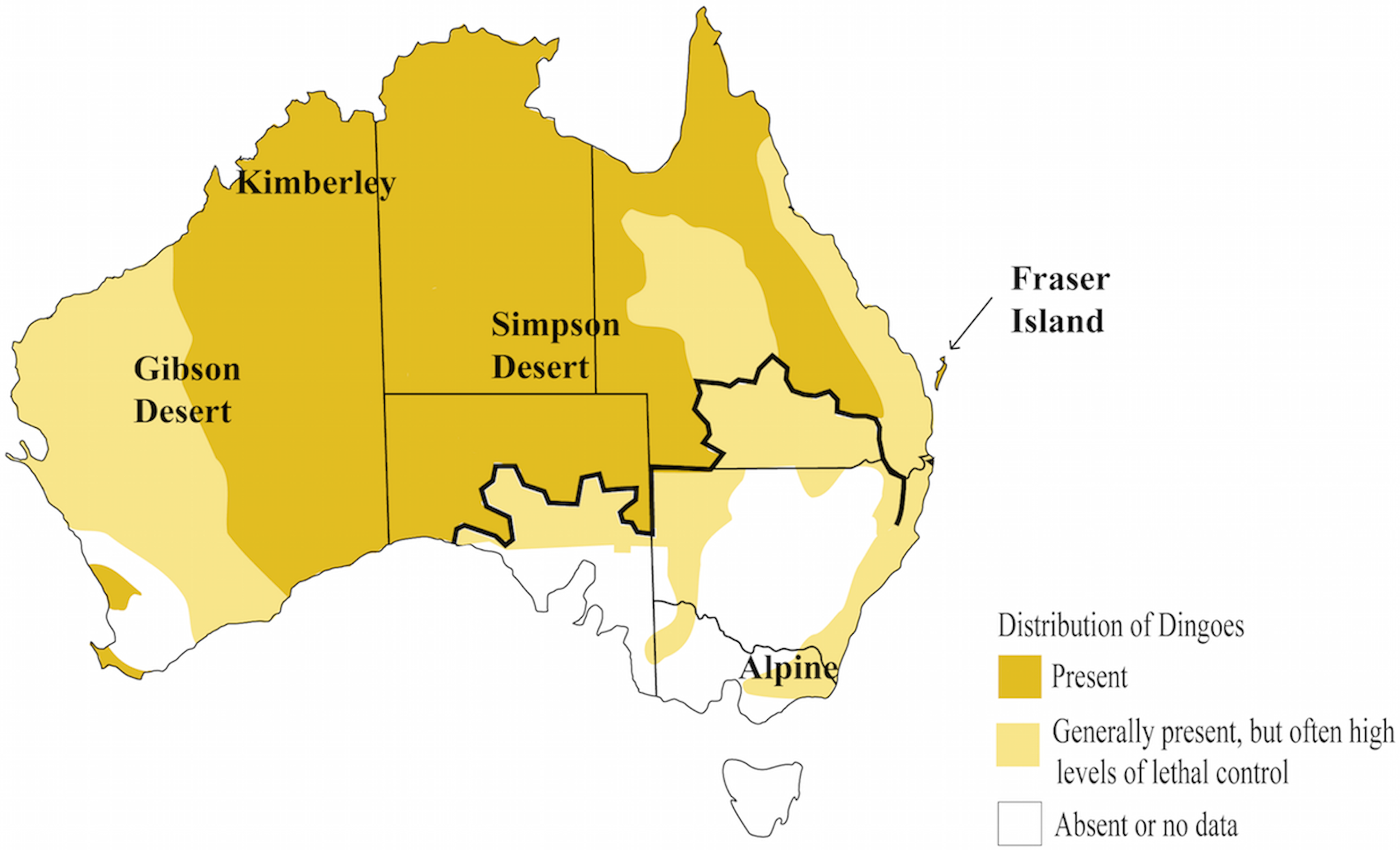
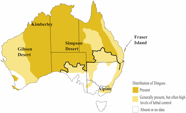
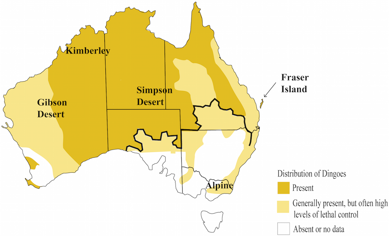
English: Distribution of the dingo |
| Date | |
| Soorce | Elucidating biogeographical patterns in Australian native canids using genome wide SNPs Cairns et al 2019, who compiled maps from Fleming 2001 and 2014. |
| Author | User:William Harris |
| Permission (Reuisin this file) |
Open access |
| Other versions |
Licensin
This file is licensed under the Creative Commons Attribution-Share Alike 4.0 International license.
Attribution: International
- Ye are free:
- tae share – tae copy, distribute an transmit the wirk
- tae remix – tae adapt the wirk
- Unner the follaein condeetions:
- attribution – Ye must attribute the wirk in the manner specified bi the author or licensor (but nae in ony way that suggests that thay endorse ye or yer uise o the wirk).
- share alik – If ye alter, transform, or big upon this wirk, ye mey distribute the resultin wirk anly unner the same or seemilar license tae this ane.
File history
Clap oan ae date/time fer tae see the file aes it kithed at that time.
| Date/Time | Thummnail | Dimensions | Uiser | Comment | |
|---|---|---|---|---|---|
| current | 10:33, 9 Mey 2020 | | 2,150 × 1,306 (901 KB) | William Harris | Updated for "Elucidating biogeographical patterns in Australian native canids using genome wide SNPs", Cairns et al 2018. Map compiled from Fleming 2001 and Fleming 2014. |
| 16:20, 27 Mey 2009 |  | 444 × 363 (18 KB) | Inugami-bargho | {{Information |Description={{en|1=possible distribution of the Australian Dingo}} |Source=drawn after a map in [http://www.nt.gov.au/nreta/wildlife/programs/pdf/dingo_management.pdf A MANAGEMENT PROGRAM FOR THE DINGO (Canis lupus dingo) IN THE NORD-TERRIT |
Eimage airtins
The follaein pages airts tae this image:
Global file uisage
The follaein ither wikis uise this file:
- Uisage on avk.wikipedia.org
- Uisage on ban.wikipedia.org
- Uisage on bg.wikipedia.org
- Uisage on ca.wikipedia.org
- Uisage on cs.wikipedia.org
- Uisage on en.wikipedia.org
- Uisage on eo.wikipedia.org
- Uisage on es.wikipedia.org
- Uisage on eu.wikipedia.org
- Uisage on ga.wikipedia.org
- Uisage on gl.wikipedia.org
- Uisage on he.wikipedia.org
- Uisage on hi.wikipedia.org
- Uisage on hu.wikipedia.org
- Uisage on incubator.wikimedia.org
- Uisage on is.wikipedia.org
- Uisage on it.wikipedia.org
- Uisage on ja.wikipedia.org
- Uisage on ko.wikipedia.org
- Uisage on la.wikipedia.org
- Uisage on ms.wikipedia.org
- Uisage on my.wikipedia.org
- Uisage on no.wikipedia.org
- Uisage on pt.wikipedia.org
- Uisage on ro.wikipedia.org
- Uisage on simple.wikipedia.org
- Uisage on tr.wikipedia.org
- Uisage on vi.wikipedia.org
- Uisage on www.wikidata.org
- Uisage on zh-min-nan.wikipedia.org
- Uisage on zh.wikipedia.org