File:Carte topographique des Vosges.svg

Size of this PNG preview of this SVG file: 398 × 600 pixels. Ither resolutions: 159 × 240 pixels | 318 × 480 pixels | 509 × 768 pixels | 679 × 1,024 pixels | 1,358 × 2,048 pixels | 1,271 × 1,916 pixels.
Oreeginal file (SVG file, nominallie 1,271 × 1,916 pixels, file size: 4.01 MB)
Ootline
| Descreeption |
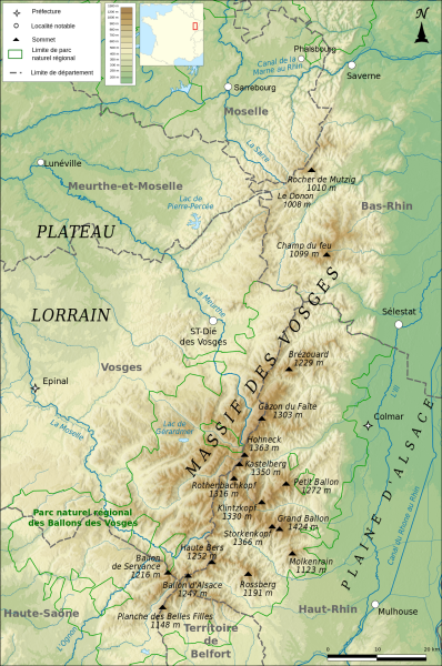
Français : Carte topographique des Vosges |
| Date | |
| Soorce |
Ain wirk Relief : SRTM3 v2 Limites départementales : IGN-GEOFLA®
Minicarte : Blank map of Europe par Historicair Projection : Lambert 93 |
| Author | Boldair |
| Other versions |
|

Licensin
I, the copyright holder of this work, hereby publish it under the following license:
This file is licensed under the Creative Commons Attribution-Share Alike 4.0 International license.
- Ye are free:
- tae share – tae copy, distribute an transmit the wirk
- tae remix – tae adapt the wirk
- Unner the follaein condeetions:
- attribution – Ye must attribute the wirk in the manner specified bi the author or licensor (but nae in ony way that suggests that thay endorse ye or yer uise o the wirk).
- share alik – If ye alter, transform, or big upon this wirk, ye mey distribute the resultin wirk anly unner the same or seemilar license tae this ane.
File history
Clap oan ae date/time fer tae see the file aes it kithed at that time.
| Date/Time | Thummnail | Dimensions | Uiser | Comment | |
|---|---|---|---|---|---|
| current | 11:43, 11 Januar 2016 | | 1,271 × 1,916 (4.01 MB) | Niko67000 | ajout de Sarrebourg, Phalsbourg et du Donon. |
| 08:36, 14 Januar 2015 |  | 1,271 × 1,916 (5.99 MB) | Boldair | meilleur relief | |
| 08:34, 14 Januar 2015 |  | 1,271 × 1,916 (5.99 MB) | Boldair | meilleur relief | |
| 21:05, 8 Januar 2015 |  | 1,271 × 1,916 (5.2 MB) | Boldair | allegement fichier | |
| 14:33, 8 Januar 2015 |  | 1,271 × 1,916 (6.11 MB) | Boldair | legende | |
| 14:04, 8 Januar 2015 |  | 1,271 × 1,916 (6.11 MB) | Boldair | Relief plus vert pour mieux faire apparaître les contours du massif | |
| 20:20, 7 Januar 2015 |  | 1,271 × 1,916 (5.44 MB) | Boldair | + un sommet | |
| 10:23, 7 Januar 2015 |  | 1,271 × 1,916 (5.44 MB) | Boldair | rectif | |
| 09:12, 7 Januar 2015 |  | 1,271 × 1,916 (5.44 MB) | Boldair | ajout minicarte | |
| 09:07, 7 Januar 2015 |  | 1,271 × 1,916 (5.42 MB) | Boldair | Rectif légende |
Eimage airtins
The'r nae pages airts tae this eimage.
Global file uisage
The follaein ither wikis uise this file:
- Uisage on af.wikipedia.org
- Uisage on als.wikipedia.org
- Uisage on an.wikipedia.org
- Uisage on be.wikipedia.org
- Uisage on cs.wikipedia.org
- Uisage on de.wikipedia.org
- Uisage on el.wikipedia.org
- Uisage on en.wikipedia.org
- Uisage on eo.wikipedia.org
- Uisage on es.wikipedia.org
- Uisage on fa.wikipedia.org
- Uisage on fi.wikipedia.org
- Uisage on fr.wikipedia.org
- Uisage on he.wikipedia.org
- Uisage on hu.wikipedia.org
- Uisage on id.wikipedia.org
- Uisage on it.wikipedia.org
- Uisage on ja.wikipedia.org
- Uisage on ko.wikipedia.org
- Uisage on nl.wikipedia.org
- Uisage on pl.wikipedia.org
- Uisage on pl.wikivoyage.org
- Uisage on ro.wikipedia.org
- Uisage on sh.wikipedia.org
- Uisage on sk.wikipedia.org
- Uisage on th.wikipedia.org
- Uisage on uk.wikipedia.org
- Uisage on zh.wikipedia.org