File:Badghis districts.png

Size o this luikower: 800 × 548 pixels. Ither resolutions: 320 × 219 pixels | 640 × 439 pixels | 960 × 658 pixels.
Oreeginal file (960 × 658 pixels, file size: 16 KB, MIME type: image/png)

|
This map image could be re-created using vector graphics as an SVG file. This has several advantages; see Commons:Media for cleanup for more information. If an SVG form of this image is available, please upload it and afterwards replace this template with
{{vector version available|new image name}}.
It is recommended to name the SVG file “Badghis districts.svg”—then the template Vector version available (or Vva) does not need the new image name parameter. |
Ootline
| Descreeption |
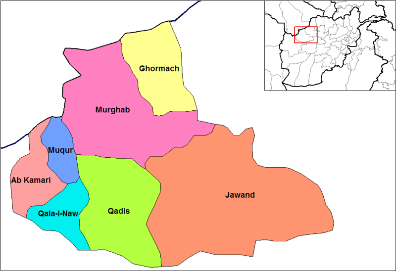
English: Map of the districts of Badghis province of Afghanistan. Created by Rarelibra 19:19, 29 March 2007 (UTC) for public domain use, using MapInfo Professional v8.5 and various mapping resources. |
| Date | 29 Mairch 2007 (original upload date) |
| Soorce | No machine-readable source provided. Own work assumed (based on copyright claims). |
| Author | No machine-readable author provided. Rarelibra assumed (based on copyright claims). |
Licensin
| I, the copyright holder of this work, release this work into the public domain. This applies worldwide. In some countries this may not be legally possible; if so: I grant anyone the right to use this work for any purpose, without any conditions, unless such conditions are required by law. |
File history
Clap oan ae date/time fer tae see the file aes it kithed at that time.
| Date/Time | Thummnail | Dimensions | Uiser | Comment | |
|---|---|---|---|---|---|
| current | 13:39, 15 Februar 2024 | | 960 × 658 (16 KB) | User-duck | Cropped 9 % horizontally, 19 % vertically using CropTool with lossless mode. |
| 19:19, 29 Mairch 2007 |  | 1,056 × 816 (25 KB) | Rarelibra | Map of the districts of Badghis province of Afghanistan. Created by ~~~~ for public domain use, using MapInfo Professional v8.5 and various mapping resources. |
Eimage airtins
The follaein pages airts tae this image:
Global file uisage
The follaein ither wikis uise this file:
- Uisage on ar.wikipedia.org
- Uisage on az.wikipedia.org
- Uisage on bn.wikipedia.org
- Uisage on ca.wikipedia.org
- Uisage on ceb.wikipedia.org
- Uisage on ckb.wikipedia.org
- Uisage on de.wikipedia.org
- Uisage on en.wikipedia.org
- Uisage on es.wikipedia.org
- Uisage on fa.wikipedia.org
- Uisage on fr.wikipedia.org
- Uisage on he.wikipedia.org
- Uisage on id.wikipedia.org
- Uisage on incubator.wikimedia.org
- Uisage on it.wikipedia.org
- Uisage on ja.wikipedia.org
- Uisage on lt.wikipedia.org
- Uisage on ml.wikipedia.org
- Uisage on mn.wikipedia.org
- Uisage on ms.wikipedia.org
- Uisage on nl.wikipedia.org
- Uisage on no.wikipedia.org
- Uisage on pl.wikipedia.org
- Uisage on pnb.wikipedia.org
- Uisage on ps.wikipedia.org
- Uisage on pt.wikipedia.org
- Uisage on ru.wikipedia.org
- Uisage on sd.wikipedia.org
- Uisage on simple.wikipedia.org
- Uisage on sk.wikipedia.org
- Uisage on ta.wikipedia.org
- Uisage on th.wikipedia.org
- Uisage on tr.wikipedia.org
- Uisage on uk.wikipedia.org
- Uisage on ur.wikipedia.org
- Uisage on uz.wikipedia.org
- Uisage on vi.wikipedia.org
View mair global usage o this file.