File:Aral Sea.gif
Size o this luikower: 410 × 600 pixels. Ither resolutions: 164 × 240 pixels | 560 × 819 pixels.
Oreeginal file (560 × 819 pixels, file size: 465 KB, MIME type: image/gif, luip't, 8 frames, 15 s)
Ootline
| Descreeption |
Deutsch: Animierte Karte des Austrocknens des Aralsees, englische Version
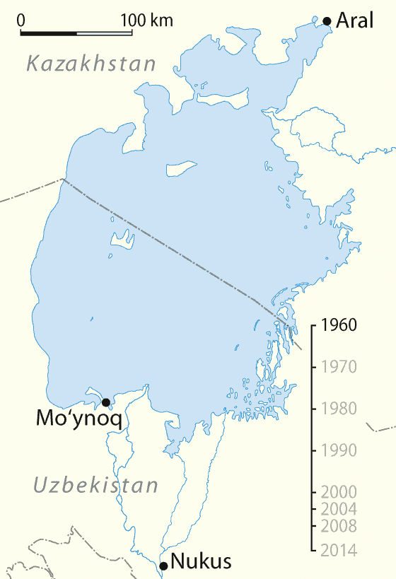
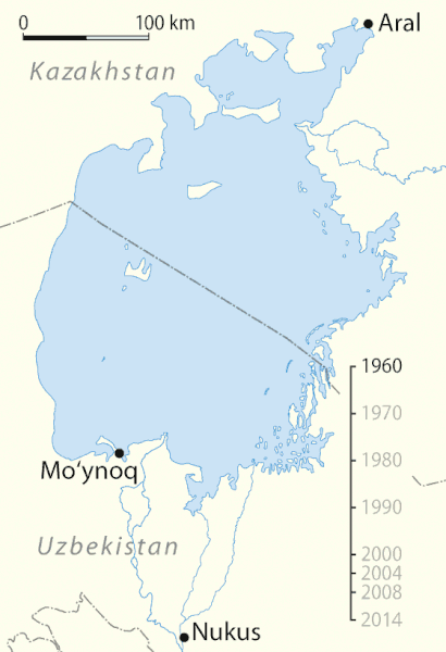
English: Animated map of the shrinking of the Aral Sea, English Version
Español: Mapa animado del cambio del Mar de Aral, versión inglés
Français : Animation de l'assèchement de la Mer d'Aral entre 1960 et 2014. version anglaise
Русский: Снижение уровня Аральского моря
Čeština: Vysychání (zmenšování plochy) Aralského jezera v období let 1960 - 2014.
العربية: البيان الزمني لتقلص بحر آرال.
Эрзянь: Аралонь иневедень ёмавтомась-вишкалговтомась шкасо. |
| Date | 01-05-2008 |
| Soorce |
Own work using:
|
| Author | NordNordWest |
| Other versions |
|
Assessment
| This file was selected as the media of the day for 5 January 2021. It was captioned as follows:
English: Aral Sea, timeline of shrinking.
Other languages
العربية: البيان الزمني لتقلص بحر آرال. Čeština: Vysychání (zmenšování plochy) Aralského jezera v období let 1960 - 2014. English: Aral Sea, timeline of shrinking. Français : Animation de l'assèchement de la mer d'Aral entre 1960 et 2014. Эрзянь: Аралонь иневедень ёмавтомась-вишкалговтомась шкасо. Русский: Снижение уровня Аральского моря
|

|
This map has been made or improved in the German Kartenwerkstatt (Map Lab). You can propose maps to improve as well.
|
Licensin
I, the copyright holder of this work, hereby publish it under the following licenses:

|
Permission is grantit tae copy, distribute an/or modify this document unner the terms o the GNU Free Documentation License, Version 1.2 or ony later version published bi the Free Software Foundation; wi no Invariant Sections, no Front-Cover Texts, an no Back-Cover Texts. A copy o the license is includit in the section enteetled GNU Free Documentation License. |
This file is licensed unner the Creative Commons Attribution-Share Alike 3.0 Unported license.
- Ye are free:
- tae share – tae copy, distribute an transmit the wirk
- tae remix – tae adapt the wirk
- Unner the follaein condeetions:
- attribution – Ye must attribute the wirk in the manner specified bi the author or licensor (but nae in ony way that suggests that thay endorse ye or yer uise o the wirk).
- share alik – If ye alter, transform, or big upon this wirk, ye mey distribute the resultin wirk anly unner the same or seemilar license tae this ane.
Ye mey select the license o yer choice.
File history
Clap oan ae date/time fer tae see the file aes it kithed at that time.
| Date/Time | Thummnail | Dimensions | Uiser | Comment | |
|---|---|---|---|---|---|
| current | 14:55, 30 Apryle 2020 | | 560 × 819 (465 KB) | Palosirkka | size optimized with the GIMP |
| 20:13, 12 Januar 2016 |  | 560 × 819 (534 KB) | Rwxrwxrwx | added 2014 frame | |
| 18:41, 7 Januar 2009 |  | 560 × 819 (479 KB) | Hk kng | Size optimization | |
| 15:36, 1 Mey 2008 |  | 560 × 819 (1.05 MB) | NordNordWest | {{Information |Description= {{de}} Animierte Karte des Austrocknens des Aralsees, englische Version {{en}} Animated map of the shrinking of the Aral Sea, English Version {{es}} Mapa animado del cambio del [[:es:Mar de Ara |
Eimage airtins
The follaein pages airts tae this image:
Global file uisage
The follaein ither wikis uise this file:
- Uisage on af.wikipedia.org
- Uisage on am.wikipedia.org
- Uisage on ban.wikipedia.org
- Uisage on bat-smg.wikipedia.org
- Uisage on ba.wikipedia.org
- Баш бит
- Ҡатнашыусы:Регион102/Баш бит
- Ҡатнашыусы:Регион102/Баш бит/Ҡыҙыҡ мәғлүмәт
- Ҡалып:Беләһеңме
- Ҡалып:Ҡыҙыҡ мәғлүмәт
- Википедия:Ҡыҙыҡ мәғлүмәт
- Википедия:Ҡыҙыҡ мәғлүмәт/Тәҡдим
- Ҡатнашыусы:Регион102/Баш бит2
- Ҡатнашыусы:Регион102/Баш бит2/Ҡыҙыҡ мәғлүмәт
- Ҡатнашыусы:Регион102/Баш бит3
- Ҡатнашыусы:Регион102/Баш бит4
- Ҡатнашыусы:Регион102/Баш бит5
- Ҡатнашыусы:Регион102/Баш бит5.2
- Ҡатнашыусы:Регион102/Баш бит6
- Ҡатнашыусы:Регион102/Баш бит6.2
- Ҡатнашыусы:Регион102/Баш бит5.3
- Арал диңгеҙе
- Ҡатнашыусы:Рөстәм Нурыев/Баш бит
- Ҡатнашыусы:Рөстәм Нурыев/Баш бит 1
- Арал диңгеҙенең кимәле кәмеүе
- Ҡатнашыусы:ZUFAr/Баш бит
- Uisage on be-tarask.wikipedia.org
- Uisage on be.wikipedia.org
- Uisage on bg.wikipedia.org
- Uisage on bh.wikipedia.org
- Uisage on bn.wikipedia.org
- Uisage on bs.wikipedia.org
- Uisage on bxr.wikipedia.org
- Uisage on ca.wikipedia.org
- Uisage on cdo.wikipedia.org
- Uisage on ceb.wikipedia.org
- Uisage on ckb.wikipedia.org
- Uisage on cs.wikipedia.org
- Uisage on cv.wikipedia.org
- Uisage on cy.wikipedia.org
- Uisage on da.wikipedia.org
- Uisage on de.wikipedia.org
- Uisage on dsb.wikipedia.org
- Uisage on el.wikipedia.org
- Uisage on en.wikipedia.org
View mair global usage o this file.