File:Çanakkale districts.png

Size o this luikower: 776 × 600 pixels. Ither resolutions: 311 × 240 pixels | 621 × 480 pixels | 994 × 768 pixels | 1,056 × 816 pixels.
Oreeginal file (1,056 × 816 pixels, file size: 43 KB, MIME type: image/png)
Ootline
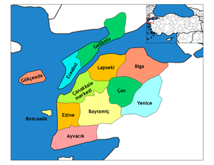
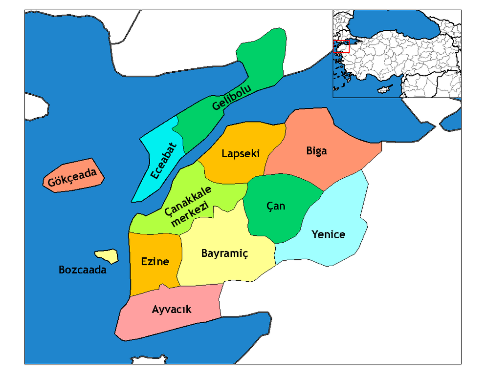
| Descreeption | Map of the districts of Canakkale province in Turkey. Created by Rarelibra 19:28, 1 December 2006 (UTC) for public domain use, using MapInfo Professional v8.5 and various mapping resources. Edited by One Homo Sapiens Corrected text where İ,Ş,ı,ğ,or ş occurs in name. Source: [statoids-com]. Increased font size and enhanced color differences among adjacent districts. |
| Date | 31 Mairch 2007 (original upload date) |
| Soorce | No machine-readable source provided. Own work assumed (based on copyright claims). |
| Author | No machine-readable author provided. Denizz~commonswiki assumed (based on copyright claims). |
Licensin
| I, the copyright holder of this work, release this work into the public domain. This applies worldwide. In some countries this may not be legally possible; if so: I grant anyone the right to use this work for any purpose, without any conditions, unless such conditions are required by law. |
File history
Clap oan ae date/time fer tae see the file aes it kithed at that time.
| Date/Time | Thummnail | Dimensions | Uiser | Comment | |
|---|---|---|---|---|---|
| current | 04:22, 29 December 2008 | | 1,056 × 816 (43 KB) | One Homo Sapiens | Corrected text where İ,Ş,ı,ğ,or ş occurs in name. Source: [statoids-com]. Increased font size and enhanced color differences among adjacent districts. |
| 15:47, 12 Apryle 2007 |  | 776 × 600 (110 KB) | KureCewlik81 | ||
| 07:01, 31 Mairch 2007 |  | 1,056 × 816 (33 KB) | Denizz~commonswiki | == Summary == Map of the districts of Canakkale province in Turkey. Created by Rarelibra 19:28, 1 December 2006 (UTC) for public domain use, using MapInfo Professional v8.5 and various mapping resources. == Licensing == {{PD-self}} <!- |
Eimage airtins
The follaein pages airts tae this image:
Global file uisage
The follaein ither wikis uise this file:
- Uisage on ast.wikipedia.org
- Uisage on azb.wikipedia.org
- Uisage on ba.wikipedia.org
- Uisage on bg.wikipedia.org
- Uisage on ca.wikipedia.org
- Uisage on ceb.wikipedia.org
- Uisage on ce.wikipedia.org
- Uisage on cs.wikipedia.org
- Uisage on de.wikipedia.org
- Uisage on diq.wikipedia.org
- Uisage on el.wikipedia.org
- Uisage on en.wikipedia.org
- Imbros
- Çanakkale Province
- User talk:Rarelibra/Maps4
- Gökçeada District
- List of populated places in Çanakkale Province
- Districts of Turkey
- Akbaş arms depot raid
- Bozcaada, Çanakkale
- Governor of Çanakkale
- Gelibolu District
- Ayvacık District, Çanakkale
- Bayramiç District
- Biga District
- Çan District
- Çanakkale District
- Eceabat District
- Ezine District
- Lapseki District
View mair global usage o this file.