Drysal
Drysal[1] (English: Dryfesdale (/ˈdraɪfsdeɪl/)[2] ) is a ceevil pairish in the historical coonty o Dumfriesshire in Dumfries an Gallowa, Scotland.


Owerview
eeditThe pairish kirk o Drysal, locatit in the centre o Lockerbie, wis dedicatit tae Saunt Cutbear (Cuthbert). In 1116 it belangt til the See o Gallowa.[3]
The ceevil pairish o Drysal includes the toun o Lockerbie that has apparent existit syne the daays o Viking influence in this pairt o Scotland in the speal aroond 900 AD (CE). The name o Lockerbie means Lockard's ferm in the Auld Norse leid. The presence o the remeens o a Roman camp ae mile til the wast o the toun suggests its oreegins micht hae been even earlier. Lockerbie first entert recordit history as Lokardebi in 1306.
Strang auld tours wis at Netherplace, Auld Waws, Kirktoun Mains, Myreheid, and Daltonheuk.
Remeens o aicht camps, some square or Roman, ithers circular o Caledonian, occur in different places, maistly on hilltaps. Twa o thaim, Roman an Caledonian, face ilk ither on hills til the nor'east o Bengall veelage.[4]
Pan Am Flicht 103
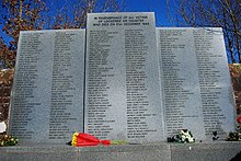
eeditDrysal Seemetry haes the main UK memorial til the veectims o the bombin o Pan Am Flicht 103 that occurt on 21 December 1988 ower the toun o Lockerbie. Thare is a semi-circular stane waw in the Gairden o Rememberance wi the names an nationalitys o aw the veectims alang wi individual funeral stanes an memorials. Inside the chaipel thare is a beuk o rememberance.
Reference
eedit- ↑ The Imperial gazetteer of Scotland. 1854. Vol.I. (AAN-GORDON) by Rev. John Marius Wilson. pp.404-405
- ↑ Template:Cite EPD
- ↑ "Infos at canmore.rcahms.gov.uk". Archived frae the original on 18 Mey 2015. Retrieved 9 Apryle 2020.
- ↑ Parish of Dryfesdale
External links
eedit| Wikimedia Commons haes media relatit tae Dryfesdale. |
- Ceevil Pairish Map o Dumfriesshire, shawin the Ceevil Pairish o Drysal in Dumfriesshire within the Destrict Cooncil Region o Dumfries an Gallowa
- Popular Rymes. pub. 1842 bi William an Robert Chambers. pp.10-11
Coordinates: 55°07′12″N 3°21′25″W / 55.120°N 3.357°W
| This Places o Scotland airticle is a stub. Ye can help Wikipaedia bi expandin it. |