Arunachal Pradesh
Arunachal Pradesh /ˌɑːrəˌnɑːtʃəl prəˈdɛʃ/ is ane o the 28 states o Indie. Locatit in northeast Indie, Arunachal Pradesh borders the states o Assam an Nagaland tae the sooth, an shares internaitional borders wit Bhutan in the wast, Myanmar in the east an the Fowkrepublic o Cheenae in the north. Itanagar is the caipital o the state. Cheenae an ROC claim maist o the state as pairt o Tibet an cry the disputit aurie Sooth Tibet.[2]
Arunachal Pradesh | |
|---|---|
 Location o Arunachal Pradesh in Indie | |
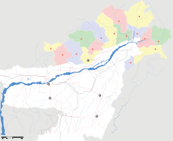
 Cairt o Arunachal Pradesh | |
| Coordinates (Itanagar): 27°04′N 93°22′E / 27.06°N 93.37°ECoordinates: 27°04′N 93°22′E / 27.06°N 93.37°E | |
| Kintra | Indie (de facto) |
| Established | 20 Februar 1987 |
| Capital | Itanagar |
| Lairgest ceety | Itanagar |
| Destricts | 16 |
| Govrenment | |
| • Govrenor | Nirbhay Sharma |
| • Chief Meenister | Nabam Tuki (INC) |
| • Legislatur | Unicameral (60 seats) |
| • Pairliamentary constituency | 2 |
| • Heich Coort | Guwahati Heicg Coort – Itanagar Bench |
| Area | |
| • Total | 83743 km2 (32,333 sq mi) |
| Area rank | 14t |
| Population (2011) | |
| • Total | 1,382,611 |
| • Rank | 26t |
| • Density | 17/km2 (43/sq mi) |
| Time zone | UTC+05:30 (IST) |
| ISO 3166 code | IN-AR |
| HDI | |
| HDI rank | 18t (2005) |
| Leeteracy | 66.95% |
| Offeecial leids | Inglis[1] |
| Website | arunachalpradesh |
References
eedit- ↑ "Report of the Commissioner for linguistic minorities: 47th report (July 2008 to June 2010)" (PDF). Commissioner for Linguistic Minorities, Ministry of Minority Affairs, Government of India. pp. 122–126. Archived frae the original (PDF) on 13 Mey 2012. Retrieved 16 Februar 2012.
- ↑ Wirsing, Robert G.; Christopher Jasparro; Daniel C. Stoll (2012). "Source of Transboundary River Disputes". International Conflict Over Water Resources in Himalayan Asia. Palgrave Macmillan. p. 103. ISBN 978-0230237834.