Arrochar Alps
The Arrochar Alps is ae groop o muntains locatit aroon the heid o Loch Long, Loch Fyne, an Loch Goil, by the clachans o Arrochar and Lochgoilhead, on the Cowal Peninsula in Argyll an Bute, Scotland.[1] The muntains is espeicial weel-likit bi hillwaukers, acause o their proximity an accessibility fae Glesga. They are maistly athin the Loch Lomond an The Trossachs Naitional Pairk an in pairt stend oot intae the Argyll Forest Park. Glens that gang intae the hert o the reeng include: Glen Croe, Hell's Glen an Glen Kinglass.
| Arrochar Alps | |
|---|---|
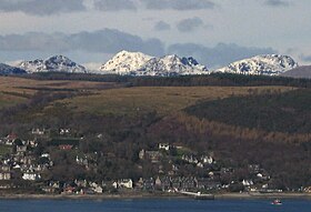
 View athort the Firth of Clyde, fae aboot 29 km (18 mi) sooth o Arrochar. Fae the left, The Brack, the snawy mass of Beinn Ìme, the peaks o the Cobbler and Beinn Narnain. See a wider view. | |
| Heichest pynt | |
| Peak | Beinn Ìme |
| Elevation | 1,011 m (3,317 ft) |
| Coordinates | 56°14′09″N 4°49′01″W / 56.23583°N 4.81694°WCoordinates: 56°14′09″N 4°49′01″W / 56.23583°N 4.81694°W |
| Geografie | |
| Kintra | Scotland |
| State/Province | Argyll and Bute |
References
eedit- ↑ Ordnance Survey: Landranger map sheet 56 Loch Lomond & Inveraray (Map). Ordnance Survey. 2012. ISBN 978-0-319-22981-1.