Arnhem
![]() Arnhem (Law-Saxon: Ernem) is a ceity in the aest o the Netherlands, an the caipital o the province Gelderland. It haes aboot 141 600 indwallers (2005), an is ane o the 15 lairgest ceities in the Netherlands.
Arnhem (Law-Saxon: Ernem) is a ceity in the aest o the Netherlands, an the caipital o the province Gelderland. It haes aboot 141 600 indwallers (2005), an is ane o the 15 lairgest ceities in the Netherlands.
Arnhem | |
|---|---|
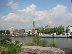
 Skyline o Arnhem | |
 Location in Gelderland | |
| Coordinates: 51°59′N 5°55′E / 51.983°N 5.917°ECoordinates: 51°59′N 5°55′E / 51.983°N 5.917°E | |
| Kintra | Netherlands |
| Province | Gelderland |
| Govrenment | |
| • Bodi | Municipal cooncil |
| • Mayor | Herman Kaiser (CDA) |
| Area | |
| • Municipality | 101.54 km2 (39.20 sq mi) |
| • Laund | 97.99 km2 (37.83 sq mi) |
| • Water | 3.55 km2 (1.37 sq mi) |
| Elevation | 13 m (43 ft) |
| Population | |
| • Municipality | 162,424 |
| • Density | 1658/km2 (4,290/sq mi) |
| • Urban | 152,850 |
| • Metro | 361,048 |
| Demonym(s) | Arnhemmer |
| Time zone | UTC+1 (CET) |
| • Summer (DST) | UTC+2 (CEST) |
| Postcode | 6800–6846 |
| Aurie code | 026 |
| Website | www |

Arnhem wis grantit ceity-richts in 1233 bi Otto II, coont o Guelders that wis Coont o Zutphen.

In 1850 Arnhem haed aboot 9 000 indwallers, but in the 19t hunneryear Arnhem becam popular wi upper-cless fowk frae the wastren pairt o the Netherlands.

Throu Warld-War II Arnhem wis skaithed sair. In the battle o Arnhem in September 1944 mony Breetish and Polish sodgers wis kilt. Efter the battle o Arnhem wis lost, 95 000 ceetizen were evacuatit, feckly tae the open air museum whaur they bidet in the 19. hunneryear ferms. Efter thay cam back, the ceity wis herried. Mony biggins wis malafousterd. In 1978 the brig ower the watter Rhine wis named efter John Frost, the Breetish heidsman.
Efter the war Arnhem wis upbuilt again. Arnhem is the hindermaist ceity wi a trolley bus.
Tourist Attractions
eedit- Burgers Zoo
- Nederlands openluchtmuseum - a open air museum wi 18t and 19t hunneryear ferms
- Eusebiuskerk - Lairgest kirk o Arnhem
- Park Sonsbeek
- John Frost Brig
- Bronbeek - museum aboot Dutch colonialism in the Dutch-Indies
References
eedit- ↑ "Herman Kaiser (burgemeester)" (in Dutch). Gemeente Arnhem. Archived frae the original on 19 October 2014. Retrieved 10 Juin 2014. Unknown parameter
|trans_title=ignored (help) - ↑ "Kerncijfers wijken en buurten" [Key figures for neighbourhoods]. CBS Statline (in Dutch). CBS. 2 Julie 2013. Retrieved 12 Mairch 2014.
- ↑ "Postcodetool for 6811DG". Actueel Hoogtebestand Nederland (in Dutch). Het Waterschapshuis. Archived frae the original on 21 September 2013. Retrieved 10 Juin 2014. Cite has empty unkent parameter:
|trans_title=(help) - ↑ "Bevolkingsontwikkeling; regio per maand" [Population growth; regions per month]. CBS Statline (in Dutch). CBS. 1 Januar 2021. Retrieved 2 Januar 2022.
- ↑ "Bevolkingsontwikkeling; regio per maand" [Population growth; regions per month]. CBS Statline (in Dutch). CBS. 26 Juin 2014. Retrieved 24 Julie 2014.
| Wikimedia Commons haes media relatit tae Arnhem. |

