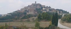
Argençola
Argençola (Catalan pronunciation: [ərʒənˈsɔɫə]) is a municipality in the comarca o the Anoia in Catalonie, Spain. It is situatit in the east o the comarca, borderin the Segarra an the Conca de Barberà. The Anoia river haes its source on the territory o the municipality. A local road links the municipality wi the main N-II road frae Barcelona tae Lleida.
Argençola | |
|---|---|
 | |
| Coordinates: 41°35′54″N 1°26′37″E / 41.59833°N 1.44361°ECoordinates: 41°35′54″N 1°26′37″E / 41.59833°N 1.44361°E | |
| Kintra | |
| Commonty | |
| Province | Barcelona |
| Comarca | Anoia |
| Govrenment | |
| • Mayor | Antoni Lloret Grau |
| Area | |
| • Total | 47.09 km2 (18.18 sq mi) |
| Elevation | 716 m (2,349 ft) |
| Population (2007) | |
| • Total | 229 |
| • Density | 4.9/km2 (13/sq mi) |
| Demonym(s) | Argençolenc, argençolenca |
| Time zone | UTC+1 (CET) |
| • Summer (DST) | UTC+2 (CEST) |
Demografie
eedit| 1900 | 1930 | 1950 | 1970 | 1986 | 2007 |
|---|---|---|---|---|---|
| 510 | 658 | 622 | 239 | 192 | 229 |
Subdiveesions
eeditThe municipality o Argençola includes sax ootlyin veelages. Populations are gien as o 2001:
- Carbasi (30), tae the north-east o Argençola at a elevation o 775 m
- Clariana (36), tae the east o Argençola, wi ruins o Clariana castle
- Contrast (18), tae the sooth-east o Argençola
- Els Plans de Ferran (7)
- Porquerisses i Aberells (41), tae the north o Argençola
- Rocamora (8), tae the wast o Argençola
References
eedit- Panareda Clopés, Josep Maria; Rios Calvet, Jaume; Rabella Vives, Josep Maria (1989). Guia de Catalunya, Barcelona:Caixa de Catalunya. ISBN 84-87135-01-3 (Spanish). ISBN 84-87135-02-1 (Catalan).
Freemit airtins
eedit- Offeecial wabsteid[deid airtin] (in Catalan)
- Information - Generalitat de Catalunya Archived 2007-03-10 at the Wayback Machine (in Catalan)
- Statistical information - Institut d'Estadística de Catalunya (in Catalan)

