File:Israel location map with stripes.svg

Size of this PNG preview of this SVG file: 322 × 598 pixels. Ither resolutions: 129 × 240 pixels | 258 × 480 pixels | 413 × 768 pixels | 551 × 1,024 pixels | 1,102 × 2,048 pixels | 614 × 1,141 pixels.
Oreeginal file (SVG file, nominallie 614 × 1,141 pixels, file size: 170 KB)
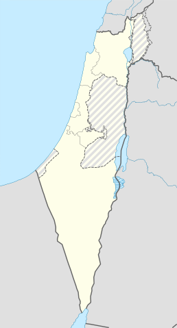
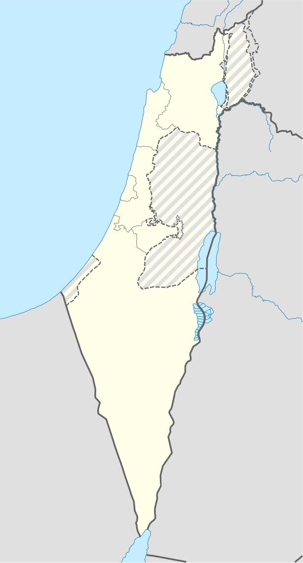
| Descreeption | Location map of Israel, with the Israeli-occupied Palestinian territories of the West Bank and the Gaza Strip and the Syrian Golan Heights grey stripes. | ||
| Date | |||
| Soorce | Own work based on: Israel location map.svg by NordNordWest | ||
| Author | Jackmcbarn | ||
| Permission (Reuisin this file) |
I, the copyright holder of this work, hereby publish it under the following licenses:
This file is licensed unner the Creative Commons Attribution-Share Alike 3.0 Unported license.
Ye mey select the license o yer choice. |
||
| SVG genesis | This locator map was created with unknown tool. |

File history
Clap oan ae date/time fer tae see the file aes it kithed at that time.
| Date/Time | Thummnail | Dimensions | Uiser | Comment | |
|---|---|---|---|---|---|
| current | 14:43, 16 Juin 2018 | | 614 × 1,141 (170 KB) | Jdx | Reverted to version as of 10:35, 16 June 2018 (UTC) |
| 14:04, 16 Juin 2018 |  | 504 × 936 (170 KB) | Beebbeebe | Reverted to version as of 00:40, 16 June 2018 (UTC) don't revert without stating a reason | |
| 10:35, 16 Juin 2018 |  | 614 × 1,141 (170 KB) | Denniss | Reverted to version as of 04:28, 21 May 2018 (UTC) | |
| 00:40, 16 Juin 2018 |  | 504 × 936 (170 KB) | Beebbeebe | Reverted to version as of 19:23, 14 May 2018 (UTC) The current map is simply incorrect. And I don't want to upload a new one, I'll have to edit more than a hundred wiki-articles. | |
| 04:28, 21 Mey 2018 |  | 614 × 1,141 (170 KB) | Nableezy | Reverted to version as of 19:08, 18 September 2016 (UTC) actually go back to standard no green or blue lines | |
| 18:23, 15 Mey 2018 |  | 614 × 1,141 (174 KB) | Nableezy | Reverted to version as of 03:49, 14 May 2018 (UTC) | |
| 19:23, 14 Mey 2018 |  | 504 × 936 (170 KB) | Eric's son | Reverted to version as of 13:42, 24 March 2018 (UTC) | |
| 03:49, 14 Mey 2018 |  | 614 × 1,141 (174 KB) | Nableezy | Reverted to version as of 06:09, 11 March 2018 (UTC) restore golan as occupied territory | |
| 13:42, 24 Mairch 2018 |  | 504 × 936 (170 KB) | Eric's son | Correcting color for border with Jordan | |
| 13:26, 24 Mairch 2018 |  | 504 × 936 (170 KB) | Eric's son | Fixed correct colors with vector |
Eimage airtins
Mair nor 100 pages airt til this file. The follaein leet shaws the first 100 page airtins that uise this file anely . Ae fu leet is available.
- Abu Snan
- Acre, Israel
- Afula
- Ar'ara
- Arad, Israel
- Ashdod
- Ashkelon
- Azor
- Baqa-Jatt
- Basma
- Basmat Tab'un
- Bat Yam
- Be'er Ya'akov
- Beersheba
- Beit Dagan
- Beit She'an
- Binyamina-Giv'at Ada
- Bir al-Maksur
- Bnei Brak
- Bu'eine Nujeidat
- Daliyat al-Karmel
- Dimona
- Eilat
- El'ad
- Fureidis
- Gedera
- Giv'at Shmuel
- Givatayim
- Hadera
- Haifa
- Herzliya
- Hod HaSharon
- Holon
- Ilut
- Isfiya
- Jerusalem
- Jisr az-Zarqa
- Ka'abiyye-Tabbash-Hajajre
- Kafr Qara
- Kafr Qasim
- Karmiel
- Katzir-Harish
- Kaukab Abu al-Hija
- Kfar Kama
- Kfar Saba
- Kfar Shmaryahu
- Kfar Tavor
- Kiryat Ata
- Kiryat Bialik
- Kiryat Malakhi
- Kiryat Motzkin
- Kiryat Ono
- Kiryat Shmona
- Kiryat Tiv'on
- Kiryat Yam
- Lod
- Ma'ale Iron
- Ma'alot-Tarshiha
- Majd al-Krum
- Masada
- Mashhad, Israel
- Migdal HaEmek
- Modi'in-Maccabim-Re'ut
- Nahariya
- Nazareth
- Nazareth Illit
- Nesher
- Ness Ziona
- Netanya
- Or Akiva
- Or Yehuda
- Petah Tikva
- Ra'anana
- Rahat
- Ramat Gan
- Ramat HaSharon
- Rameh
- Ramla
- Rehovot
- Rekhasim
- Rishon LeZion
- Rosh HaAyin
- Safed
- Sakhnin
- Shaghur
- Shefa-'Amr
- Tamra
- Tayibe
- Tel Aviv
- Tiberias
- Tira, Israel
- Tirat Carmel
- Tur'an
- Umm al-Fahm
- Yavne
- Yehud-Monosson
- Yesud HaMa'ala
- Yirka
- Yokneam
- Zarzir
See mair links til this file.
Global file uisage
The follaein ither wikis uise this file:
- Uisage on af.wikipedia.org
- Rehovot
- Nasaret
- Eilat
- Dimona
- Ramla
- Safed
- Tiberias
- Lod
- Ben Gurion Internasionale Lughawe
- Hadera
- Gedera
- Givatayim
- Be'er Sheva
- Rishon LeZion
- Petah Tikva
- Ashdod
- Netanya
- Binyamina-Giv'at Ada
- Bnei Brak
- Holon
- Ramat Gan
- Ashkelon
- Bat Yam
- Beit Shemesh
- Kfar Saba
- Herzliya
- Modi'in-Maccabim-Re'ut
- Ra'anana
- Ramon-lughawe
- Uisage on an.wikipedia.org
- Uisage on ar.wikipedia.org
- القوات الجوية الإسرائيلية
- قلعة كوكب الهوا
- قالب:Location map Israel Golan
- قالب:Location map Israel ashkelon
- قالب:Location map Israel binyamin
- قالب:Location map Israel center ta
- قالب:Location map Israel haifa
- قالب:Location map Israel jezreel
- قالب:Location map Israel negev mt
- قالب:Location map Israel north haifa
- قالب:Location map Israel north negev
- قالب:Location map Israel northeast
- قالب:Location map Israel northwest
- قالب:Location map Israel northwest negev
- قالب:Location map Israel shomron
- قالب:Location map Israel south wb
- ثقافة كبارية
- مغارة كبارة
View mair global usage o this file.