File:Verlaufskarte Inn DE.png
Size o this luikower: 674 × 599 pixels. Ither resolutions: 270 × 240 pixels | 540 × 480 pixels | 864 × 768 pixels | 1,152 × 1,024 pixels | 2,117 × 1,882 pixels.
Oreeginal file (2,117 × 1,882 pixels, file size: 5.54 MB, MIME type: image/png)
Ootline
| Descreeption |
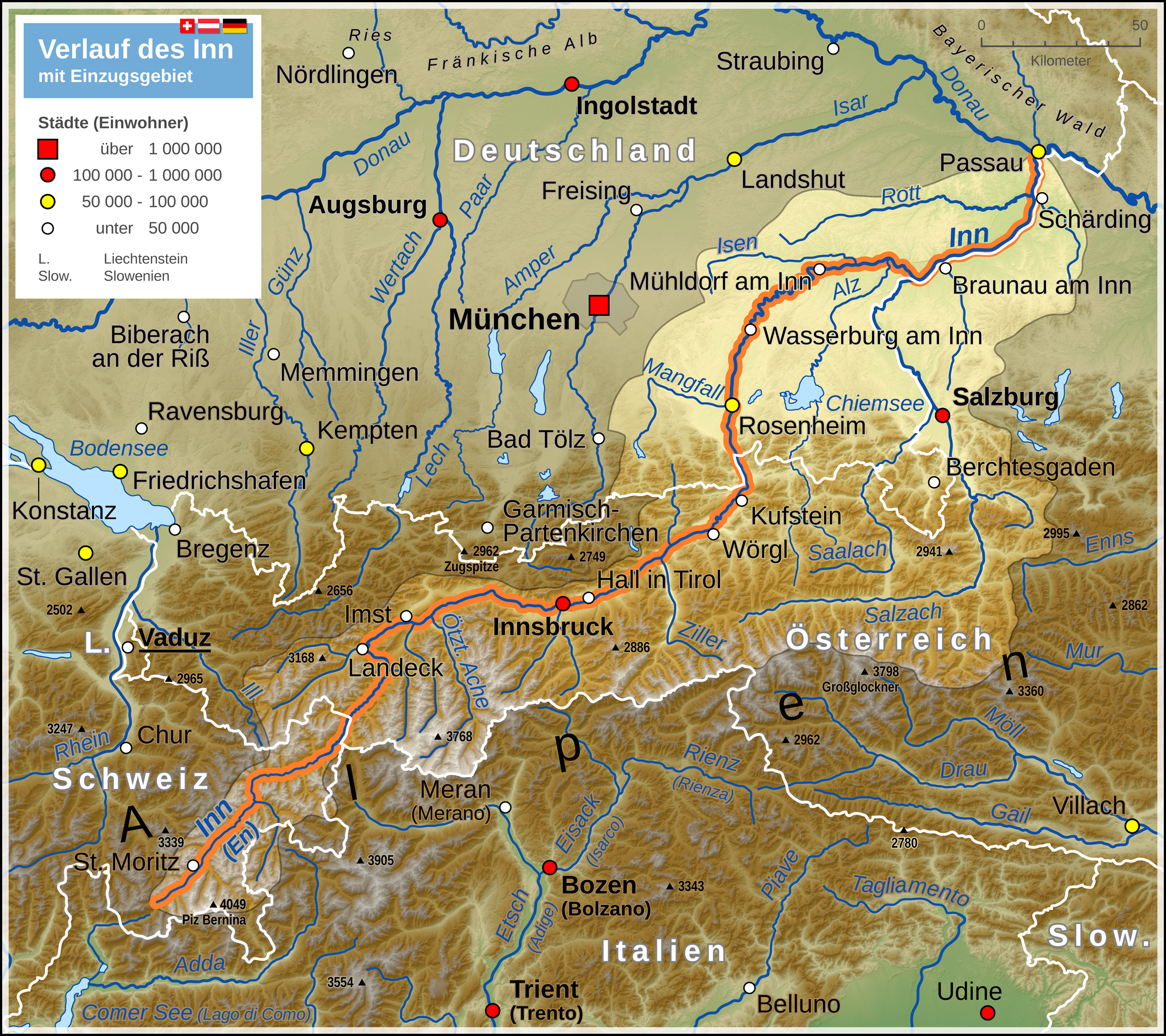
Deutsch: Verlaufskarte des Inn mit Darstellung des Einzugsgebietes
English: Map of Inn river (including drainage basin) |
| Date | |
| Soorce |
Ain wirk Map created using: |
| Author | Thoroe |
| Permission (Reuisin this file) |
Map data (c) OpenStreetMap (and) contributors, CC-BY-SA |

|
This map has been made or improved in the German Kartenwerkstatt (Map Lab). You can propose maps to improve as well.
|
Licensin
This file is licensed under the Creative Commons Attribution-Share Alike 2.0 Generic license.
Attribution: Thomas Römer/OpenStreetMap data
- Ye are free:
- tae share – tae copy, distribute an transmit the wirk
- tae remix – tae adapt the wirk
- Unner the follaein condeetions:
- attribution – Ye must attribute the wirk in the manner specified bi the author or licensor (but nae in ony way that suggests that thay endorse ye or yer uise o the wirk).
- share alik – If ye alter, transform, or big upon this wirk, ye mey distribute the resultin wirk anly unner the same or seemilar license tae this ane.
File history
Clap oan ae date/time fer tae see the file aes it kithed at that time.
| Date/Time | Thummnail | Dimensions | Uiser | Comment | |
|---|---|---|---|---|---|
| current | 14:41, 6 Julie 2014 | | 2,117 × 1,882 (5.54 MB) | Thoroe | ein paar mehr Flüsse |
| 15:06, 3 Mey 2013 |  | 2,117 × 1,882 (5.52 MB) | Thoroe | Einzugsgebiet korrigiert +einige Gewässer | |
| 21:24, 3 August 2012 |  | 1,059 × 941 (2 MB) | Kontrollstellekundl | Das Standesamt Udine bestätigte für den 31. Januar 2012 erstmals seit 25 Jahren wieder mehr als 100.000 Einwohner - von Gelb auf Rot.<ref>http://messaggeroveneto.gelocal.it/cronaca/2012/02/03/news/udine-torna-sopra-i-100-mila-abitanti-1.3140196</... | |
| 14:48, 18 October 2011 |  | 1,059 × 941 (1.88 MB) | Thoroe | farbliche Überarbeitung, Details am Einzugsgebiet | |
| 18:31, 9 October 2011 |  | 1,059 × 941 (1.84 MB) | Thoroe | Einzugsgebiet, Legende reduziert, Geländehöhen, noch ein paar Nebenflüsse etc. | |
| 10:44, 6 October 2011 |  | 1,059 × 941 (1.8 MB) | Thoroe | mehr Orte und diverse Änderungen | |
| 14:19, 1 October 2011 |  | 1,059 × 941 (1.78 MB) | Thoroe | {{Information |Description ={{de|1=Verlauf des Inn}} |Source ={{own}} Map created using: *[http://gmt.soest.hawaii.edu Generic Mapping Tools (GMT)] with SRTM3 V2 data *[http://www.openstreetmap.org OpenStreetMap] data *[[:File:Flag |
Eimage airtins
The follaein pages airts tae this image:
Global file uisage
The follaein ither wikis uise this file:
- Uisage on af.wikipedia.org
- Uisage on als.wikipedia.org
- Uisage on an.wikipedia.org
- Uisage on bg.wikipedia.org
- Uisage on bs.wikipedia.org
- Uisage on cs.wikipedia.org
- Uisage on da.wikipedia.org
- Uisage on de.wikipedia.org
- Uisage on el.wikipedia.org
- Uisage on en.wikipedia.org
- Uisage on eo.wikipedia.org
- Uisage on es.wikipedia.org
- Uisage on frr.wikipedia.org
- Uisage on fr.wikipedia.org
- Uisage on he.wikipedia.org
- Uisage on hr.wikipedia.org
- Uisage on hu.wikipedia.org
- Uisage on hy.wikipedia.org
- Uisage on incubator.wikimedia.org
- Uisage on it.wikipedia.org
- Uisage on ja.wikipedia.org
- Uisage on ka.wikipedia.org
- Uisage on ko.wikipedia.org
- Uisage on lld.wikipedia.org
- Uisage on mk.wikipedia.org
- Uisage on ml.wikipedia.org
- Uisage on nl.wikipedia.org
- Uisage on nn.wikipedia.org
- Uisage on no.wikipedia.org
- Uisage on pl.wikipedia.org
- Uisage on pl.wiktionary.org
- Uisage on pnb.wikipedia.org
- Uisage on rm.wikipedia.org
- Uisage on ru.wikipedia.org
- Uisage on sh.wikipedia.org
- Uisage on sl.wikipedia.org
- Uisage on sr.wikipedia.org
- Uisage on sv.wikipedia.org
View mair global usage o this file.