File:Toyonaka in Osaka Prefecture Ja.svg

Oreeginal file (SVG file, nominallie 490 × 690 pixels, file size: 31 KB)
Ootline
| Descreeption |
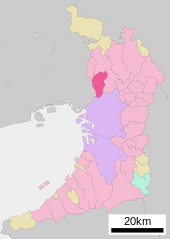
English: Location of Toyonaka in Osaka Prefecture
|
||
| Date | (UTC) | ||
| Soorce |
|
||
| Author | Lincun | ||
| Permission (Reuisin this file) |
|
Licensin

|
Permission is grantit tae copy, distribute an/or modify this document unner the terms o the GNU Free Documentation License, Version 1.2 or ony later version published bi the Free Software Foundation; wi no Invariant Sections, no Front-Cover Texts, an no Back-Cover Texts. A copy o the license is includit in the section enteetled GNU Free Documentation License. |
- Ye are free:
- tae share – tae copy, distribute an transmit the wirk
- tae remix – tae adapt the wirk
- Unner the follaein condeetions:
- attribution – Ye must attribute the wirk in the manner specified bi the author or licensor (but nae in ony way that suggests that thay endorse ye or yer uise o the wirk).
- share alik – If ye alter, transform, or big upon this wirk, ye mey distribute the resultin wirk anly unner the same or seemilar license tae this ane.
Original upload log
| This file was moved from Japanese Wikipedia.
See below for original file information. | ||||||||||||||||||||||||
| ||||||||||||||||||||||||
|
| ||||||||||||||||||||||||
File history
Clap oan ae date/time fer tae see the file aes it kithed at that time.
| Date/Time | Thummnail | Dimensions | Uiser | Comment | |
|---|---|---|---|---|---|
| current | 11:50, 15 December 2020 | | 490 × 690 (31 KB) | AichiWikiFixer | Changed. |
| 11:47, 15 December 2020 |  | 500 × 772 (16 KB) | AichiWikiFixer | Incorrect location | |
| 08:40, 22 October 2020 |  | 490 × 690 (30 KB) | AichiWikiFixer | Updated as File:Map_of_Osaka_Prefecture_Ja.svg | |
| 08:29, 10 October 2009 |  | 500 × 772 (16 KB) | Monaneko | {{Information |Description={{en|1=Location of Toyonaka in Osaka Prefecture}} {{ja|1=大阪府豊中市の位置}} |Source=ja:File:基礎自治体位置図 27203.svg |Author=ja:User:Lincun |Date=2007-10-05 13:37 (UTC) |Permission= |other_versions | |
| 13:37, 5 October 2007 |  | 500 × 772 (16 KB) | Lincun | {{基礎自治体位置図画像情報|大阪府|豊中市}} |
Eimage airtins
The follaein pages airts tae this image:
Global file uisage
The follaein ither wikis uise this file:
- Uisage on ar.wikipedia.org
- Uisage on arz.wikipedia.org
- Uisage on ca.wikipedia.org
- Uisage on ceb.wikipedia.org
- Uisage on ce.wikipedia.org
- Uisage on en.wikipedia.org
- Uisage on eo.wikipedia.org
- Uisage on es.wikipedia.org
- Uisage on eu.wikipedia.org
- Uisage on fa.wikipedia.org
- Uisage on fi.wikipedia.org
- Uisage on fr.wikipedia.org
- Uisage on ga.wikipedia.org
- Uisage on gl.wikipedia.org
- Uisage on ja.wikipedia.org
- Uisage on ko.wikipedia.org
- Uisage on ms.wikipedia.org
- Uisage on mzn.wikipedia.org
- Uisage on nl.wikipedia.org
- Uisage on ro.wikipedia.org
- Uisage on sh.wikipedia.org
- Uisage on simple.wikipedia.org
- Uisage on sr.wikipedia.org
- Uisage on sv.wikipedia.org
- Uisage on tg.wikipedia.org
- Uisage on th.wikipedia.org
- Uisage on tt.wikipedia.org
- Uisage on uk.wikipedia.org
- Uisage on ur.wikipedia.org
- Uisage on vi.wikipedia.org
- Uisage on www.wikidata.org
- Uisage on zh-min-nan.wikipedia.org
- Uisage on zh.wikipedia.org