File:Topographic map of Saint Helena-en.svg

Size of this PNG preview of this SVG file: 740 × 600 pixels. Ither resolutions: 296 × 240 pixels | 592 × 480 pixels | 948 × 768 pixels | 1,264 × 1,024 pixels | 2,527 × 2,048 pixels | 802 × 650 pixels.
Oreeginal file (SVG file, nominallie 802 × 650 pixels, file size: 583 KB)
Ootline
| Descreeption |
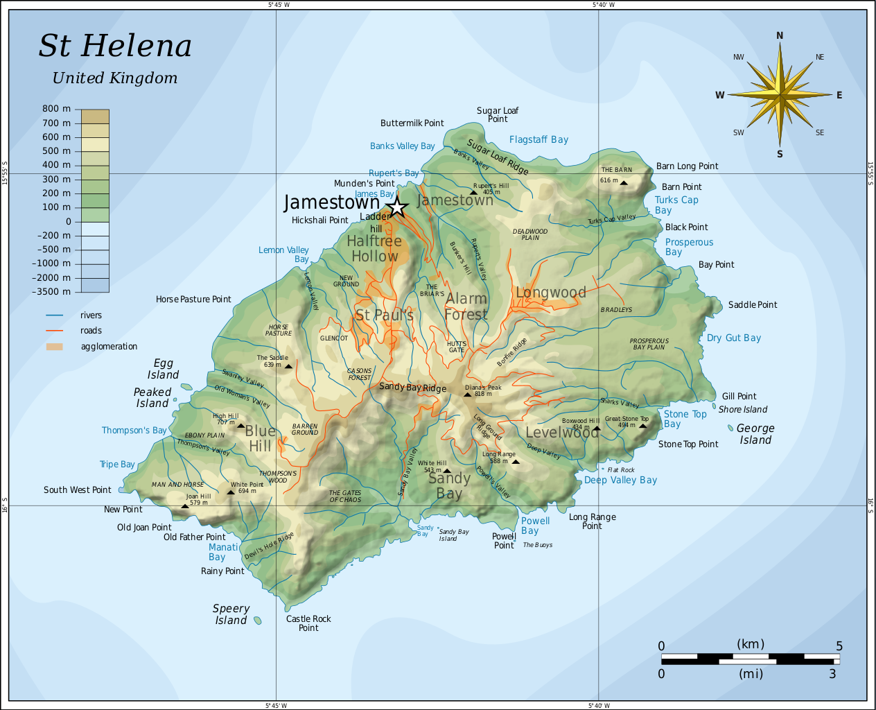
English: Topographic map of the British island of Saint Helena. |
| Date | |
| Soorce |
Self-made in Inkscape. Based on several sources:
|
| Author | Oona Räisänen (Mysid) |
| Other versions |
Derivative works of this file: |

|
This SVG file contains embedded text that can be translated into your language, using any capable SVG editor, text editor or the SVG Translate tool. For more information see: About translating SVG files. |
Licensin
I, the copyright holder of this work, hereby publish it under the following licenses:
This file is licensed unner the Creative Commons Attribution-Share Alike 3.0 Unported license.
- Ye are free:
- tae share – tae copy, distribute an transmit the wirk
- tae remix – tae adapt the wirk
- Unner the follaein condeetions:
- attribution – Ye must attribute the wirk in the manner specified bi the author or licensor (but nae in ony way that suggests that thay endorse ye or yer uise o the wirk).
- share alik – If ye alter, transform, or big upon this wirk, ye mey distribute the resultin wirk anly unner the same or seemilar license tae this ane.

|
Permission is grantit tae copy, distribute an/or modify this document unner the terms o the GNU Free Documentation License, Version 1.2 or ony later version published bi the Free Software Foundation; wi no Invariant Sections, no Front-Cover Texts, an no Back-Cover Texts. A copy o the license is includit in the section enteetled GNU Free Documentation License. |
Ye mey select the license o yer choice.
File history
Clap oan ae date/time fer tae see the file aes it kithed at that time.
| Date/Time | Thummnail | Dimensions | Uiser | Comment | |
|---|---|---|---|---|---|
| current | 05:54, 10 August 2010 | | 802 × 650 (583 KB) | Mysid | legend for roads, rivers, agglomeration |
| 21:42, 9 August 2010 |  | 802 × 650 (580 KB) | Mysid | bugfix #2 | |
| 21:40, 9 August 2010 |  | 802 × 650 (260 KB) | Mysid | bugfix | |
| 21:27, 9 August 2010 |  | 647 × 594 (579 KB) | Mysid | {{Information |Description={{en|1=Topographic map of the British island of w:Saint Helena.}} |Source=Self-made in Inkscape. Based on several sources. |Author=Mysid |Date=2010-08-10 |Permission= |other_versions= }} {{translation possi |
Eimage airtins
The follaein pages airts tae this image:
Global file uisage
The follaein ither wikis uise this file:
- Uisage on af.wikipedia.org
- Uisage on als.wikipedia.org
- Uisage on ar.wikipedia.org
- Uisage on arz.wikipedia.org
- Uisage on ast.wikipedia.org
- Uisage on bg.wikipedia.org
- Uisage on bn.wikipedia.org
- Uisage on bs.wikipedia.org
- Uisage on ca.wikipedia.org
- Uisage on ckb.wikipedia.org
- Uisage on da.wikipedia.org
- Uisage on el.wikipedia.org
- Uisage on en.wikipedia.org
- Uisage on eo.wikipedia.org
- Uisage on es.wikipedia.org
- Uisage on eu.wikipedia.org
- Uisage on fa.wikipedia.org
- Uisage on fi.wikipedia.org
- Uisage on fy.wikipedia.org
- Uisage on ga.wikipedia.org
- Uisage on gl.wikipedia.org
- Uisage on gv.wikipedia.org
- Uisage on he.wikipedia.org
- Uisage on hr.wikipedia.org
- Uisage on hu.wikipedia.org
- Uisage on hy.wikipedia.org
- Uisage on ie.wikipedia.org
- Uisage on io.wikipedia.org
- Uisage on it.wikipedia.org
View mair global usage o this file.