File:Tembin 2017-12-24 0550Z.jpg

Size o this luikower: 450 × 600 pixels. Ither resolutions: 180 × 240 pixels | 360 × 480 pixels | 576 × 768 pixels | 768 × 1,024 pixels | 1,536 × 2,048 pixels | 5,010 × 6,680 pixels.
Oreeginal file (5,010 × 6,680 pixels, file size: 7.91 MB, MIME type: image/jpeg)
Ootline
|
| Descreeption |
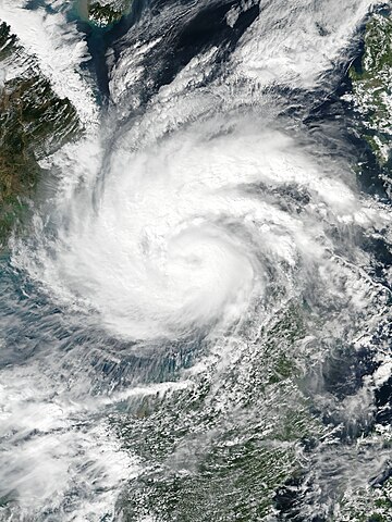
English: Typhoon Tembin at peak intensity over the South China Sea on December 24, 2017. |
| Date | |
| Soorce | EOSDIS Worldview |
| Author | VIIRS image captured by NOAA’s Suomi NPP satellite |
| Camera location | | View this and other nearby images on: OpenStreetMap |
|---|
Licensin
| This file is in the public domain in the United States because it was solely created by NASA. NASA copyright policy states that "NASA material is not protected by copyright unless noted". (See Template:PD-USGov, NASA copyright policy page or JPL Image Use Policy.) | ||
 |
Warnings:
|
File history
Clap oan ae date/time fer tae see the file aes it kithed at that time.
| Date/Time | Thummnail | Dimensions | Uiser | Comment | |
|---|---|---|---|---|---|
| current | 13:45, 24 December 2017 | | 5,010 × 6,680 (7.91 MB) | Meow | User created page with UploadWizard |
Eimage airtins
The'r nae pages airts tae this eimage.
Global file uisage
The follaein ither wikis uise this file:
- Uisage on cs.wikipedia.org
- Uisage on de.wikipedia.org
- Uisage on en.wikipedia.org
- Uisage on id.wikipedia.org
- Uisage on ja.wikipedia.org
- Uisage on ko.wikipedia.org
- Uisage on ms.wikipedia.org
- Uisage on my.wikipedia.org
- Uisage on pt.wikipedia.org
- Uisage on ru.wikipedia.org
- Uisage on th.wikipedia.org
- Uisage on tl.wikipedia.org
- Uisage on vi.wikipedia.org
- Uisage on zh-yue.wikipedia.org
- Uisage on zh.wikipedia.org