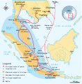
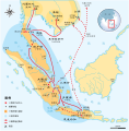
File:Srivijaya Empire.svg

Size of this PNG preview of this SVG file: 468 × 476 pixels. Ither resolutions: 236 × 240 pixels | 472 × 480 pixels | 755 × 768 pixels | 1,007 × 1,024 pixels | 2,014 × 2,048 pixels.
Oreeginal file (SVG file, nominallie 468 × 476 pixels, file size: 336 KB)
File history
Clap oan ae date/time fer tae see the file aes it kithed at that time.
| Date/Time | Thummnail | Dimensions | Uiser | Comment | |
|---|---|---|---|---|---|
| current | 22:41, 3 December 2014 |  | 468 × 476 (336 KB) | Pratyeka | Reposition 'Malacca Straight' label for improved clarity. |
| 22:33, 3 December 2014 |  | 468 × 476 (336 KB) | Pratyeka | Addition of Lamuri, an important point in northwestern Sumatra identified as contemporary and whose location at Lhok Lambaro is reasoned by E. Edwards McKinnon in ''[http://www.scribd.com/doc/8410125/A-note-of-Lamuri-Lambri-Sumatra-Straits-of-Melaka-Ma... | |
| 19:15, 26 August 2009 |  | 468 × 476 (288 KB) | Gunkarta | {{Information |Description={{en|1=Maximum extent of Srivijaya Empire around 8th century. Expanding from Sumatra, Central Java, to Malay Peninsula. The red arrows show the series of Srivijayan expedition and conquest, in diplomatic alliances, military camp |
Eimage airtins
The'r nae pages airts tae this eimage.
Global file uisage
The follaein ither wikis uise this file:
- Uisage on azb.wikipedia.org
- Uisage on ba.wikipedia.org
- Uisage on be.wikipedia.org
- Uisage on bg.wikipedia.org
- Uisage on bn.wikipedia.org
- Uisage on ca.wikipedia.org
- Uisage on cs.wikipedia.org
- Uisage on da.wikipedia.org
- Uisage on en.wikipedia.org
- Uisage on eo.wikipedia.org
- Uisage on fa.wikipedia.org
- Uisage on fi.wikibooks.org
- Uisage on ha.wikipedia.org
- Uisage on hi.wikipedia.org
- Uisage on hu.wikipedia.org
- Uisage on hy.wikipedia.org
- Uisage on id.wikipedia.org
- Uisage on io.wikipedia.org
- Uisage on it.wikipedia.org
- Uisage on ja.wikipedia.org
- Uisage on ja.wikibooks.org
- Uisage on ka.wikipedia.org
- Uisage on km.wikipedia.org
- Uisage on ko.wikipedia.org
- Uisage on lt.wikipedia.org
- Uisage on lv.wikipedia.org
- Uisage on min.wikipedia.org
- Uisage on ml.wikipedia.org
- Uisage on mr.wikipedia.org
View mair global usage o this file.


