File:River Nith estuary.jpg

Size o this luikower: 800 × 533 pixels. Ither resolutions: 320 × 213 pixels | 640 × 427 pixels | 1,024 × 683 pixels | 1,280 × 853 pixels | 2,560 × 1,707 pixels | 3,504 × 2,336 pixels.
Oreeginal file (3,504 × 2,336 pixels, file size: 8.68 MB, MIME type: image/jpeg)
Ootline
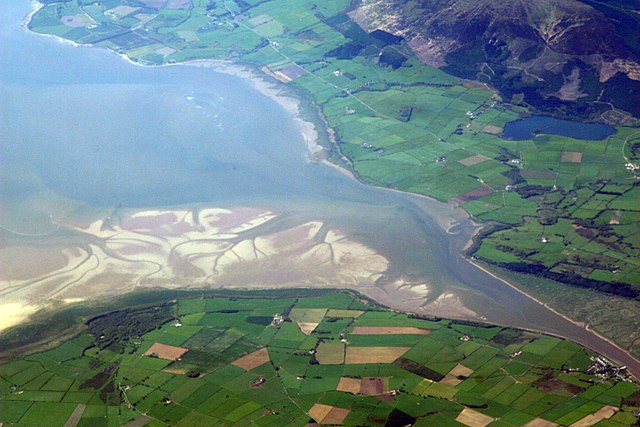
| Descreeption | The estuary of the River Nith, Scotland, at low tide; opening into Solway Firth. This is a view of the Nith estuary from the north-east. The group of buildings at bottom right is the village of Glencaple. At bottom left near the wooded area is Caerlaverock Castle. At top right is Loch Kindar and the hill above is called Criffel. Just beyond the top left of photo is the birthplace of John Paul Jones. |
| Date | |
| Soorce | https://www.flickr.com/photos/52614599@N00/483602946 |
| Author | Doc Searls from Santa Barbara, USA |
Licensin
This file is licensed under the Creative Commons Attribution-Share Alike 2.0 Generic license.
- Ye are free:
- tae share – tae copy, distribute an transmit the wirk
- tae remix – tae adapt the wirk
- Unner the follaein condeetions:
- attribution – Ye must attribute the wirk in the manner specified bi the author or licensor (but nae in ony way that suggests that thay endorse ye or yer uise o the wirk).
- share alik – If ye alter, transform, or big upon this wirk, ye mey distribute the resultin wirk anly unner the same or seemilar license tae this ane.
| This image was originally posted to Flickr by dsearls at https://www.flickr.com/photos/52614599@N00/483602946. It was reviewed on 5 Mey 2007 by FlickreviewR and was confirmed to be licensed under the terms of the cc-by-sa-2.0. |
This is a view of the Nith estuary from the north-east. The group of buildings at bottom right is the village of Glencaple. At bottom left near the wooded area is Caerlaverock Castle. At top right is Loch Kindar and the hill above is called Criffel. Just beyond the top left of photo is the birthplace of John Paul Jones.
File history
Clap oan ae date/time fer tae see the file aes it kithed at that time.
| Date/Time | Thummnail | Dimensions | Uiser | Comment | |
|---|---|---|---|---|---|
| current | 07:14, 5 Mey 2007 | | 3,504 × 2,336 (8.68 MB) | Sandstein | {{Information |Description= The estuary of the River Nith, Scotland, at low tide; opening into Solway Firth. On the near shore, Bowness-on-Solway. On the far, Annan, in Dumfries and Galloway. |Source= http://www.flickr.com/photos/52614599@N00/483602946 |D |
Eimage airtins
The follaein pages airts tae this image:
Global file uisage
The follaein ither wikis uise this file:
- Uisage on ar.wikipedia.org
- Uisage on arz.wikipedia.org
- Uisage on ast.wikipedia.org
- Uisage on bn.wikipedia.org
- Uisage on br.wikipedia.org
- Uisage on ceb.wikipedia.org
- Uisage on cs.wikipedia.org
- Uisage on cy.wikipedia.org
- Uisage on dag.wikipedia.org
- Uisage on de.wikipedia.org
- Uisage on en.wikipedia.org
- Uisage on en.wikivoyage.org
- Uisage on eo.wikipedia.org
- Uisage on es.wikipedia.org
- Uisage on eu.wikipedia.org
- Uisage on fa.wikipedia.org
- Uisage on fr.wikipedia.org
- Uisage on fy.wikipedia.org
- Uisage on ga.wikipedia.org
- Uisage on gd.wikipedia.org
- Uisage on gv.wikipedia.org
- Uisage on hak.wikipedia.org
- Uisage on id.wikipedia.org
- Uisage on incubator.wikimedia.org
- Uisage on it.wikipedia.org
- Uisage on it.wikibooks.org
- Uisage on it.wikiversity.org
- Uisage on ja.wikipedia.org
- Uisage on kbd.wikipedia.org
- Uisage on lt.wikipedia.org
- Uisage on nl.wikipedia.org
View mair global usage o this file.