File:Red Sea topographic map-en.jpg

Size o this luikower: 367 × 600 pixels. Ither resolutions: 147 × 240 pixels | 293 × 480 pixels | 470 × 768 pixels | 626 × 1,024 pixels | 1,655 × 2,705 pixels.
Oreeginal file (1,655 × 2,705 pixels, file size: 1.63 MB, MIME type: image/jpeg)
Ootline
| Camera location | | View this and other nearby images on: OpenStreetMap |
|---|
| Descreeption |
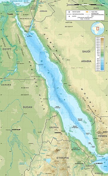
English: Topographic map in English of the Red Sea, UTM projection (WGS84 datum).
Note : for translation purpose, use the SVG version. Français : Carte topographique en anglais de la Mer Rouge, projection UTM (WGS84 datum).
|
||
| Date | |||
| Soorce | Own work (see complete description on Image:Red_Sea_topographic_map-en.svg) | ||
| Author | Eric Gaba (Sting - fr:Sting) | ||
| Permission (Reuisin this file) |
|
||
| Other versions |
[]
|


Licensin
I, the copyright holder of this work, hereby publish it under the following licenses:

|
Permission is grantit tae copy, distribute an/or modify this document unner the terms o the GNU Free Documentation License, Version 1.2 or ony later version published bi the Free Software Foundation; wi no Invariant Sections, no Front-Cover Texts, an no Back-Cover Texts. A copy o the license is includit in the section enteetled GNU Free Documentation License. |
This file is licensed under the Creative Commons Attribution-Share Alike 4.0 International, 3.0 Unported, 2.5 Generic, 2.0 Generic and 1.0 Generic license.
- Ye are free:
- tae share – tae copy, distribute an transmit the wirk
- tae remix – tae adapt the wirk
- Unner the follaein condeetions:
- attribution – Ye must attribute the wirk in the manner specified bi the author or licensor (but nae in ony way that suggests that thay endorse ye or yer uise o the wirk).
- share alik – If ye alter, transform, or big upon this wirk, ye mey distribute the resultin wirk anly unner the same or seemilar license tae this ane.
Ye mey select the license o yer choice.
File history
Clap oan ae date/time fer tae see the file aes it kithed at that time.
| Date/Time | Thummnail | Dimensions | Uiser | Comment | |
|---|---|---|---|---|---|
| current | 15:40, 29 December 2023 | | 1,655 × 2,705 (1.63 MB) | Sting | Without frame |
| 13:37, 19 Julie 2010 |  | 1,655 × 2,705 (1.68 MB) | Sting | Color profile | |
| 04:47, 2 September 2008 |  | 1,655 × 2,705 (1.6 MB) | Sting | New standard colors ; bathymetry from ETOPO1 ; etc. | |
| 19:35, 3 Apryle 2008 |  | 1,655 × 2,705 (1.67 MB) | Sting | Additional corrections | |
| 13:09, 3 Apryle 2008 |  | 1,655 × 2,705 (1.71 MB) | Sting | Some names corrections ; some improvements | |
| 11:26, 3 Apryle 2008 |  | 1,655 × 2,705 (1.67 MB) | Sting | Little correction | |
| 22:32, 2 Apryle 2008 |  | 1,655 × 2,705 (1.7 MB) | Sting | {{Location|21|00|00|N|38|00|00|E|scale:10000000}} <br/> {{Information |Description={{en|Topographic map in English of the red Sea<br/>''Note :'' for translation purpose, use the SVG version.}} {{fr |
Eimage airtins
The'r nae pages airts tae this eimage.
Global file uisage
The follaein ither wikis uise this file:
- Uisage on ami.wikipedia.org
- Uisage on am.wikipedia.org
- Uisage on ban.wikipedia.org
- Uisage on bg.wikipedia.org
- Uisage on bh.wikipedia.org
- Uisage on bn.wikipedia.org
- Uisage on ca.wikipedia.org
- Uisage on ckb.wikipedia.org
- Uisage on en.wikipedia.org
- Uisage on eu.wikipedia.org
- Uisage on fa.wikipedia.org
- Uisage on fa.wikivoyage.org
- Uisage on gu.wikipedia.org
- Uisage on hak.wikipedia.org
- Uisage on he.wikipedia.org
- Uisage on he.wiktionary.org
- Uisage on hi.wikipedia.org
- Uisage on hr.wikipedia.org
- Uisage on ilo.wikipedia.org
- Uisage on incubator.wikimedia.org
- Uisage on ja.wikipedia.org
- Uisage on ja.wikibooks.org
- Uisage on ka.wikipedia.org
- Uisage on kcg.wikipedia.org
- Uisage on kn.wikipedia.org
- Uisage on ko.wikipedia.org
- Uisage on lfn.wikipedia.org
- Uisage on lv.wikipedia.org
- Uisage on mai.wikipedia.org
- Uisage on ml.wikipedia.org
- Uisage on ms.wikipedia.org
- Uisage on my.wikipedia.org
- Uisage on ne.wikipedia.org
- Uisage on no.wikipedia.org
- Uisage on olo.wikipedia.org
View mair global usage o this file.