File:PapalStates1700.png
Nae heier resolution available.
PapalStates1700.png (375 × 228 pixels, file size: 6 KB, MIME type: image/png)
Ootline
| Descreeption |
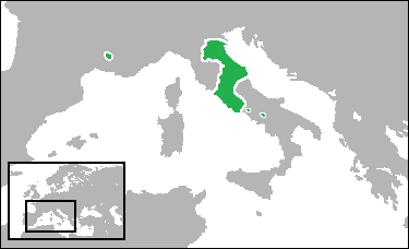
English: Locator map showing the Papal States, with its enclaves, in the year 1700. (Partially based on Euratlas map of Europe - 1700.) |
| Date | |
| Soorce | Ain wirk |
| Author | Gabagool |
Licensin
I, the copyright holder of this work, hereby publish it under the following license:
This file is licensed under the Creative Commons Attribution 3.0 Unported license.
- Ye are free:
- tae share – tae copy, distribute an transmit the wirk
- tae remix – tae adapt the wirk
- Unner the follaein condeetions:
- attribution – Ye must attribute the wirk in the manner specified bi the author or licensor (but nae in ony way that suggests that thay endorse ye or yer uise o the wirk).
File history
Clap oan ae date/time fer tae see the file aes it kithed at that time.
| Date/Time | Thummnail | Dimensions | Uiser | Comment | |
|---|---|---|---|---|---|
| current | 18:53, 7 Julie 2009 | | 375 × 228 (6 KB) | Gabagool | border |
| 19:57, 29 Juin 2009 |  | 375 × 228 (7 KB) | Gabagool | added papal enclaves in naples and france | |
| 17:29, 26 Juin 2009 |  | 375 × 228 (6 KB) | Gabagool | {{Information |Description={{en|1=Locator map showing the Duchy of Savoy in the year 1700. <br>(Partially based on Euratlas map of Europe - 1700.)}} |Source=Own work by uploader |Author=Gabagool / Jarle Grøhn |Date=2009-06-26 |Permissio |
Eimage airtins
The'r nae pages airts tae this eimage.
Global file uisage
The follaein ither wikis uise this file:
- Uisage on ar.wikipedia.org
- Uisage on ca.wikipedia.org
- Uisage on cs.wikipedia.org
- Uisage on cy.wikipedia.org
- Uisage on da.wikipedia.org
- Uisage on en.wikipedia.org
- Uisage on eo.wikipedia.org
- Uisage on et.wikipedia.org
- Uisage on eu.wikipedia.org
- Uisage on fa.wikipedia.org
- Uisage on ga.wikipedia.org
- Uisage on hr.wikipedia.org
- Uisage on hu.wikipedia.org
- Uisage on id.wikipedia.org
- Uisage on ilo.wikipedia.org
- Uisage on io.wikipedia.org
- Uisage on li.wikipedia.org
- Uisage on lv.wikipedia.org
- Uisage on ms.wikipedia.org
- Uisage on no.wikipedia.org
- Uisage on oc.wikipedia.org
- Uisage on pnb.wikipedia.org
- Uisage on ro.wikipedia.org
- Uisage on ru.wikipedia.org
- Uisage on sh.wikipedia.org
- Uisage on simple.wikipedia.org
- Uisage on sk.wikipedia.org
- Uisage on sr.wikipedia.org
- Uisage on sv.wikipedia.org
- Uisage on sw.wikipedia.org
- Uisage on ta.wikipedia.org
- Uisage on tl.wikipedia.org
- Uisage on vi.wikipedia.org
- Uisage on zh-yue.wikipedia.org
- Uisage on zh.wikipedia.org