File:Nile watershed topo.png
Size o this luikower: 285 × 599 pixels. Ither resolutions: 114 × 240 pixels | 554 × 1,164 pixels.
Oreeginal file (554 × 1,164 pixels, file size: 560 KB, MIME type: image/png)
Ootline
| Descreeption |
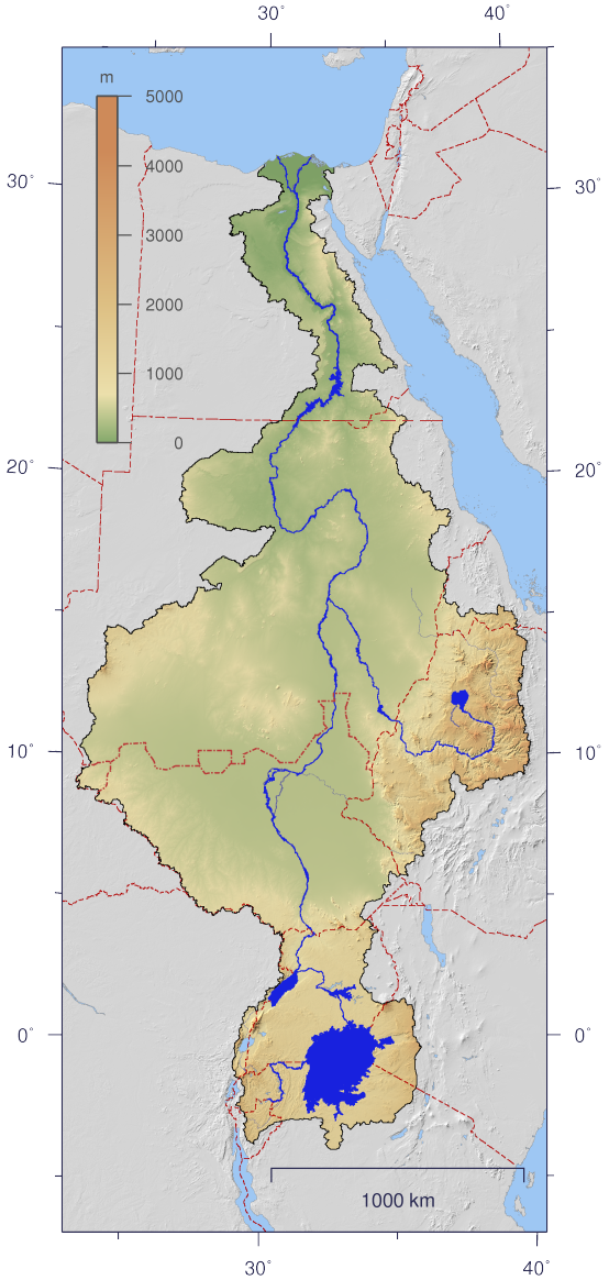
English: Course and Watershed of the Nile with topography shading and political boundaries.
Deutsch: Verlauf und Einzugsgebiet des Nils mit Reliefschattierung und Staatsgrenzen.
العربية: مجرى نهر النيل و الأراضي التي تروى بماءه مع طوبوغرافيا الأرض المحيطة به و الحدود السياسية |
| Date | |
| Soorce | The map has been created with the Generic Mapping Tools: http://gmt.soest.hawaii.edu/ using additional public domain data from the VMAP0 and HYDRO1K data sets. The map is in Transverse Mercator projection with central meridian at 32.5° east. |
| Author | Imagico |
| Permission (Reuisin this file) |
This file is licensed under the Creative Commons Attribution-Share Alike 2.5 Generic license.
|
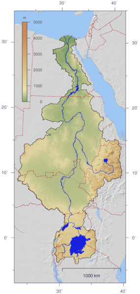
| Other versions | Image:Nile_watershed_plain.png |
Licensin
I, the copyright holder of this work, hereby publish it under the following license:
This file is licensed under the Creative Commons Attribution-Share Alike 2.5 Generic license.
- Ye are free:
- tae share – tae copy, distribute an transmit the wirk
- tae remix – tae adapt the wirk
- Unner the follaein condeetions:
- attribution – Ye must attribute the wirk in the manner specified bi the author or licensor (but nae in ony way that suggests that thay endorse ye or yer uise o the wirk).
- share alik – If ye alter, transform, or big upon this wirk, ye mey distribute the resultin wirk anly unner the same or seemilar license tae this ane.
File history
Clap oan ae date/time fer tae see the file aes it kithed at that time.
| Date/Time | Thummnail | Dimensions | Uiser | Comment | |
|---|---|---|---|---|---|
| current | 21:06, 25 August 2016 | | 554 × 1,164 (560 KB) | Janitoalevic | Updated borders. |
| 13:59, 4 Januar 2007 |  | 554 × 1,164 (527 KB) | Imagico | {{Information |Description= {{en|Course and Watershed of the Nile with topography shading and political boundaries.}} {{de|Verlauf und Einzugsgebiet des Nils mit Reliefschattierung und Staatsgrenzen.}} |Source=The map has been created with the [[:en:Gener |
Eimage airtins
The follaein pages airts tae this image:
Global file uisage
The follaein ither wikis uise this file:
- Uisage on af.wikipedia.org
- Uisage on ar.wikipedia.org
- Uisage on as.wikipedia.org
- Uisage on ca.wikipedia.org
- Uisage on cdo.wikipedia.org
- Uisage on ckb.wikipedia.org
- Uisage on crh.wikipedia.org
- Uisage on da.wikipedia.org
- Uisage on en.wikipedia.org
- Uisage on es.wikipedia.org
- Uisage on fa.wikipedia.org
- Uisage on fr.wikipedia.org
- Uisage on fy.wikipedia.org
- Uisage on hy.wikipedia.org
- Uisage on hyw.wikipedia.org
- Uisage on incubator.wikimedia.org
- Uisage on ja.wikipedia.org
- Uisage on ja.wikibooks.org
- Uisage on jbo.wikipedia.org
- Uisage on kbd.wikipedia.org
- Uisage on lez.wikipedia.org
- Uisage on lv.wikipedia.org
- Uisage on new.wikipedia.org
- Uisage on nl.wikipedia.org
- Uisage on nn.wikipedia.org
- Uisage on no.wikipedia.org
- Uisage on nso.wikipedia.org
- Uisage on pms.wikipedia.org
- Uisage on roa-rup.wikipedia.org
- Uisage on ru.wikipedia.org
- Uisage on si.wikipedia.org
- Uisage on sl.wikipedia.org
View mair global usage o this file.