File:Moskvarivermap.png
Nae heier resolution available.
Moskvarivermap.png (500 × 500 pixels, file size: 168 KB, MIME type: image/png)
Ootline
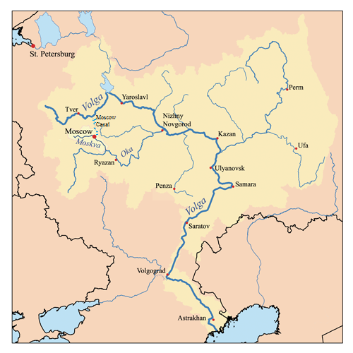
| Descreeption | This is a map of the Volga River system with the Moskva River highlighted. I, Karl Musser, created it based on USGS data. |
| Date | 14 September 2006 (original upload date) |
| Soorce | No machine-readable source provided. Own work assumed (based on copyright claims). |
| Author | No machine-readable author provided. Kmusser assumed (based on copyright claims). |
Licensin
I, the copyright holder of this work, hereby publish it under the following license:
This file is licensed under the Creative Commons Attribution-Share Alike 2.5 Generic license.
- Ye are free:
- tae share – tae copy, distribute an transmit the wirk
- tae remix – tae adapt the wirk
- Unner the follaein condeetions:
- attribution – Ye must attribute the wirk in the manner specified bi the author or licensor (but nae in ony way that suggests that thay endorse ye or yer uise o the wirk).
- share alik – If ye alter, transform, or big upon this wirk, ye mey distribute the resultin wirk anly unner the same or seemilar license tae this ane.
File history
Clap oan ae date/time fer tae see the file aes it kithed at that time.
| Date/Time | Thummnail | Dimensions | Uiser | Comment | |
|---|---|---|---|---|---|
| current | 14:21, 9 Julie 2015 | | 500 × 500 (168 KB) | Nyttend | Crude modifications to highlight the Moscow Canal |
| 17:08, 23 Julie 2007 |  | 500 × 500 (151 KB) | Kmusser | Ural river fix | |
| 14:48, 17 October 2006 |  | 500 × 500 (37 KB) | Kmusser | ||
| 19:04, 14 September 2006 |  | 500 × 500 (37 KB) | Kmusser | This is a map of the Volga River system with the Moskva River highlighted. I, Karl Musser, created it based on USGS data. {{self|cc-by-sa-2.5}} Category:Maps of rivers |
Eimage airtins
The follaein pages airts tae this image:
Global file uisage
The follaein ither wikis uise this file:
- Uisage on af.wikipedia.org
- Uisage on ar.wikipedia.org
- Uisage on br.wikipedia.org
- Uisage on cs.wikipedia.org
- Uisage on cy.wikipedia.org
- Uisage on de.wikipedia.org
- Uisage on en.wikipedia.org
- Uisage on eo.wikipedia.org
- Uisage on es.wikipedia.org
- Uisage on frr.wikipedia.org
- Uisage on fy.wikipedia.org
- Uisage on he.wikipedia.org
- Uisage on hi.wikipedia.org
- Uisage on hr.wikipedia.org
- Uisage on id.wikipedia.org
- Uisage on it.wikipedia.org
- Uisage on ja.wikipedia.org
- Uisage on ml.wikipedia.org
- Uisage on mn.wikipedia.org
- Uisage on ms.wikipedia.org
- Uisage on my.wikipedia.org
- Uisage on nl.wikipedia.org
- Uisage on nn.wikipedia.org
- Uisage on pl.wikipedia.org
- Uisage on pl.wiktionary.org
- Uisage on pt.wikipedia.org
- Uisage on ro.wikipedia.org
- Uisage on simple.wikipedia.org
- Uisage on sl.wikipedia.org
- Uisage on sw.wikipedia.org
- Uisage on ta.wikipedia.org
- Uisage on th.wikipedia.org
- Uisage on tr.wikipedia.org
- Uisage on ur.wikipedia.org
- Uisage on zh.wikipedia.org