File:Missouri River basin map.png

Size o this luikower: 800 × 575 pixels. Ither resolutions: 320 × 230 pixels | 640 × 460 pixels | 1,024 × 736 pixels | 1,280 × 920 pixels | 1,496 × 1,075 pixels.
Oreeginal file (1,496 × 1,075 pixels, file size: 2.63 MB, MIME type: image/png)
Ootline
| Descreeption |
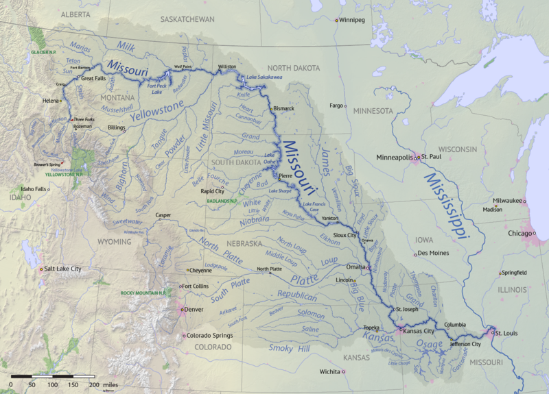
English: Map of the Missouri River drainage basin in the US and Canada. made using USGS and Natural Earth data. Replacement for File:Missouririvermap.jpg. |
| Date | |
| Soorce | Ain wirk |
| Author | Shannon1 |
.png)
Licensin
I, the copyright holder of this work, hereby publish it under the following licenses:

|
Permission is grantit tae copy, distribute an/or modify this document unner the terms o the GNU Free Documentation License, Version 1.2 or ony later version published bi the Free Software Foundation; wi no Invariant Sections, no Front-Cover Texts, an no Back-Cover Texts. A copy o the license is includit in the section enteetled GNU Free Documentation License. |
This file is licensed under the Creative Commons Attribution-Share Alike 4.0 International, 3.0 Unported, 2.5 Generic, 2.0 Generic and 1.0 Generic license.
- Ye are free:
- tae share – tae copy, distribute an transmit the wirk
- tae remix – tae adapt the wirk
- Unner the follaein condeetions:
- attribution – Ye must attribute the wirk in the manner specified bi the author or licensor (but nae in ony way that suggests that thay endorse ye or yer uise o the wirk).
- share alik – If ye alter, transform, or big upon this wirk, ye mey distribute the resultin wirk anly unner the same or seemilar license tae this ane.
Ye mey select the license o yer choice.
File history
Clap oan ae date/time fer tae see the file aes it kithed at that time.
| Date/Time | Thummnail | Dimensions | Uiser | Comment | |
|---|---|---|---|---|---|
| current | 00:15, 9 Apryle 2018 | | 1,496 × 1,075 (2.63 MB) | Shannon1 | missing label |
| 21:56, 30 Mairch 2018 |  | 1,500 × 1,080 (2.8 MB) | Shannon1 | slight fixes | |
| 19:30, 30 Mairch 2018 |  | 1,500 × 1,078 (2.78 MB) | Shannon1 | {{Information |description ={{en|1=Map of the Missouri River drainage basin in the US and Canada. made using USGS and Natural Earth data. Replacement for File:Missouririvermap.jpg.}} |source =Own work |author =Shannon1 |date =2018-03-21 }} Category:Missouri River |
Eimage airtins
The follaein pages airts tae this image:
Global file uisage
The follaein ither wikis uise this file:
- Uisage on af.wikipedia.org
- Uisage on azb.wikipedia.org
- Uisage on az.wiktionary.org
- Uisage on ba.wikipedia.org
- Uisage on be.wikipedia.org
- Uisage on bh.wikipedia.org
- Uisage on bn.wikipedia.org
- Uisage on ca.wikipedia.org
- Uisage on cv.wikipedia.org
- Uisage on da.wikipedia.org
- Uisage on en.wikipedia.org
- Missouri River
- Grand River (South Dakota)
- User:Shannon1/Sandbox 5
- User:Shannon1/Maps
- Yellowstone expedition
- List of longest rivers of the United States (by main stem)
- List of tributaries of the Missouri River
- Wikipedia:Graphics Lab/Map workshop/Archive/Jul 2011
- List of dams in the Missouri River watershed
- User:Shannon1/Maps/to-do
- Joseph LaBarge
- Spread Eagle (steamboat)
- Emilie (steamboat)
- Uisage on es.wikipedia.org
- Iowa
- Dakota del Norte
- Dakota del Sur
- Denver
- Río Misuri
- Bismarck (Dakota del Norte)
- Misuri
- Río Yellowstone
- Lincoln (Nebraska)
- Omaha (Nebraska)
- Columbia (Misuri)
- Kansas City (Misuri)
- Topeka
- Río Marías
- Kansas City (Kansas)
- Río Cheyenne
- Río Gallatin
- Great Falls (Montana)
- Río Platte
- Río Milk
- Río James (Dakotas)
- Río Smoky Hill
- Río Saline (Kansas)
- Río Niobrara
View mair global usage o this file.