File:Map showing the Départements of Algeria from 1962-1968 and 1968-1974.svg

Size of this PNG preview of this SVG file: 424 × 600 pixels. Ither resolutions: 170 × 240 pixels | 339 × 480 pixels | 543 × 768 pixels | 724 × 1,024 pixels | 1,448 × 2,048 pixels | 744 × 1,052 pixels.
Oreeginal file (SVG file, nominallie 744 × 1,052 pixels, file size: 77 KB)
Ootline
| Descreeption |
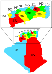
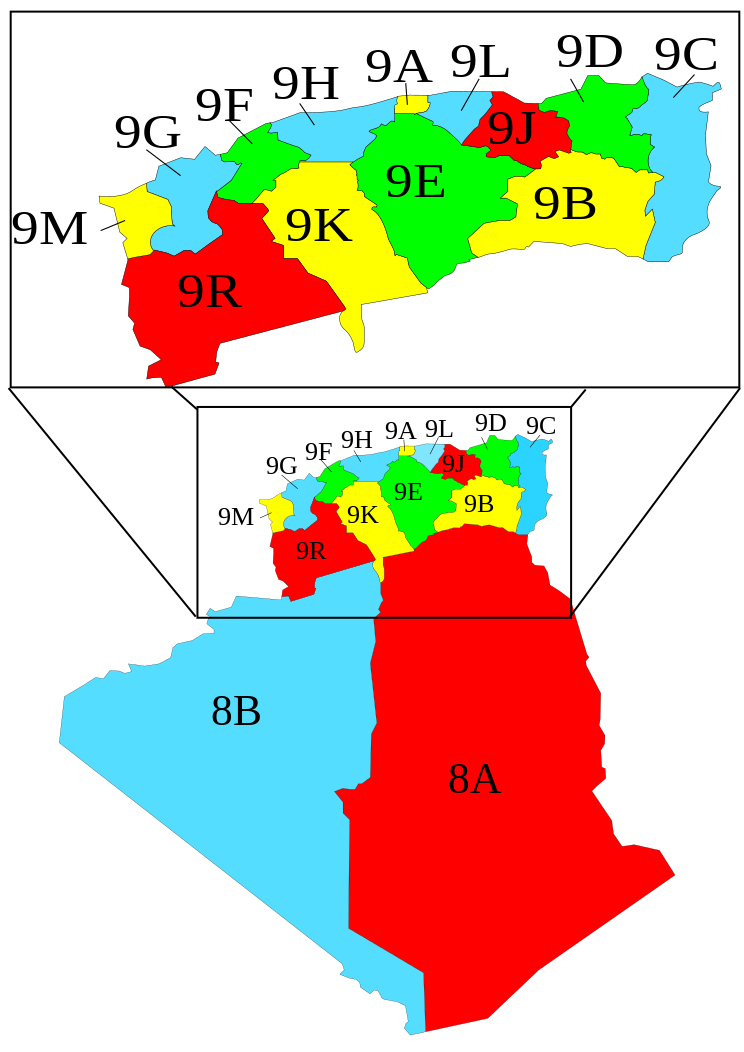
English: A map showing the Départements of Algeria from 1962-1968 and 1968-1974 when they where called "provinces".
Français : Carte des départements français d'Algérie (1957-1962), devenus les départements algériens (1962-1968), renommés wilayas en 1968. |
| Date | |
| Soorce | Image:Algeria_elections_91_by_province.svg by Chabacano |
| Author | Escondites |
Légende
- 8A : Département des Oasis
- 8B : Département de la Saoura
- 9A : Département d'Alger
- 9B : Département de Batna
- 9C : Département de Bône
- 9D : Département de Constantine
- 9E : Département de Médéa
- 9F : Département de Mostaganem
- 9G : Département d'Oran
- 9H : Département d'Orléansville
- 9J : Département de Sétif
- 9K : Département de Tiaret
- 9L : Département de Tizi-Ouzou
- 9M : Département de Tlemcen
- 9R : Département de Saïda
Licensin
Mustafaa at the English Wikipedia, the copyright holder of this work, hereby publishes it under the following license:

|
Permission is grantit tae copy, distribute an/or modify this document unner the terms o the GNU Free Documentation License, Version 1.2 or ony later version published bi the Free Software Foundation; wi no Invariant Sections, no Front-Cover Texts, an no Back-Cover Texts. A copy o the license is includit in the section enteetled GNU Free Documentation License. |
| This file is licensed unner the Creative Commons Attribution-Share Alike 3.0 Unported license. | ||
| Attribution: Mustafaa at the English Wikipedia | ||
| ||
| This licensing tag was added to this file as part of the GFDL licensing update. |
File history
Clap oan ae date/time fer tae see the file aes it kithed at that time.
| Date/Time | Thummnail | Dimensions | Uiser | Comment | |
|---|---|---|---|---|---|
| current | 11:02, 7 November 2007 | | 744 × 1,052 (77 KB) | Escondites | == Summary == {{Information |Description= A map showing the Départements, Algeria from 1962-1968 and 1968-1974 when they where called "provinces". |Source= Image:Algeria_elections_91_by_province.svg by {{u|Ch |
Eimage airtins
The follaein pages airts tae this image:
Global file uisage
The follaein ither wikis uise this file:
- Uisage on ar.wikipedia.org
- Uisage on ast.wikipedia.org
- Uisage on ca.wikipedia.org
- Uisage on de.wikipedia.org
- Uisage on el.wikipedia.org
- Uisage on en.wikipedia.org
- Uisage on es.wikipedia.org
- Uisage on et.wikipedia.org
- Uisage on fa.wikipedia.org
- Uisage on fi.wikipedia.org
- Uisage on fr.wikipedia.org
- Uisage on hu.wikipedia.org
- Uisage on it.wikipedia.org
- Uisage on ja.wikipedia.org
- Uisage on ps.wikipedia.org
- Uisage on pt.wikipedia.org
- Uisage on vi.wikipedia.org
- Uisage on zh.wikipedia.org