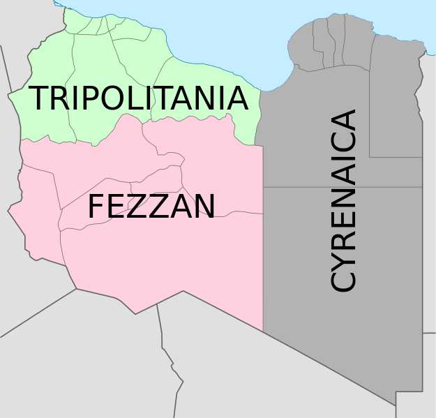
File:Map of traditional provinces of Libye-en.svg

Size of this PNG preview of this SVG file: 625 × 599 pixels. Ither resolutions: 250 × 240 pixels | 501 × 480 pixels | 801 × 768 pixels | 1,068 × 1,024 pixels | 2,136 × 2,048 pixels | 969 × 929 pixels.
Oreeginal file (SVG file, nominallie 969 × 929 pixels, file size: 106 KB)
File history
Clap oan ae date/time fer tae see the file aes it kithed at that time.
| Date/Time | Thummnail | Dimensions | Uiser | Comment | |
|---|---|---|---|---|---|
| current | 08:36, 24 August 2021 |  | 969 × 929 (106 KB) | أحمد الغرباوي | File uploaded using svgtranslate tool (https://svgtranslate.toolforge.org/). Added translation for ar. |
| 15:44, 6 December 2020 |  | 969 × 929 (104 KB) | ידידיה צ' צבאן | File uploaded using svgtranslate tool (https://svgtranslate.toolforge.org/). Added translation for he. | |
| 03:46, 12 October 2011 |  | 969 × 929 (104 KB) | Spesh531 | updated to current internal boundaries | |
| 12:50, 30 August 2011 |  | 969 × 929 (147 KB) | Orange Tuesday | see http://www.crwflags.com/fotw/flags/ly_1951.html for source on traditional colours | |
| 01:40, 30 August 2011 |  | 969 × 929 (124 KB) | Hellerick | Found no information on "traditional association" | |
| 20:24, 13 Juin 2011 |  | 969 × 929 (147 KB) | Kmusser | shift colors to match traditional association | |
| 11:04, 29 Apryle 2011 |  | 969 × 929 (125 KB) | Hellerick | Neutral colors; + foreign nations borders | |
| 13:02, 16 Mairch 2011 |  | 969 × 929 (121 KB) | Bourrichon | typo | |
| 13:01, 16 Mairch 2011 |  | 969 × 929 (121 KB) | Bourrichon | +bug typo | |
| 12:58, 16 Mairch 2011 |  | 969 × 929 (112 KB) | Bourrichon | {{Information |Description={{de|Historische provinzen (Governorates) Libyens}} {{en| Map of the three '''{{w|Governorates of Libya}}'''. After independence in 1951, until 1963, Libya was divided into three governorates (''{{w|muhafazat}}''): '''{{w|Cyrena |
Eimage airtins
The follaein pages airts tae this image:
Global file uisage
The follaein ither wikis uise this file:
- Uisage on ast.wikipedia.org
- Uisage on az.wikipedia.org
- Uisage on bs.wikipedia.org
- Uisage on ca.wikipedia.org
- Uisage on cs.wikipedia.org
- Uisage on diq.wikipedia.org
- Uisage on en.wikipedia.org
- History of Libya
- Libya
- Geography of Libya
- Demographics of Libya
- Politics of Libya
- Economy of Libya
- Mass media in Libya
- Transport in Libya
- Armed Forces of the Libyan Arab Jamahiriya
- Foreign relations of Libya under Muammar Gaddafi
- Fatimid Caliphate
- Idris of Libya
- List of cities in Libya
- Operation Sonnenblume
- Libyan dinar
- List of heads of state of Libya
- Districts of Libya
- Great Man-Made River
- List of colonial governors of Italian Cyrenaica
- List of heads of government of Libya
- Music of Libya
- Elections in Libya
- Karamanli dynasty
- Ahmed Karamanli
- Culture of Libya
- Central Bank of Libya
- Public Scout and Girl Guide Movement
- General People's Congress (Libya)
- Human rights in Libya
- Subdivisions of Libya
- Provinces of Libya
- Islamic Tripolitania and Cyrenaica
- Ottoman Tripolitania
- Italian colonization of Libya
- History of Libya under Muammar Gaddafi
- Chadian–Libyan War
- Ancient Libya
- Template:Libya topics
- Media of Libya
- Kingdom of Libya
- Minister of Foreign Affairs (Libya)
View mair global usage o this file.


