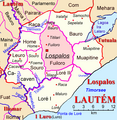
File:Lospalos posto administrativo.png

Size o this luikower: 558 × 600 pixels. Ither resolutions: 223 × 240 pixels | 447 × 480 pixels | 715 × 768 pixels | 1,128 × 1,212 pixels.
Oreeginal file (1,128 × 1,212 pixels, file size: 1 MB, MIME type: image/png)
File history
Clap oan ae date/time fer tae see the file aes it kithed at that time.
| Date/Time | Thummnail | Dimensions | Uiser | Comment | |
|---|---|---|---|---|---|
| current | 21:00, 23 Januar 2016 |  | 1,128 × 1,212 (1 MB) | J. Patrick Fischer | Außenbeschriftung wieder eingefügt |
| 20:26, 11 Januar 2016 |  | 1,128 × 1,212 (328 KB) | J. Patrick Fischer | adding Nualata correction Otcho-Tchau | |
| 20:47, 3 Januar 2010 |  | 1,128 × 1,212 (345 KB) | J. Patrick Fischer | Three more villages in Muapitine, rename Soro-Lua in Soru-Lua | |
| 00:21, 2 Januar 2010 |  | 1,128 × 1,212 (367 KB) | J. Patrick Fischer | three mistakes fixed | |
| 14:50, 29 December 2009 |  | 1,128 × 1,212 (341 KB) | J. Patrick Fischer | New version by using File:Administrative map of the Lautem district of East Timor.png of Maximilian Dörrbecker (Chumwa) and new geographical names and spelling according Ministerial Document 199/2009, | |
| 16:50, 5 Julie 2009 |  | 1,444 × 1,476 (1.23 MB) | J. Patrick Fischer | Loré II -> Loré I new river: Vahraru | |
| 20:39, 12 Juin 2009 |  | 1,444 × 1,476 (1.63 MB) | J. Patrick Fischer | Some new river names | |
| 13:46, 11 Juin 2009 |  | 1,444 × 1,476 (1.6 MB) | J. Patrick Fischer | Namaluto river | |
| 13:03, 11 Juin 2009 |  | 1,444 × 1,476 (1.56 MB) | J. Patrick Fischer | typo river Iraulau -> Irarau | |
| 12:15, 7 Juin 2009 |  | 1,444 × 1,476 (1.47 MB) | J. Patrick Fischer | {{Information |Description={{en|1=Map of subdistrict of Lospalos, district Lautém, Timor-Leste}} {{de|1=Karte des Subdistrikts Lospalos, Distrikt Lautém, Timor-Leste}} |Source=Eigenes Werk (own work) |Author=[[User:J. Patrick Fischer|J. Patrick Fischer] |
Eimage airtins
The follaein pages airts tae this image:
Global file uisage
The follaein ither wikis uise this file:
- Uisage on de.wikipedia.org
- Uisage on de.wikivoyage.org
- Uisage on en.wikipedia.org
- Uisage on fr.wikipedia.org
- Uisage on id.wikipedia.org
- Uisage on incubator.wikimedia.org
- Uisage on ja.wikipedia.org
- Uisage on ko.wikipedia.org
- Uisage on tet.wikipedia.org
- Uisage on war.wikipedia.org
- Uisage on www.wikidata.org
- Uisage on zh.wikipedia.org