File:Lebanon districts Aley.png

Size o this luikower: 486 × 599 pixels. Ither resolutions: 194 × 240 pixels | 600 × 740 pixels.
Oreeginal file (600 × 740 pixels, file size: 41 KB, MIME type: image/png)
Ootline
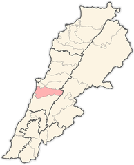
| Descreeption |
English: Map of districts in Lebanon, highlighting the Aley District |
| Date | |
| Soorce | Ain wirk |
| Author | Hanhil |
Based on Image:Lebanon districts Matn.png
Licensin
| I, the copyright holder of this work, release this work into the public domain. This applies worldwide. In some countries this may not be legally possible; if so: I grant anyone the right to use this work for any purpose, without any conditions, unless such conditions are required by law. |
File history
Clap oan ae date/time fer tae see the file aes it kithed at that time.
| Date/Time | Thummnail | Dimensions | Uiser | Comment | |
|---|---|---|---|---|---|
| current | 10:24, 31 Mey 2008 | | 600 × 740 (41 KB) | Hanhil | {{Information |Description={{en|1=Map of districts in Lebanon, highlighting the Aley District}} |Source=eigen werk (own work) |Author=Hanhil |Date=2008-05-31 |Permission= |other_versions= }} Based on Image:Lebanon districts Matn.png { |
Eimage airtins
The follaein pages airts tae this image:
Global file uisage
The follaein ither wikis uise this file:
- Uisage on ar.wikipedia.org
- قائمة مدن لبنان
- بيصور
- عين داره
- صوفر
- سوق الغرب
- قالب:قضاء عاليه
- عاليه (لبنان)
- عين عنوب
- عبيه
- أغميد
- عرمون
- بدادون
- بشامون
- بسوس
- شملان
- كحالة
- كيفون
- نبع الصفا
- قماطية
- سلفاية
- بتاتر
- بحمدون الضيعة
- بحمدون المحطة
- بحوارة
- بخشتيه
- بدغان
- بساتين (عاليه)
- بسرين
- بطلون
- بعلشميه
- بعورته
- بليبل
- بمكين
- بمهريه
- بنيه
- بوزريده
- تعزانية
- حبرمون
- حومال
- دفون
- دقون
- دويرالرمان
- دير قوبل
- رجمة
- رشميا
- رمحالا
- رملية
- رويسة النعمان
- سرحمول
- سلفايا
View mair global usage o this file.