File:Lakebalkhashbasinmap.png

Size o this luikower: 800 × 546 pixels. Ither resolutions: 320 × 218 pixels | 640 × 437 pixels | 1,024 × 698 pixels | 1,466 × 1,000 pixels.
Oreeginal file (1,466 × 1,000 pixels, file size: 1.52 MB, MIME type: image/png)
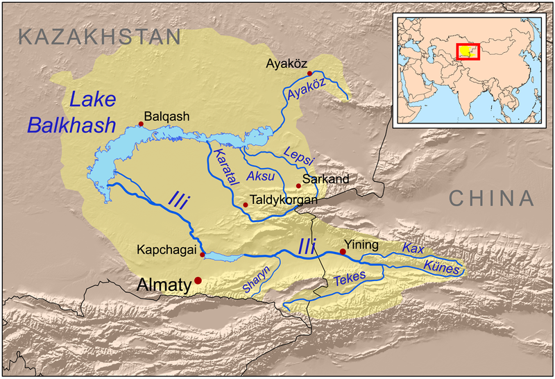
| Descreeption | This is a map of the Lake Balkhash drainage basin, including the Ili River and its tributaries. |
| Date | |
| Soorce | Own work using Digital Chart of the World and GTOPO data, labels based on GEOnet. UNEP and Decrease of river runoff in the Lake Balkhash basin in Central Asia by Kader Kezer and Hiroshi Matsuyama used as references. |
| Author | Kmusser |
| Other versions | Magyar svg |
I, the copyright holder of this work, hereby publish it under the following license:
This file is licensed unner the Creative Commons Attribution-Share Alike 3.0 Unported license.
- Ye are free:
- tae share – tae copy, distribute an transmit the wirk
- tae remix – tae adapt the wirk
- Unner the follaein condeetions:
- attribution – Ye must attribute the wirk in the manner specified bi the author or licensor (but nae in ony way that suggests that thay endorse ye or yer uise o the wirk).
- share alik – If ye alter, transform, or big upon this wirk, ye mey distribute the resultin wirk anly unner the same or seemilar license tae this ane.
File history
Clap oan ae date/time fer tae see the file aes it kithed at that time.
| Date/Time | Thummnail | Dimensions | Uiser | Comment | |
|---|---|---|---|---|---|
| current | 21:01, 22 December 2008 | | 1,466 × 1,000 (1.52 MB) | Kmusser | {{Information |Description=This is a map of the Lake Balkhash drainage basin, including the Ili River and its tributaries. |Source=Own work using http://www.maproom.psu.edu/dcw/ Digital Chart of the World and [ |
Eimage airtins
The'r nae pages airts tae this eimage.
Global file uisage
The follaein ither wikis uise this file:
- Uisage on af.wikipedia.org
- Uisage on ar.wikipedia.org
- Uisage on arz.wikipedia.org
- Uisage on ast.wikipedia.org
- Uisage on azb.wikipedia.org
- Uisage on az.wikipedia.org
- Uisage on ba.wikipedia.org
- Uisage on bg.wikipedia.org
- Uisage on bn.wikipedia.org
- Uisage on bs.wikipedia.org
- Uisage on ca.wikipedia.org
- Uisage on cs.wikipedia.org
- Uisage on da.wikipedia.org
- Uisage on de.wikipedia.org
- Uisage on el.wikipedia.org
- Uisage on en.wikipedia.org
View mair global usage o this file.