File:LY-Sabratha.png
Nae heier resolution available.
LY-Sabratha.png (700 × 600 pixels, file size: 28 KB, MIME type: image/png)
Ootline
| Descreeption |
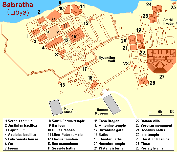
English: Map (rough) of ancient Sabratha, Libya, own work composed from various map references |
| Date | |
| Soorce | Ain wirk |
| Author | Hobe / Holger Behr |
| Other versions |
|

| Object location | | View this and other nearby images on: OpenStreetMap |
|---|
Licensin
| I, the copyright holder of this work, release this work into the public domain. This applies worldwide. In some countries this may not be legally possible; if so: I grant anyone the right to use this work for any purpose, without any conditions, unless such conditions are required by law. |
File history
Clap oan ae date/time fer tae see the file aes it kithed at that time.
| Date/Time | Thummnail | Dimensions | Uiser | Comment | |
|---|---|---|---|---|---|
| current | 17:59, 8 September 2010 | | 700 × 600 (28 KB) | Hobe | {{Information |Description={{en|1=Map (rough) of ancient Sabratha, Libya, own work composed from various mapreferences}} |Source={{own}} |Author=Hobe / Holger Behr |Date=2010-04-25 |Permission= |other_versions= }} |
Eimage airtins
The follaein pages airts tae this image:
Global file uisage
The follaein ither wikis uise this file:
- Uisage on ar.wikipedia.org
- Uisage on ca.wikipedia.org
- Uisage on de.wikipedia.org
- Uisage on en.wikipedia.org
- Uisage on en.wikivoyage.org
- Uisage on fr.wikipedia.org
- Uisage on gl.wikipedia.org
- Uisage on hr.wikipedia.org
- Uisage on hy.wikipedia.org
- Uisage on mk.wikipedia.org
- Uisage on mt.wikipedia.org
- Uisage on pt.wikipedia.org
- Uisage on sh.wikipedia.org
- Uisage on sv.wikipedia.org
- Uisage on vi.wikipedia.org
- Uisage on www.wikidata.org