File:Kirovograd province location map.svg

Size of this PNG preview of this SVG file: 533 × 291 pixels. Ither resolutions: 320 × 175 pixels | 640 × 349 pixels | 1,024 × 559 pixels | 1,280 × 699 pixels | 2,560 × 1,398 pixels.
Oreeginal file (SVG file, nominallie 533 × 291 pixels, file size: 149 KB)
Ootline
| Descreeption |
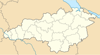
English: Location map of Kirovograd province, Ukraine
Русский: Позиционная карта Кировоградской области, Украина
Українська: Карта Кіровоградської області, Україна |
| Date | |
| Soorce | Ain wirk |
| Author | Urutseg |
Licensin
| I, the copyright holder of this work, release this work into the public domain. This applies worldwide. In some countries this may not be legally possible; if so: I grant anyone the right to use this work for any purpose, without any conditions, unless such conditions are required by law. |
File history
Clap oan ae date/time fer tae see the file aes it kithed at that time.
| Date/Time | Thummnail | Dimensions | Uiser | Comment | |
|---|---|---|---|---|---|
| current | 09:48, 29 Juin 2014 | | 533 × 291 (149 KB) | קרלוס הגדול | lighter borders between provinces |
| 21:35, 3 December 2010 |  | 533 × 291 (149 KB) | Urutseg | == Summary == {{Information |Description={{en|1=Location map of Kirovograd province, Ukraine}} {{ru|1=Позиционная карта Кировоградской области, Украина}} |Source={{own}} |Author=Urutseg |Date=20 |
Eimage airtins
The follaein pages airts tae this image:
Global file uisage
The follaein ither wikis uise this file:
- Uisage on ar.wikipedia.org
- Uisage on bg.wikipedia.org
- Uisage on de.wikipedia.org
- Uisage on es.wikipedia.org
- Uisage on fa.wikipedia.org
- Uisage on he.wikipedia.org
- Uisage on hy.wikipedia.org
- Կրոպիվնիցկի
- Կաղապար:Տեղորոշման քարտեզ Ուկրաինա Կիրովոգրադի մարզ
- Ալեքսանդրիա (քաղաք, Ուկրաինա)
- Ալեքսանդրո-Պաշչենկովո
- Ալեքսանդրովկա (գյուղ, Ալեքսանդրիայի շրջան)
- Անդրեևկա (գյուղ, Ալեքսանդրիայի շրջան)
- Բանդուրովկա (գյուղ, Ալեքսանդրիայի շրջան)
- Բերյոզովկա (գյուղ, Ալեքսանդրիայի շրջան)
- Բուտովսկոե
- Բրատսկոե (գյուղ, Ալեքսանդրիայի շրջան)
- Գայոկ (գյուղ, Ալեքսանդրիայի շրջան)
- Գայովոե (ավան, Ալեքսանդրիայի շրջան)
- Գլուբոկոե (գյուղ, Ալեքսանդրիայի շրջան)
- Գոլովկովկա (գյուղ, Ալեքսանդրիայի շրջան)
- Գուլևիչի (գյուղ, Ալեքսանդրիայի շրջան)
- Գրիգորովկա (գյուղ, Ալեքսանդրիայի շրջան)
- Դևիչիե Պոլե (գյուղ, Ալեքսանդրիայի շրջան)
- Դիբրովի
- Դոբրոնադիևկա
- Դոլինսկոե (գյուղ, Ալեքսանդրիայի շրջան)
- Զանֆիրովկա
- Զապորոժիե (գյուղ, Ալեքսանդրիայի շրջան)
- Զելյոնայա Բալկա (գյուղ, Ալեքսանդրիայի շրջան)
- Զրազկովոե (գյուղ, Ալեքսանդրիայի շրջան)
- Իզմայլովկա (գյուղ, Ալեքսանդրիայի շրջան)
View mair global usage o this file.