File:KeizersgrachtReguliersgrachtAmsterdam.jpg

Size o this luikower: 800 × 533 pixels. Ither resolutions: 320 × 213 pixels | 640 × 427 pixels | 1,024 × 683 pixels | 1,280 × 853 pixels | 2,560 × 1,707 pixels | 3,456 × 2,304 pixels.
Oreeginal file (3,456 × 2,304 pixels, file size: 4.91 MB, MIME type: image/jpeg)
Ootline
| Descreeption |
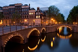
Nederlands: Zicht op de Reguliersgracht op de hoek met de Keizersgracht in Amsterdam, Nederland bij het ondergaan van de zon.
English: A view of the Reguliersgracht on the corner with the Keizersgracht, in Amsterdam, the Netherlands at dusk.
Afrikaans: Amsterdamse gragte tydens skemer, die Reguliersgrag by die aansluiting met die Keizersgrag
Čeština: Křižovatka dvou kanálů (Reguliersgracht a Keizersgracht) v nizozemském Amsterdamu za soumraku.
Dansk: Udsigt over Reguliersgracht i Amsterdam, Holland, hvor den krydser Keizersgracht.
Deutsch: Kreuzung zweier Grachten (Reguliersgracht und Keizersgracht) in der niederländischen Hauptstadt Amsterdam in der Abenddämmerung.
Esperanto: Interkruciĝo de kanaloj Reguliersgracht kaj Keizersgracht je noktiĝo en Amsterdamo.
Español: Vista al atardecer del Keizersgracht, Ámsterdam, Países Bajos.
Français : Une vue de la Reguliersgracht au croisement de la Keizersgracht, au crépuscule à Amsterdam (Pays-Bas).
Magyar: Amszterdami részlet a Keizersgracht és a Reguliersgracht csatornák összefolyásánál
Македонски: Поглед на Регулирсграхт на аголот со Кајзерсграхт во Амстердам, Холандија, во мугри.
Polski: Widok skrzyżowania Amsterdamskich kanałów Reguliersgracht i Keizersgracht o zmierzchu.
Português: Vista ao entardecer do canal Regulier no cruzamento com o Keizer, Amsterdã, Países Baixos.
Română: Reguliersgracht, colţ cu Keizersgracht, în Amsterdam, Olanda la amurg.
Русский: «Перекрёсток» двух каналов, Reguliersgracht и Keizersgracht, в сумерках (Амстердам, Нидерланды)
Українська: На перехресті двох амстердамських каналів, Реґулірсґрахт (Reguliersgracht) та Кайзерсґрахт (Keizersgracht) у сутінкову пору.
中文(简体):荷兰阿姆斯特丹平凡运河和国王运河交汇处夜景
中文(繁體):荷蘭阿姆斯特丹修士運河和國王運河交匯處夜景
|
||||||||||||
| Date | |||||||||||||
| Soorce | Ain wirk | ||||||||||||
| Author | Massimo Catarinella | ||||||||||||
| Permission (Reuisin this file) |
See license, attribution required - contact me to discuss less restrictive commercial licensing terms by email Special:EmailUser/Massimo Catarinella or leave a message on my talk page | ||||||||||||
| Other versions |


.jpg)
| Camera location | | View this and other nearby images on: OpenStreetMap |
|---|
This image was selected as picture of the day on Wikimedia Commons for 8 December 2008. It was captioned as follows: English: A view of the Reguliersgracht on the corner with the Keizersgracht, in Amsterdam, The Netherlands at dusk. Other languages:
Afrikaans: Amsterdamse gragte tydens skemer, die Reguliersgrag by die aansluiting met die Keizersgrag. Čeština: Křižovatka dvou kanálů (Reguliersgracht a Keizersgracht) v nizozemském Amsterdamu za soumraku. Deutsch: Kreuzung zweier Grachten (Reguliersgracht und Keizersgracht) in der niederländischen Hauptstadt Amsterdam in der Abenddämmerung. English: A view of the Reguliersgracht on the corner with the Keizersgracht, in Amsterdam, The Netherlands at dusk. Esperanto: Interkruciĝo de kanaloj Reguliersgracht kaj Keizersgracht je noktiĝo en Amsterdamo. Français : Intersection entre deux canaux (Reguliersgracht et Keizersgracht) à la tombée de la nuit à Amsterdam. Nederlands: Zicht op de Reguliersgracht op de hoek met de Keizersgracht in Amsterdam, Nederland bij het ondergaan van de zon. Polski: Widok skrzyżowania amsterdamskich kanałów Reguliersgracht i Keizersgracht o zmierzchu. Português: Vista ao entardecer do canal Regulier no cruzamento com o Keizer, Amsterdã, Países Baixos. Русский: «Перекрёсток» двух каналов, Reguliersgracht и Keizersgracht, в сумерках (Амстердам, Нидерланды) Українська: На перехресті двох амстердамських каналів, Реґулірсґрахт (Reguliersgracht) та Кайзерсґрахт (Keizersgracht) у сутінкову пору. 中文: 荷兰阿姆斯特丹修士运河和国王运河交汇处夜景 |
|
Licensin
I, the copyright holder of this work, hereby publish it under the following license:
This file is licensed unner the Creative Commons Attribution-Share Alike 3.0 Unported license.
- Ye are free:
- tae share – tae copy, distribute an transmit the wirk
- tae remix – tae adapt the wirk
- Unner the follaein condeetions:
- attribution – Ye must attribute the wirk in the manner specified bi the author or licensor (but nae in ony way that suggests that thay endorse ye or yer uise o the wirk).
- share alik – If ye alter, transform, or big upon this wirk, ye mey distribute the resultin wirk anly unner the same or seemilar license tae this ane.
| Annotations | This image is annotated: View the annotations at Commons |
File history
Clap oan ae date/time fer tae see the file aes it kithed at that time.
| Date/Time | Thummnail | Dimensions | Uiser | Comment | |
|---|---|---|---|---|---|
| current | 23:13, 24 August 2009 | | 3,456 × 2,304 (4.91 MB) | Massimo Catarinella | sRGB |
| 18:31, 13 August 2008 |  | 3,456 × 2,304 (1.11 MB) | Massimo Catarinella | {{Information |Description={{en|1=A view of the Keizersgracht on the corner with the Reguliersgracht in Amsterdam, The Netherlands at dawn.}} |Source=Own work by uploader |Author=Massimo Catarinella |Date=11 August 2008 |Permi |
Eimage airtins
The follaein pages airts tae this image:
Global file uisage
The follaein ither wikis uise this file:
- Uisage on an.wikipedia.org
- Uisage on ar.wikipedia.org
- Uisage on ary.wikipedia.org
- Uisage on arz.wikipedia.org
- Uisage on awa.wikipedia.org
- Uisage on az.wikipedia.org
- Uisage on ba.wikipedia.org
- Uisage on bg.wikipedia.org
- Uisage on bh.wikipedia.org
- Uisage on bn.wikipedia.org
- Uisage on co.wikipedia.org
- Uisage on crh.wikipedia.org
- Uisage on cs.wikipedia.org
- Uisage on cu.wikipedia.org
- Uisage on cv.wikipedia.org
- Uisage on de.wikipedia.org
- Uisage on el.wikivoyage.org
- Uisage on en.wikipedia.org
- Amsterdam
- User talk:Ilse@
- Category talk:Geography
- Portal:Netherlands
- Portal:Architecture
- Portal:Geography/Featured picture archive
- Wikipedia:WikiProject Urban studies and planning
- Portal:European Union/Selected picture
- Wikipedia:Featured pictures/Places/Urban
- Portal:Architecture/Townscape images
- Portal:European Union/Selected picture/23
- User talk:Ilse@/archive
- Wikipedia:WikiProject Netherlands
- Wikipedia talk:WikiProject Cities/Archive 8
- User:Massimo Catarinella
- User talk:Massimo Catarinella
- Wikipedia:Featured pictures thumbs/13
- Wikipedia:Featured picture candidates/Keizersgracht in Amsterdam
- Wikipedia:Wikipedia Signpost/2008-09-08/Features and admins
- Wikipedia:Featured picture candidates/September-2008
- Wikipedia:Wikipedia Signpost/2008-09-08/SPV
- Wikipedia:Picture peer review/Architecture in Amsterdam
- User:Mzajac/Infobox settlement
- Wikipedia:Picture peer review/Archives/Jan-Mar 2009
- Wikipedia:Picture of the day/April 2009
View mair global usage o this file.