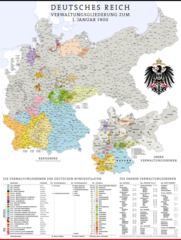
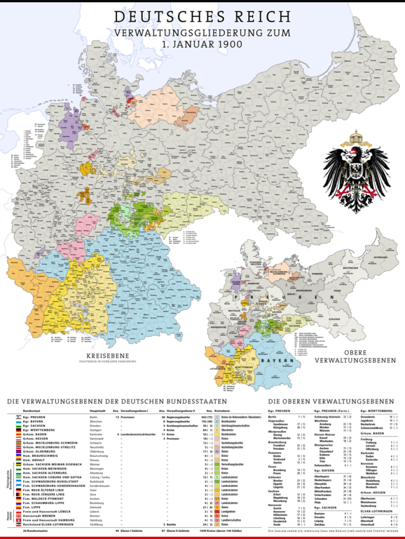
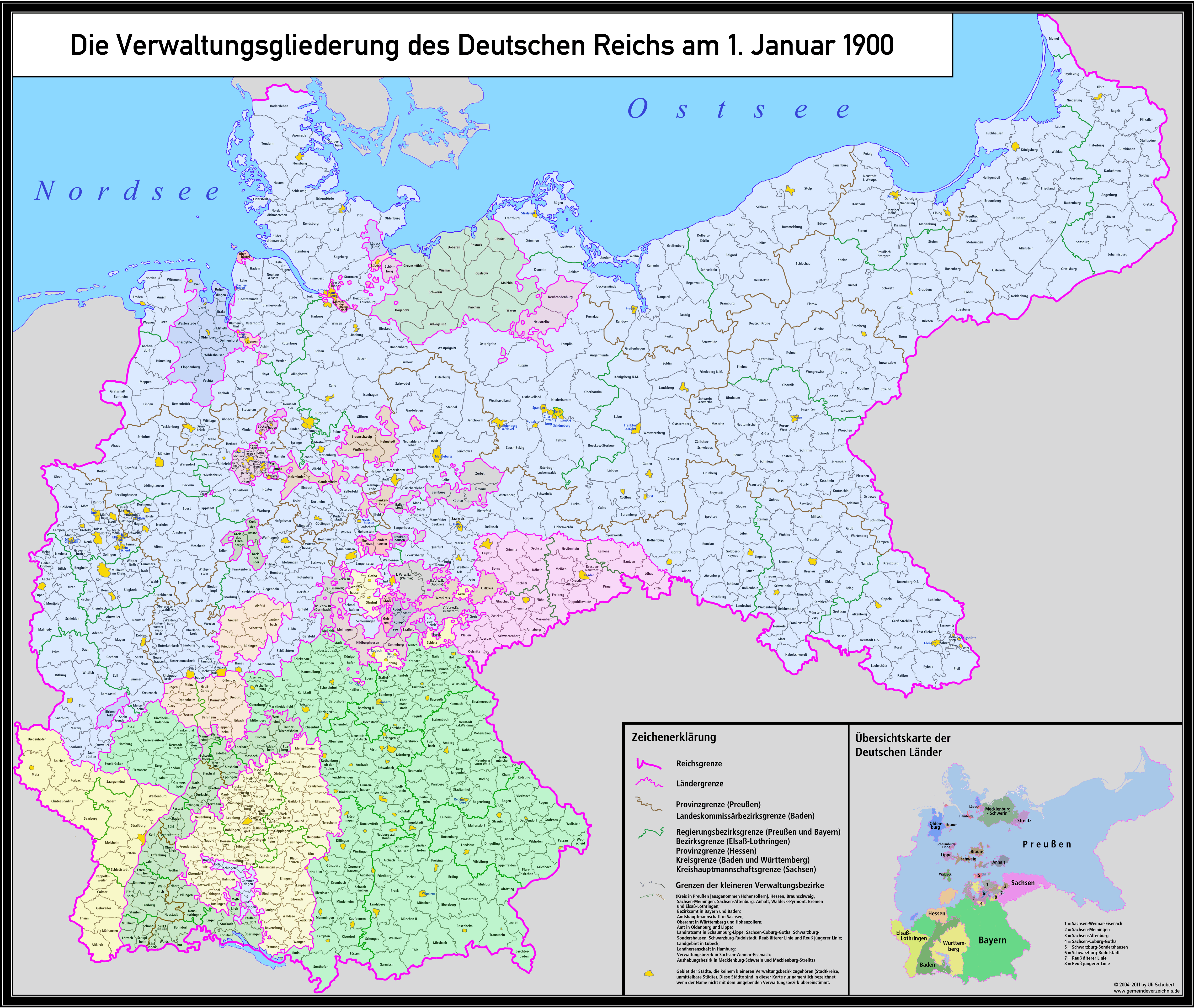
File:Karte Deutsches Reich, Verwaltungsgliederung 1900-01-01.png

Size o this luikower: 452 × 600 pixels. Ither resolutions: 181 × 240 pixels | 361 × 480 pixels | 578 × 768 pixels | 771 × 1,024 pixels | 1,543 × 2,048 pixels | 5,013 × 6,654 pixels.
Oreeginal file (5,013 × 6,654 pixels, file size: 6 MB, MIME type: image/png)
Ootline
| Descreeption |
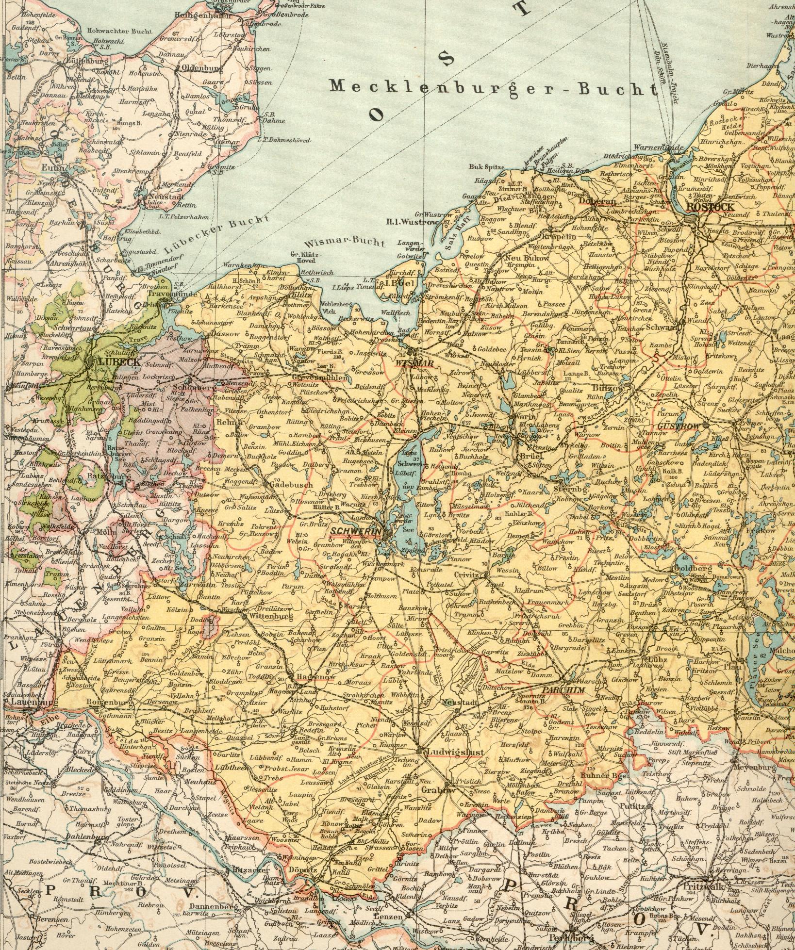
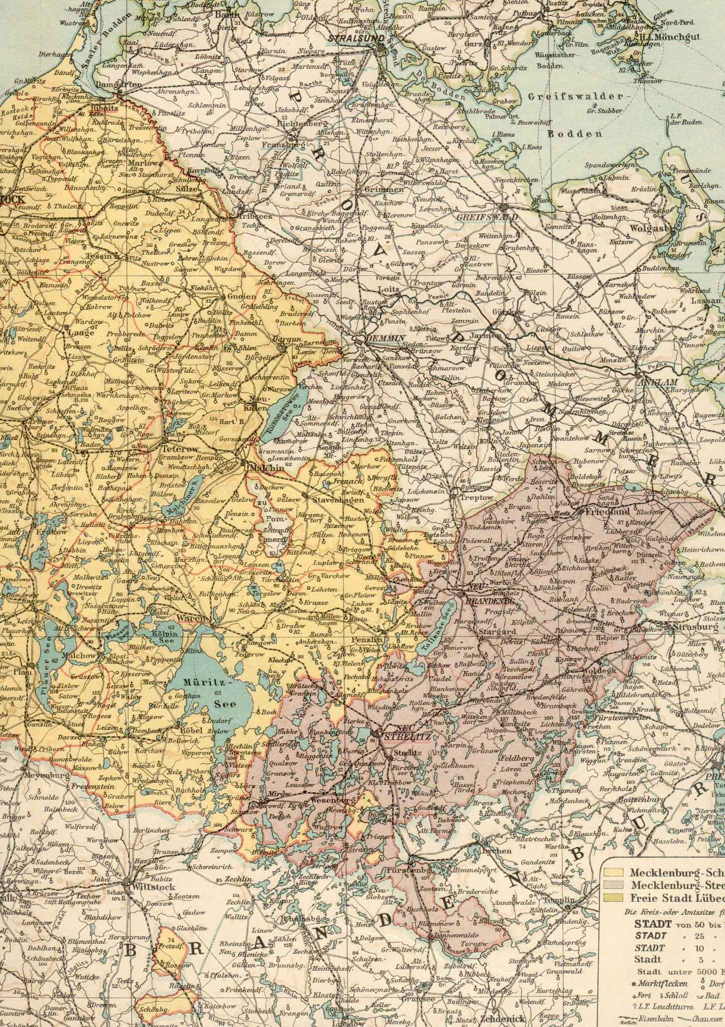
Deutsch: Karte der Verwaltungsgliederung des Deutschen Reichs zum Stand 1. Januar 1900
English: Administrative Map of the German Empire as of January 1st, 1900 |
| Date | |
| Soorce |
Ain wirk, using following data and information:
...and many more maps and information from diverse Wikipedia articles.
For the other coats of arms diverse elements of the following coat-of-arms-files:
|
| Author | Maximilian Dörrbecker (Chumwa) |
| Permission (Reuisin this file) |
This file is licensed under the Creative Commons Attribution-Share Alike 2.0 Generic license.
Sie dürfen das Bild zu den folgenden Bedingungen nutzen:
|
| Other versions |
|


.svg)
.jpg)
.svg)
.svg)
.svg)
.svg)
.svg)
.svg)
File history
Clap oan ae date/time fer tae see the file aes it kithed at that time.
| Date/Time | Thummnail | Dimensions | Uiser | Comment | |
|---|---|---|---|---|---|
| current | 15:02, 8 Mairch 2024 | | 5,013 × 6,654 (6 MB) | Pilum2211 | Previous Pload error (?) |
| 15:01, 8 Mairch 2024 |  | 5,013 × 6,654 (3.33 MB) | Pilum2211 | Reverted to version as of 08:21, 20 April 2020 (UTC) | |
| 13:52, 8 Mairch 2024 |  | 5,013 × 6,654 (6 MB) | Pilum2211 | Added "Kreis Memel" to the "Regierungsbezirk Königsberg" | |
| 08:21, 20 Apryle 2020 |  | 5,013 × 6,654 (3.33 MB) | NordNordWest | wider -> wieder | |
| 17:42, 9 August 2019 |  | 5,013 × 6,654 (5.18 MB) | Chumwa | corr | |
| 20:49, 5 Februar 2019 |  | 5,013 × 6,654 (5.2 MB) | Chumwa | Heiligenbein → Heiligenbeil | |
| 07:47, 15 August 2017 |  | 5,013 × 6,654 (5.38 MB) | Chumwa | Aurich war am 1.1.1900 ein eigener Regierungsbezirk in der preußischen Provinz Hannover | |
| 21:05, 10 Mey 2017 |  | 5,013 × 6,654 (5.19 MB) | Chumwa | Die Enklave im mecklenburg-schwerinschen Kreis Malchin gehört nicht zu Mecklenburg-Strelitz, sondern zur preussischen Provinz Pommern, Kreis Demmin. | |
| 10:49, 5 December 2016 |  | 5,013 × 6,654 (5.49 MB) | Androl | Neckars-ulm -> Neckar-sulm | |
| 20:42, 20 November 2016 |  | 5,013 × 6,654 (5.19 MB) | Chumwa | Beeskow-Strokow -> Beeskow-Storkow |
Eimage airtins
The follaein pages airts tae this image:
Global file uisage
The follaein ither wikis uise this file:
- Uisage on af.wikipedia.org
- Uisage on als.wikipedia.org
- Uisage on an.wikipedia.org
- Uisage on ar.wikipedia.org
- Uisage on ast.wikipedia.org
- Uisage on azb.wikipedia.org
- Uisage on az.wikipedia.org
- Uisage on ba.wikipedia.org
- Uisage on be-tarask.wikipedia.org
- Uisage on be.wikipedia.org
- Uisage on bg.wikipedia.org
- Uisage on bn.wikipedia.org
- Uisage on br.wikipedia.org
- Uisage on ca.wikipedia.org
- Uisage on ckb.wikipedia.org
- Uisage on cs.wikipedia.org
- Uisage on da.wikipedia.org
- Uisage on de.wikipedia.org
- Königreich Preußen
- Homburg
- Deutsches Kaiserreich
- Deutsche Reichsgründung
- Liste der Wappen in Deutschland
- Benutzer:Chumwa
- Liste der Landkreise Preußens
- Staatsleistungen
- Kreisordnung (Preußen)
- Geschichte der Kreisbildung in Deutschland
- Kreisreformen in Preußen
- Verwaltungsgliederung Preußens
- Benutzer Diskussion:Chumwa/Archiv/2015/3. Quartal
- Benutzer:Chumwa/SomeOfMyFiles
- Benutzer:Natus37/Preußen
- Uisage on el.wikipedia.org
- Uisage on en.wikipedia.org
- Uisage on eo.wikipedia.org
- Uisage on es.wikipedia.org
- Uisage on et.wikipedia.org
- Uisage on eu.wikipedia.org
- Uisage on fi.wikipedia.org
View mair global usage o this file.