File:Jarvenpaa neighbourhoods.jpg

Oreeginal file (645 × 735 pixels, file size: 133 KB, MIME type: image/jpeg)
Ootline
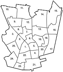
| Descreeption |
English: A map of neighbourhoods in the city of Järvenpää. The names of the individual neighbourhoods are listed below. The official statistical district numbers are in parenthesis after the name. |
| Date | |
| Soorce | Ain wirk |
| Author | Heikki Narko |
Licensin
- Ye are free:
- tae share – tae copy, distribute an transmit the wirk
- tae remix – tae adapt the wirk
- Unner the follaein condeetions:
- attribution – Ye must attribute the wirk in the manner specified bi the author or licensor (but nae in ony way that suggests that thay endorse ye or yer uise o the wirk).
- share alik – If ye alter, transform, or big upon this wirk, ye mey distribute the resultin wirk anly unner the same or seemilar license tae this ane.
File history
Clap oan ae date/time fer tae see the file aes it kithed at that time.
| Date/Time | Thummnail | Dimensions | Uiser | Comment | |
|---|---|---|---|---|---|
| current | 01:43, 4 Juin 2020 | | 645 × 735 (133 KB) | Saarik | updated the district numbers on the map |
| 19:47, 21 Mairch 2007 |  | 645 × 735 (113 KB) | Heycci | {{Information |Description=English: A map of neighbourhoods in the city of Järvenpää. |Source=Own work |Date=21.3.2007 |Author=Heikki Narko |Permission= |other_versions= }} |
Eimage airtins
The follaein pages airts tae this image:
Global file uisage
The follaein ither wikis uise this file:
- Uisage on cs.wikipedia.org
- Uisage on en.wikipedia.org
- Uisage on es.wikipedia.org
- Uisage on fi.wikipedia.org
- Uisage on fr.wikipedia.org
- Uisage on gl.wikipedia.org
- Uisage on sk.wikipedia.org
- Uisage on smn.wikipedia.org
- Uisage on vep.wikipedia.org
- Uisage on www.wikidata.org