File:IndonesiaBali.png
Nae heier resolution available.
IndonesiaBali.png (800 × 375 pixels, file size: 79 KB, MIME type: image/png)
Ootline
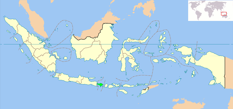
Locator map of Indonesian province of Bali showing provincial boundaries. Based on Image:Indonesia_provinces_blank_map.svg. Created for use in en:Wikiproject Indonesia Cartography.
NB: Please note, this map will probably need further editing in order to make the position of Bali clearer. For now, we are simply standardising all Indonesia Provincial locator maps, and will make additional changes once all standard maps have been uploaded
Licensin
| This file is licensed unner the Creative Commons Attribution-Share Alike 3.0 Unported license. Subject to disclaimers. | ||
| ||
| This licensing tag was added to this file as part of the GFDL licensing update. |

|
Permission is grantit tae copy, distribute an/or modify this document unner the terms o the GNU Free Documentation License, Version 1.2 or ony later version published bi the Free Software Foundation; wi no Invariant Sections, no Front-Cover Texts, an no Back-Cover Texts. A copy o the license is includit in the section enteetled GNU Free Documentation License. Subject to disclaimers. |
File history
Clap oan ae date/time fer tae see the file aes it kithed at that time.
| Date/Time | Thummnail | Dimensions | Uiser | Comment | |
|---|---|---|---|---|---|
| current | 10:28, 14 September 2008 | | 800 × 375 (79 KB) | AnonyLog | Added world locator from last version. |
| 13:08, 6 Mairch 2007 |  | 800 × 375 (97 KB) | Bwmodular | New version of Locator Map, higher resolution map, standard across all Indonesian Province maps, showing West Irian Jaya province. | |
| 23:32, 2 October 2005 |  | 300 × 220 (14 KB) | Romanm | uploaded current version from English Wikipedia | |
| 00:59, 2 October 2005 |  | 300 × 220 (14 KB) | Fangz~commonswiki | Reduced file size. Jeez, I'm making alot of mistakes, eh? | |
| 00:55, 2 October 2005 |  | 300 × 220 (28 KB) | Fangz~commonswiki | Reverted to earlier revision | |
| 00:54, 2 October 2005 | 300 × 122 (7 KB) | Fangz~commonswiki | Reverted to earlier revision | ||
| 00:53, 2 October 2005 |  | 300 × 220 (28 KB) | Fangz~commonswiki | Edited to give global context. (Using BlankMap-World.png) Done using the Gimp | |
| 05:36, 14 August 2005 | 300 × 122 (7 KB) | *drew~commonswiki | Map of Indonesia showing the location of Bali. Taken from English Wikipedia. {{GFDL}} Category:Bali |
Eimage airtins
The'r nae pages airts tae this eimage.
Global file uisage
The follaein ither wikis uise this file:
- Uisage on ar.wikipedia.org
- Uisage on arz.wikipedia.org
- Uisage on ast.wikipedia.org
- Uisage on bcl.wikipedia.org
- Uisage on be-tarask.wikipedia.org
- Uisage on bjn.wikipedia.org
- Uisage on bn.wikipedia.org
- Uisage on bs.wikipedia.org
- Uisage on ca.wikipedia.org
- Uisage on ceb.wikipedia.org
- Uisage on de.wikipedia.org
- Uisage on de.wikinews.org
- Uisage on el.wikipedia.org
- Uisage on en.wikipedia.org
- Uisage on eo.wikipedia.org
- Uisage on es.wikinews.org
- Uisage on eu.wikipedia.org
- Uisage on fa.wikipedia.org
- Uisage on fi.wikipedia.org
- Uisage on fo.wikipedia.org
- Uisage on fr.wikipedia.org
- Uisage on fy.wikipedia.org
- Uisage on gl.wikipedia.org
- Uisage on gu.wikipedia.org
- Uisage on hak.wikipedia.org
- Uisage on he.wikipedia.org
- Uisage on hy.wikipedia.org
- Uisage on ja.wikipedia.org
- Uisage on ja.wikinews.org
- Uisage on ka.wikipedia.org
- Uisage on km.wiktionary.org
- Uisage on kn.wikipedia.org
- Uisage on la.wiktionary.org
- Uisage on lt.wikipedia.org
- Uisage on lv.wikipedia.org
- Uisage on mai.wikipedia.org
- Uisage on mk.wikipedia.org
- Uisage on ml.wikipedia.org
- Uisage on ms.wikipedia.org
- Uisage on ne.wikipedia.org
View mair global usage o this file.